Start website main content

Accessible trails

1 pathway

Sentieri per tutti...in questa categoria rientrano i sentieri progettati o riadattati perchè il contatto con l'ambiente naturale sia sempre di stimolo al miglioramento della vita personale di chiunque, con attenzione alle condizioni di disabilità motoria, sensoriale o della sfera psichica e relazionale...

Rio Ermolinos.jpg

Results

Gadoni, Foresta Corongia. Between breccas and disterrus

Access 

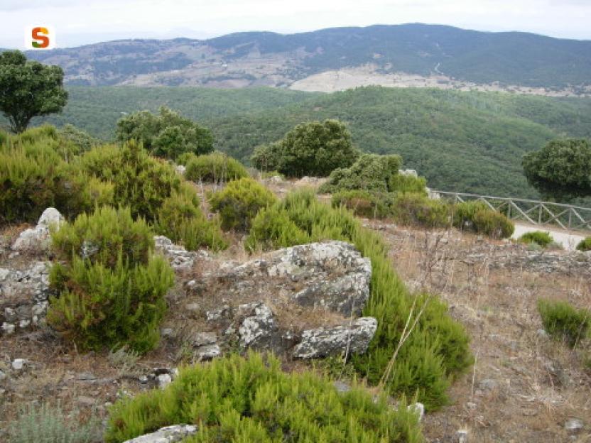
Depart from the centre of Gadoni along the SP2 in the direction of Seulo, then turning right onto the tarmac road in the direction of Funtana Raminosa. This beautiful road partly follows the miners' old route and runs alongside the allotments and orchards that they tended everyday, on their way to the mine, as they left the village. You gradually gain altitude, with increasingly broader views of the Flumendosa valleys, then you approach the buildings of the abandoned mine that occupies the Riu Saraxinus valley. The mining complex can be visited (www.visitgadoni.info) and a visit is highly recommended. Continue uphill for a few more kilometres until it ends, turning left and following the signs for Foresta Corongia on a partially unsurfaced road. When the road flattens out, you reach the Bauzzoni picnic area, where you leave the car. 

Su Campalini 

Continue on a dirt road on foot, ignoring some minor detours and turning left at the only obvious fork. Just below the road, reachable with some difficulty and unmarked, are the caves of Grutas de Perdu, with a scenic waterfall descending from the vault. The road you follow is now level, beneath a beautiful woodland area where you can identify the circular clearings, devoid of vegetation, where the charcoal burners built their threshing floors for the production of charcoal. Halfway along the long straight stretch, you come to a wooden signpost indicating Su Campalini: you leave the main dirt road and enter the woods, reaching the vertiginous edge of the Lartinatzu walls: here Foresta Corongia precipitates towards the Flumendosa riverbed and here stands a slender and bold rocky pinnacle, almost a bell tower, as its name in Sardinian seems to suggest.
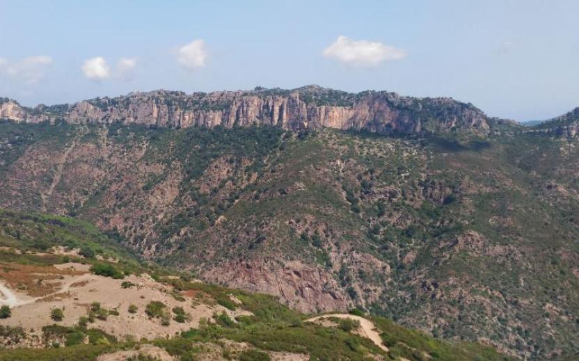
Is Breccas 

After a long panaoramic rest andbreak, you return to the dirt road continuing in a southerly direction until you come to a large fork in the road: Here you turn right, uphill, past a gate and continue on the main road. Soon the road becomes flat again, on clay soil and begins to skirt some unique isolated rock towers that become more and more numerous, until they form a veritable labyrinth of walls, caves, crevices and diaclasas. The area is known as Is Breccas and was the kingdom of shepherds and the bandit Torracorti, who lived over a century ago. 

Su Pinneddu 

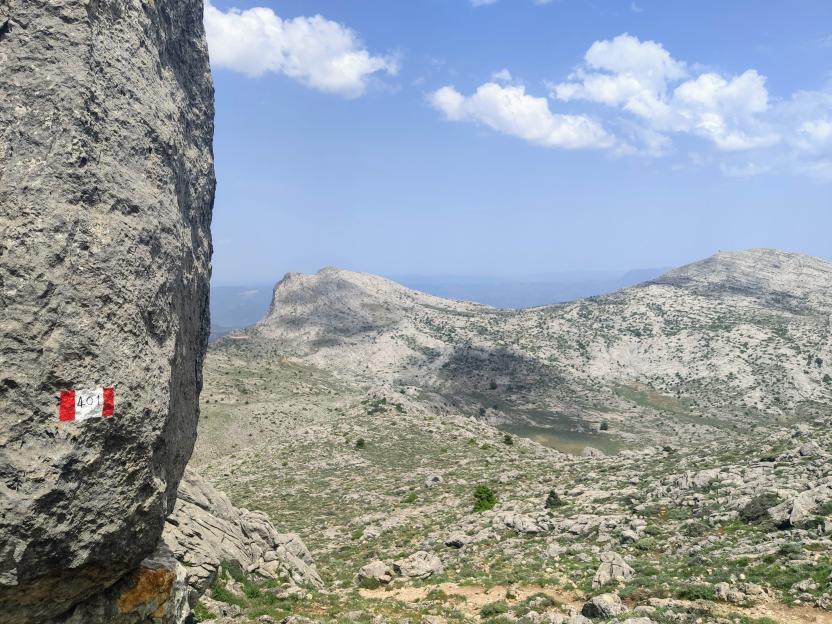
Exploring the labyrinth of Is Breccas is worth every minute spent and various floristic endemisms can be recognised in the walls, as you walk along the slender paths that follow the audacious conformations of the rock. You then continue along a dirt road until it emerges from the forest: here, on the right, stands an isolated tower known as Su Pinneddu. The road joins a main dirt track which you follow to the right, beginning to descend and reaching, after a long stretch in the forest, the first fork encountered on the way. Here you turn left, shortly reaching the Bauzzoni area and the car.

Itinerary roadbook

Lenght 25.600 m

Gadoni.gpx

Total elevation gain 1 022 metri

Gadoni, Foresta Corongia. Tra breccas e disterrus

Accesso 

Si parte dal centro abitato di Gadoni percorrendo la SP2 in direzione Seulo, prendendo poi a destra per strada asfaltata in direzione di Funtana Raminosa. La bella strada ricalca in parte la viabilità dei minatori e costeggia gli orti ed i frutteti che essi curavano recandosi alla miniera ogni giorno, partendo dal paese. Si guadagna gradualmente quota, con vista sempre più ampia sulle vallate del Flumendosa, addentrandosi poi tra gli edifici della miniera abbandonata che occupa la valle del Riu Saraxinus

Il complesso minerario è oggi visitabile (www.visitgadoni.info) e la sua visita è fortemente consigliata. Si procede ancora in salita per alcuni km finché essa termina, prendendo a sinistra e seguendo le indicazioni per Foresta Corongia su strada parzialmente sterrata. Quando la strada si spiana si raggiunge l’area attrezzata di Bauzzoni, dove si lascia l’auto. 

Su Campalini 

Si prosegue su strada sterrata a piedi, ignorando alcune deviazioni secondarie e prendendo a sinistra all’unico bivio evidente. Poco sotto la strada, raggiungibili con qualche difficoltà e non segnalate, si incontrerebbero le grotte di Grutas de Perdu, con una scenografica cascata che discende dalla volta. La strada che si percorre è ora in piano, sotto un bel bosco dove si riconoscono gli spiazzi circolari e privi di vegetazione dove i carbonai costruivano le loro aie per la produzione del carbone da legna. 

A metà del lungo rettilineo si incontra un cartello in legno che segnala Su Campalini: si abbandona la sterrata principale e ci si inoltra nel bosco, raggiungendo il ciglio vertiginoso delle pareti di Lartinatzu: qui Foresta Corongia precipita verso il greto del Flumendosa e qui si staglia un pinnacolo roccioso esile ed ardito, quasi un campanile, come il nome in sardo pare suggerire. 

Is Breccas 

Dopo una lunga sosta panoramica si ritorna sulla strada sterrata continuando in direzione sud finché si incontra un grosso bivio: qui si prende a destra, in salita, oltrepassando un cancello e proseguendo sulla strada principale. Ben presto la strada ritorna in piano, su terreno argilloso e comincia a costeggiare dei singolari torrioni isolati di roccia che divengono sempre più numerosi, fino a formare un vero e proprio labirinto di pareti, grotte, fenditure e diaclasi. La zona è nota come Is Breccas ed era il regno di pastori e del bandito Torracorti, vissuto oltre un secolo fa. 

Su Pinneddu 

L’esplorazione del labirinto di Is Breccas vale ogni minuto speso e nelle pareti si potranno riconoscere vari endemismi floristici, mentre si percorrono gli esili sentieri che seguono le ardite conformazioni della roccia. Si prosegue quindi ancora su sterrata finché essa esce dal bosco: qui, sulla destra, si staglia un torrione isolato noto come Su Pinneddu. La strada si congiunge ad una sterrata principale che si segue verso destra, cominciando a scendere ed raggiungendo dopo un lungo tratto nel bosco il primo bivio incontrato all’andata. Qui si prende a sinistra, raggiungendo in breve la zona di Bauzzoni e l’auto.

Itinerary roadbook

Lenght 25.600 m

Gadoni.gpx

Total elevation gain 1 022 metri

Sentiero Italia (Stage Z18) Separadorgiu - Terra Ona

Overview of the itinerary

Sentiero Italia runs the length of the island’s eastern side, covering its most important mountains, in 28 stages.  Starting from the north: it flanks the Monte Limbara massif, crosses the limestones of Mont’Albo and Tuttavista, skirting the Gulf of Orosei, it crosses the Supramonte, Gennargentu and the Tacchi of Ogliastra and reaches Perdasdefogu.  Further south, it passes through Armungia and the Gerrei sub-region. Lastly, it touches on the villages of Burcei and San Gregorio, continuing on the Sette Fratelli massif to the old prisons of Castiadas.

General information on Sentiero Italia (Grand Italian Trail)

Sentiero Italia, or Grand Italian Trail, as also explained on the official website, is a walking route that crosses the whole of Italy, using mainly but not exclusively “registered trails”.   
In particular, in Sardinia, not all the stages of the Sentiero Italia of CAI (Italian Alpine Club) are made of trails already included in the registry of the Sardinia Trail Network (RES), either because they have not yet been tested and approved or simply because they cannot be registered as they do not meet the requirements.  However, as a whole, the Sentiero Italia is the single longest walking route currently crossing Sardinia from the north (S. Teresa Gallura, stage Z 1) to the south (Castiadas, end of stage Z 28), touching on the most fascinating mountain areas in central-eastern Sardinia: the plateau of Buddusò, Tepilora, the Cedrino river valley, the ancient forests of Montes, Perda Liana and the regional forest of Montarbu, Monte Genis, and lastly the regional forest of Settefratelli (among the many crossed by the various stages of this long hiking itinerary).

Information on this stage of the trail

This is a medium-length stage that initially traces back a short stretch of stage Z17 and then continues in a southerly direction after leaving the dirt track. 

Walk along a trail recently traced by the Forestas Regional Agency, which will take you to the Bruncu Spina car park (Sardinia’s one and only ski area). Continue in a south-easterly direction and, after passing alongside Punta Paulinu following the contour line at about 1680 metres asl, you will arrive at a meeting point between two paths near Arcu Gennargentu (1650 asl). Continue along the ridge, crossing Punta La Marmora and, once you get to N39.98703° E9.32408°, take the path to your right in a south-westerly direction that takes you downhill to Arcu Sa Turzi (1604 m asl) and then continue in a southerly direction after a short bend to the east. Following the course of a stream, at elevations varying between 1440 and 1300 m asl, you will reach the Cuile Strumpu at about 1100 m asl, after paying a visit to the Nuragic village of Sa Idda ’e Ruinas

Continue on the dirt track until you reach the Cuile Prediargiu, which you will leave on your left to take a path, for about 3 km, currently marked with stone cairns, that leads to another dirt track heading north to the stop point of Terra Ona

This is a very scenic but fairly challenging stage without easy access to water. Warning: the trail may be exposed to fog.

Itinerary roadbook

Lenght 22.700 m

SI Z18.gpx

Total elevation gain 1 047 metri

Sentiero Italia (Tappa Z18) Separadorgiu - Terra Ona

In sintesi

Il Sentiero Italia attraversa in lunghezza il settore orientale dell’isola toccandone i sistemi montuosi più rilevanti, in 28 tappe.  Partendo da nord: tocca il massiccio del Monte Limbara, attraversa i calcari del Mont'Albo e del Tuttavista sfiorando il Golfo di Orosei,  attraversa il Supramonte, il Gennargentu, i Tacchi dell’Ogliastra e giunge a Perdasdefogu.  Più a sud, transita da Armungia e dalla subregione del Gerrei. Infine tocca l’abitato di Burcei e San Gregorio, per continuare nel massiccio dei Sette Fratelli fino alle vecchie carceri di Castiadas.

Informazioni generali sull'itinerario sentiero Italia

Il Sentiero Italia, come spiegato anche nel sito ufficiale, è un itinerario (o Cammino) lungo tutta l'Italia, che utilizza prevalentemente ma non esclusivamente "sentieri accatastati".   
In particolare, in Sardegna, non tutte le tappe del Sentiero Italia del CAI coincidono con sentieri già inseriti nel catasto della Rete Escursionistica della Sardegna (RES), perché non hanno ancora superato le verifiche di percorribilità oppure semplicemente perché non possono essere accatastati non avendone i requisiti.  Tuttavia, nel suo insieme, il Sentiero Italia rappresenta l'unica, la più grande dorsale escursionistica che attraversa attualmente la nostra Isola da nord (S. Teresa Gallura, tappa Z 1) a sud (Castiadas, fine tappa Z 28) toccando le aree montane della Sardegna centro-Orientale più affascinanti: l'altopiano di Buddusò, Tepilora, la valle del Cedrino, i boschi vetusti di Montes, Perda Liana e la foresta demaniale di Montarbu, il Monte Genis, e infine la foresta demaniale di Settefratelli (tra le tante attraversate dal lungo itinerario escursionistico a tappe).

Info sul percorso di questa tappa

Tappa di media lunghezza che ripercorre inizialmente un breve tratto della tappa Z17 per poi proseguire, in direzione sud, dopo aver lasciato la sterrata. 

Si cammina in un sentiero recentemente realizzato dall’Agenzia Regionale Fo.Re.S.T.A.S. che ci porta al parcheggio di Bruncu Spina (il sogno della Sardegna di poter avere impianti sciistici). Si prosegue in direzione sud-est e dopo aver costeggiato Punta Paulinu seguendo la curva di livello a circa 1680 slm, arriviamo ad una confluenza di sentieri in prossimità di Arcu Gennargentu (1650 slm). Continuiamo in cresta, attraversiamo Punta La Marmora ed arrivati a N39.98703° E9.32408° si prende il sentiero alla nostra destra in direzione sud-ovest che ci porta in discesa verso Arcu Sa Turzi (1604 slm) per poi proseguire in direzione sud dopo un breve tornante verso est. Costeggiando un corso di un rio, a quote variabili fra 1440 me 1300 raggiungiamo su sterrata il cuile Strumpu a circa 1100 slm, dopo aver visitato precedentemente il villaggio nuragico Sa Idda ‘e Ruinas

Continuiamo sulla sterrata per giungere nei pressi del cuile Prediargiu che lasceremo alla nostra sinistra per prendere un sentiero, per circa 3 km, attualmente segnalato con omini di pietra che ci porta ad una successiva sterrata in direzione nord del posto tappa di Terra Ona

Tappa molto panoramica ma abbastanza impegnativa con difficoltà di approvvigionamento idrico. Attenzione in caso di nebbia.


Informazioni utili

Lungo il percorso non sarà sempre presente la copertura telefonica

Itinerary roadbook

Lenght 22.700 m

SI Z18.gpx

Total elevation gain 1 047 metri