Accessible trails
Sentieri per tutti...in questa categoria rientrano i sentieri progettati o riadattati perchè il contatto con l'ambiente naturale sia sempre di stimolo al miglioramento della vita personale di chiunque, con attenzione alle condizioni di disabilità motoria, sensoriale o della sfera psichica e relazionale...

Image credits Sardegna Digital Library Regione Sardegna
Results
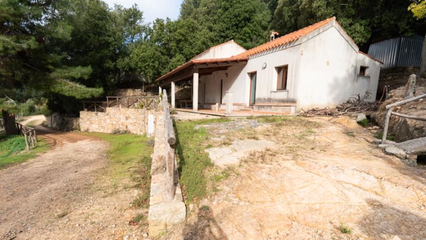
Cantina Ferraris - Starting point Trail D-112
The beautiful and old building has been renovated by the Forestas Agency and is now constantly manned; Sardinian deer are often visible in the surrounding area.
Trails 112 (to Ovile Linas) and 109 (to Murumannu) branch off from here.
Starting from the headquarters of the forest complex (Canale Serci), you reach the nursery (campu S'Isca) along the cart track - in fair condition. From here, you proceed on the dirt road towards the northwest, with the road surface gradually deteriorating. After passing a structure that serves as a collection point for the aqueduct, the road becomes a trail and keeps the now nearby course of the Rio Cannisonis to the left.
Trail 111, which leads to the high route (near Genna Sammuccu or Sambucu), starts from the Cantina Ferraris, reaching the dirt road just below the buildings of the old sheepfold, in a scenic position under the peaks of the area generically called Magusu.
Cantina Ferraris - Punto di partenza D-112
La bella e vecchia costruzione è stata ristrutturata dall’Agenzia Forestas ed oggi è costantemente presidiata; nei dintorni sono spesso visibili i cervi sardi.
Si diramano da qui i sentieri 112 (per Ovile Linas) e 109 (per Murumannu).
Partendo dalla sede del complesso forestale (Canale Serci) si raggiunge il vivaio (campu S'Isca) lungo la pista carrabile - in discrete condizioni. Da qui si procede nella sterrata in direzione nordovest, col fondo viario che va gradualmente a peggiorare. Superata una struttura che funge da raccolta dell’acquedotto, la strada diviene un sentiero e tiene a sinistra l’ormai vicino corso del Rio Cannisonis.
Il sentiero 111 che conduce all'alta via (presso Genna Sammuccu o Sambucu) parte dalla Cantina Ferraris, raggiungendo la sterrata poco sotto le costruzioni del vecchio ovile, in posizione scenografica sotto le cime della zona detta genericamente Magusu.
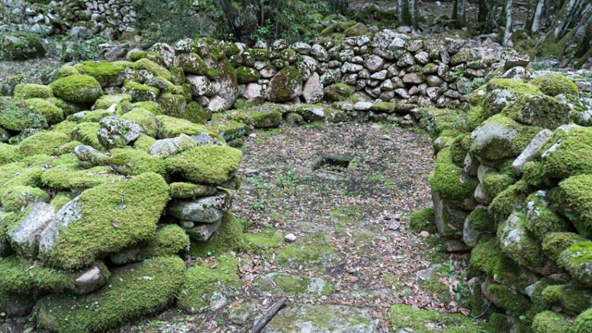
Linas Sheepfold - End of point D-112 and D-115
The Linas Sheepfold is currently a structure owned by the Forestas Agency: previously it was indeed a sheepfold, recently renovated.
It should not be confused with the Baita Porcella, also known as Baita Linas, located a short distance away along the D 112 trail, whose particular architecture is reminiscent of Alpine constructions. The structure is now in a state of disrepair, but in front of its entrance there is a natural clearing with an exceptional view of the entire path traveled and the highest peaks of the Linas.
How to get here
Linas Sheepfold can be reached both from trail D 112 and trail D 115.
Ovile Linas - punto di arrivo D-112 e D-115
L'Ovile Linas attualmente è una struttura di proprietà dell'Agenzia Forestas: in precedenza era appunto un ovile, recentemente ristrutturato.
Da non confondere con la Baita Porcella, nota anche come Baita Linas, poco distante lungo il sentiero D 112, la cui particolare architettura rimanda appunto a costruzioni alpine. La struttura è ora in stato di degrado, ma davanti al suo ingresso si trova una spianata naturale con una vista eccezionale sull’intero cammino percorso e sulle cime più alte del Linas.
How to get here
Si può raggiungere l'Ovile Linas sia dal sentiero D 112 che dal D 115.
Muru Mannu Waterfall - Arrival Point D-109
Muru Mannu is a waterfall located between the Sardinian municipalities of Villacidro and Gonnosfanadiga, both situated in the province of South Sardinia. Even today, the latter town claims its belonging to its territory. Composed of a single drop, for a total of approximately 70 meters or more, it is the highest waterfall on the entire island.
It originates from the Muru Mannu stream, which later takes the name Cannisoni stream. Like all Sardinian waterfalls, it is fed by torrential watercourses, therefore it can only be admired in the autumn-spring period, being dry from late spring onwards. It can be reached by a medium-difficulty trekking route of about 2 hours, well-marked and clean, which takes place entirely in the valley bottom.
This waterfall, like the entire Monte Linas massif, is surrounded by peaks that exceed an average of 800 meters in height, and is immersed in woods along with many other small waterfalls. Near Muru Mannu, there is the Cascatella del Rio Linas, composed of three small drops.
How to get here
Trail 109 is one of the most sought-after trails in Linas, leading to the highest waterfall in Sardinia, Muru Mannu. You'll traverse long mule tracks through the woods, passing ancient pig herders' shelters and reaching the Riu Cannisoni riverbed with various fords (impassable during periods of heavy rainfall) and a splendid view of the waterfall area. Further on, a trail for experienced hikers begins, allowing, with some acrobatics, to reach the foot of the waterfall (these passages require good physical condition and experience in movements on rough terrain).
Please Note: this last section, at the moment, is not part of trail 109, which ends before reaching the waterfall, which is a few hundred meters away but, during periods of high water, poses the difficulty of passages on slippery rock that require skill and great attention because they can be extremely risky.
Attention!
- Part of the itinerary becomes impassable in case of heavy rains, floods or significant water regimes. During particularly intense weather events, the conformation of the area makes these paths particularly risky from a hydrogeological point of view, especially due to the numerous fords that need to be crossed and which, in the rainy season, involve crossing raging streams. To avoid all these fords that force you to continuously move from the right to the left bank of the Cannisoni river and its tributaries, making the path difficult to travel after rains, a variant (109-A) is being studied that crosses the river only once, at the small bridge near the dirt road at the beginning of the route, and avoids any further ford by constantly staying on the right bank of the river, without needing to cross it again until arrival. This route uses old historical mule tracks, which require restoration and signage. The works are in progress in 2024 and therefore this alternative route is not yet available.
- ROUTE WITH SOME EXPOSED PASSAGES, with a sufficiently wide walking surface for easy passage, but in short sections on granite slabs or boulders which, in case of rain or on particularly humid days, can be very slippery, increasing the risk of falls on rock.
- There are some unauthorized cables and ropes present, which you should absolutely not rely on!
Cascata Muru Mannu - punto di arrivo D-109
Muru Mannu è una cascata situata tra i comuni sardi di Villacidro e Gonnosfanadiga, entrambi situati nella provincia del Sud Sardegna. Ancora oggi, quest'ultimo paese ne rivendica l'appartenenza al proprio territorio. Composta da un unico salto, per un totale di 70 metri e più all'incirca, è la cascata più alta di tutta l'isola.
Nasce dal rio Muru Mannu che poi prende il nome di rio Cannisoni. Come tutte le cascate sarde, è alimentata da corsi d'acqua a regime torrentizio, pertanto la si può ammirare solo nel periodo autunno-primaverile, essendo in secca dalla tarda primavera in poi. Può essere raggiunta con un percorso di trekking di media difficoltà e di circa 2 ore ben segnato e pulito che si svolge tutto in fondovalle.
Anche questa cascata come tutto il massiccio del Monte Linas è costeggiata da vette che superano di media gli 800 metri d'altezza, ed è immersa nei boschi assieme a tante altre piccole cascate. Nei pressi di Muru Mannu è presente la Cascatella del Rio Linas, composta da tre piccoli salti.
How to get here
Il sentiero 109 è uno dei sentieri più ambiti del Linas, per avvicinarsi alla cascata più alta della Sardegna, quella di Muru Mannu. Si percorreranno lunghe mulattiere nel bosco, passando accanto ad antichi ricoveri di porcari e raggiungendo il greto del Riu Cannisoni con vari guadi (impraticabili nei periodi di forti precipitazioni) e uno splendido panorama sulla zona della cascata. Più avanti parte un sentiero per escursionisti esperti che permette, con qualche acrobazia, di giungere ai piedi della cascata (questi passaggi presuppongono buono stato fisico ed esperienza nei movimenti su aree impervie).
Nota Bene: quest'ultimo tratto, al momento, non è parte del sentiero 109, che termina prima di raggiungere la cascata, che dista a poche centinaia di metri ma, nei periodi di piena, pone a chi volesse raggiungerla la difficoltà di passaggi su roccia scivolosa che richiedono perizia e grande attenzione perché possono risultare estremamente rischiosi.
Attenzione!
- Parte dell’itinerario diviene impercorribile in caso di forti piogge, piene o regimi idrici importanti. In occasione di eventi meteo particolarmente intensi, la conformazione dell'area rende questi sentieri particolarmente rischiosi dal punto di vista idrogeologico, soprattutto a causa dei numerosi guadi che è necessario attraversare e che, nella stagione delle piogge, comportano l'attraversamento di torrenti impetusi. Per evitare tutti questi guadi che costringono a passare continuamente dalla destra alla sinistra idrografica del rio Cannisoni e dei suoi affluenti, rendendo di difficile percorribilità il sentiero dopo le piogge, è allo studio una variante (109-A) che attraversa una sola volta il rio, nel ponticello vicino alla pista carrabile all'inizio del tracciato, ed evita ogni ulteriore guado mantenendosi costantemente alla destra idrografica del rio, senza necessità di attraversarlo più sino all'arrivo. Questo tracciato usa vecchie mulattiere storiche, che necessitano un ripristino e la segnaletica. I lavori sono in corso nel 2024 e quindi questo percorso alternativo non è ancora disponibile.
- PERCORSO CON ALCUNI PASSAGGI ESPOSTI, con piano di calpestio sufficientemente largo per il passaggio agevole, ma in brevi tratti su placche granitiche o massi che, in caso di pioggia o in giornate particolarmente umide, possono risultare assai scivolose, aumentando il rischio di cadute su roccia.
- Sono presenti alcuni cavi e corde non autorizzati, su cui non fare assolutamente affidamento!