Start website main content

Accessible trails

1 pathway

Sentieri per tutti...in questa categoria rientrano i sentieri progettati o riadattati perchè il contatto con l'ambiente naturale sia sempre di stimolo al miglioramento della vita personale di chiunque, con attenzione alle condizioni di disabilità motoria, sensoriale o della sfera psichica e relazionale...

Rio Ermolinos.jpg

Results

Gadoni town, GAL BMG itinerary starting point

GAL BMG itinerary starting point

How to get here

Start from Gadoni town, taking Provincial road SP 2 towards Seulo, then turn right onto the tarmac road in the direction of Funtana Raminosa. The beautiful road partly follows the miners’ route and runs alongside the gardens and fruit orchards they tended on their way to the mine every day from the village. As the road steadily rises, the view of the Flumendosa valley opens up. You will then pass among the buildings of the abandoned mine in the Riu Saraxinus valley. The mining site is open to visitors (www.visitgadoni.info) and is well worth a visit. Continue uphill for a few more kilometres until you reach the summit of the road. Then turn left and follow the signs for Foresta Corongia on a partly unsurfaced road. When the road flattens out you will reach the Bauzzoni picnic area, where you must leave your car.

Route location centro abitato

Rifugio, presidi abitati

Abitato di Gadoni, partenza itinerario del GAL BMG

Punto di partenza dell'itinerario del GAL BMG

How to get here

Si parte dal centro abitato di Gadoni percorrendo la SP2 in direzione Seulo, prendendo poi a destra per strada asfaltata in direzione di Funtana Raminosa. La bella strada ricalca in parte la viabilità dei minatori e costeggia gli orti ed i frutteti che essi curavano recandosi alla miniera ogni giorno, partendo dal paese. Si guadagna gradualmente quota, con vista sempre più ampia sulle vallate del Flumendosa, addentrandosi poi tra gli edifici della miniera abbandonata che occupa la valle del Riu Saraxinus. Il complesso minerario è oggi visitabile (www.visitgadoni.info) e la sua visita è fortemente consigliata. Si procede ancora in salita per alcuni km finché essa termina, prendendo a sinistra e seguendo le indicazioni per Foresta Corongia su strada parzialmente sterrata. Quando la strada si spiana si raggiunge l’area attrezzata di Bauzzoni, dove si lascia l’auto

Route location centro abitato

Rifugio, presidi abitati

Gadoni, Foresta Corongia, end point of the GAL BMG route

End point of the GAL BMG route.

How to get here

After Is Breccas, continue along the dirt road until it comes out of the forest: here, on the right, stands an isolated rocky pinnacle known as Su Pinneddu. The road now joins a main dirt track that you will follow to the right, starting to go downhill. After a long stretch in the forest, you will reach the first fork you encountered in the outward direction. Take a left here and you will soon reach the Bauzzoni area and your car.

Route location monumento naturale

Rifugio, presidi abitati

Gadoni, Foresta Corongia, arrivo itinerario del GAL BMG

Punto di arrivo dell'itinerario del GAL BMG

How to get here

Dopo Is Breccas si  prosegue sulla strada sterrata finché essa esce dal bosco: qui, sulla destra, si staglia un torrione isolato noto come Su Pinneddu. La strada si congiunge ad una sterrata principale che si segue verso destra, cominciando a scendere ed raggiungendo dopo un lungo tratto nel bosco il primo bivio incontrato all’andata. Qui si prende a sinistra, raggiungendo in breve la zona di Bauzzoni e l’auto.

Route location monumento naturale

Rifugio, presidi abitati

Nuraghe Arrubiu (Orroli)

In the historical region of Sarcidano, a geographical sub-region of Lower Flumendosa, in south-central Sardinia, there is one of the major protohistoric monuments of Western Europe, the island’s most imposing megalithic structure, as well as the only known nuraghe with five towers.

The Nuraghe Arrubiu complex, in the territory of Orroli, covers five thousand square meters and consists of a central tower (keep) 15 meters high – originally twice as high – surrounded by a mighty bastion formed by five towers, in turn surrounded by a defensive wall with seven towers connected by curtain walls. The tholos (false dome) roof is intact, as in some of the minor towers.

The archaeological area of Orroli is at the center of the gentle elevation of Pran’ e muru, controlling the territory along the Flumendosa. The gorges, through which the river once flowed, are now partly submerged by two artificial lakes.

Near the nuragic complex is the Giants' Tomb of Spada. While in the Su Motti park, in a holm oak forest, there is a necropolis of 15 domus de Janas. In the town, instead, the Nuraghe Arrubiu House, a museum housed in an old manor house, presents in twelve rooms the results of the excavations from 1981 to 1996 (then resumed from 2012).

Links

How to get here

The nuraghe is located about 6 kilometers from the municipal center of Orroli, and can be reached by taking the SP10, starting from the town. The destination is clearly visible on the right.

Route location Oasi Nuraghe Arrubiu

Nuraghi and other places of history and archaeology

Geographical area Barbagia di Seulo Sarcidano

Nuraghe Arrubiu (Orroli)

Nella regione storica del Sarcidano, sub regione geografica del Basso Flumendosa, nella Sardegna centro-meridionale, c’è uno tra i maggiori monumenti protostorici dell’Occidente europeo, la più imponente struttura megalitica dell’Isola, nonché unico nuraghe conosciuto con cinque torri.

Il complesso di Nuraghe Arrubiu, nel territorio di Orroli, si estende per cinquemila metri quadri ed è costituito da una torre centrale (mastio) alta 15 metri – in origine il doppio - circondata da un poderoso bastione formato da cinque torri, a sua volta attorniato da una cinta difensiva con sette torri unite da cortine.  La copertura a tholos (falsa cupola) è intatta, come in alcune delle torri minori.

L’area archeologica di Orroli è al centro del dolce rilievo di Pran’ e muru, a controllo del territorio lungo il Flumendosa. Le gole, in cui scorreva il fiume, sono oggi in parte sommerse da due laghi artificiali

Vicino al complesso nuragico si trova la tomba di Giganti della Spada
Mentre nel parco di su Motti, in un bosco di roverelle, c’è una necropoli di 15 domus de Janas
In paese, invece, la Casa del Nuraghe Arrubiu, museo ricavato da un’antica dimora padronale che presenta in dodici sale i risultati degli scavi da 1981 a 1996 (ripresi poi dal 2012).

Links

How to get here

Il nuraghe dista circa 6 chilometri dal centro comunale di Orroli, e si raggiunge percorrendo la SP10, partendo dal paese.  La destinazione è ben visibile sulla destra.

Route location Oasi Nuraghe Arrubiu

Nuraghi e altri luoghi storico-archeologici

Geographical area Barbagia di Seulo Sarcidano

Su Motti (Orroli)

A true open-air museum, amidst the natural and archaeological attractions of Sarcidano, in the south-central part of Sardinia: discovering the island's prehistory.

The area has been inhabited by humans since the Neolithic period (3800 BC) and is dotted with enormous basalt boulders erupted from the nearby Mount Pitziogu, a volcano that became extinct in the Quaternary period.

In the park, there are some single-tower nuraghi and, above all, a hypogean necropolis of about fifteen domus de Janas, pre-nuragic tombs carved into the rocky walls of sa Carona Arrubia and into large basalt boulders. Around the large stones, popular memory has elaborated fantastic tales, including the story of the evil giant Impolla, a local symbol. The legends have been passed down orally and envelop the prehistoric remains in a mysterious aura.

Su Motti is an open-air museum that also tells of nineteenth-century history: the parcelling of the woods with the typical dry stone walls of basalt stones, which generated is tancas, enclosed plots of land. The walls are witnesses of the era of private property. The closure of the lands, legitimized in 1823, also involved class conflicts between farmers and shepherds: livestock had always grazed in the open lands, a heritage of the community.

Nearby

The sa Ucca Manna cave (the big mouth) is a must-see, where the waters of nearby springs and streams converge. The chasm is rich in concretions and long, intact stalactites.

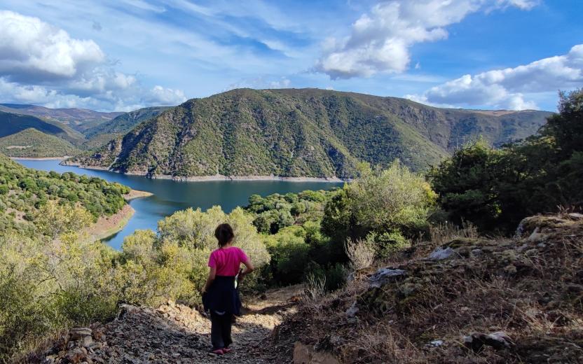
From Orroli, other itineraries depart between nature and archeology: the boat excursion on Lake Flumendosa and trekking to the Arrubiu nuraghe, covered in red lichens and unique with five towers; the visit to Sadali to admire the historic center and the zia Carmela house museum, mill, San Valentino waterfall and the Is Janas caves, shrouded in legends about the petrified fairy-witches inside; a trip to the Nuraghi valley of Isili, to Lake San Sebastiano, with the characteristic islet that houses a small church from which it takes its name, and in the woods between Santa Sofia and Villanova Tulo

How to get here

To reach the archaeological and botanical park of Su Motti, simply arrive at the historic center of Orroli via the panoramic road that overlooks the town and gives access to two 'memory trails', through which you can travel through time. The left one is easy, leading to the area of the domus de Janas (fairy houses), while the right one is challenging, leading to the Taccu Idda plateau, from where you can observe wonderful panoramas. In the park's woods, centuries-old holm oaks and dense Mediterranean scrub with the unmistakable scent of mastic and cistus.

Nuraghi and other places of history and archaeology

Geographical area Barbagia di Seulo Sarcidano

Su Motti (Orroli)

Un vero museo a cielo aperto, tra le attrazioni naturalistiche e archeologiche del Sarcidano, nella parte centro-meridionale della Sardegna: alla scoperta della preistoria isolana.

L’area è abitata dall’uomo fin dal Neolitico (3800 a.C.) ed è costellata da enormi massi di basalto eruttati dal vicino monte Pitziogu, vulcano spentosi in epoca quaternaria.

Nel parco qualche nuraghe monotorre e, soprattutto, una necropoli ipogeica di circa quindici domus de Janas, tombe pre-nuragiche scavate nelle pareti rocciose de sa Carona Arrubia e in grandi massi di basalto. Attorno alle grandi pietre la memoria popolare ha elaborato fantastici racconti, tra cui la vicenda del gigante malvagio Impolla, simbolo locale. Le leggende sono state tramandate oralmente e avvolgono di aura misteriosa i resti preistorici. 

Su Motti è un museo a cielo aperto che racconta anche di storia ottocentesca: la parcellizzazione dei boschi con i tipici muretti a secco di pietre basaltiche, che ha generato is tancas, appezzamenti di terra chiusi. I muretti sono testimoni dell’epoca della proprietà privata. La chiusura dei terreni, legittimata nel 1823, comportò anche i conflitti di classe fra contadini e pastori: da sempre il bestiame aveva pascolato nei terreni aperti, patrimonio della comunità.

Nelle vicinanze 

Imperdibile la grotta sa Ucca Manna (la bocca grande), dove sono convogliate le acque di sorgenti e torrenti vicini. La voragine è ricca di concrezioni e stalattiti lunghe e intatte. 

Da Orroli partono altri itinerari tra natura e archeologia: l’escursione in battello nel lago del Flumendosa e di trekking al nuraghe Arrubiu, ricoperto di licheni rossi e unico con cinque torri; la visita a Sadali per ammirare centro storico e casa museo di zia Carmela, mulino, cascata di san Valentino e le grotte Is Janas, avvolte da leggende sulle fate-streghe pietrificate all’interno; una gita alla valle dei nuraghi di Isili, al lago di san Sebastiano, col caratteristico isolotto che ospita una chiesetta da cui prende nome, e nei boschi tra Santa Sofia e Villanova Tulo.

How to get here

Per raggiungere il parco archeologico e botanico di su Motti basta arrivare al centro storico di Orroli passando per la strada panoramica che sovrasta l’abitato e dà accesso a due ‘percorsi della memoria’, attraverso cui viaggiare nel tempo. Agevole quello di sinistra, che conduce all’area delle domus de Janas (case delle fate), impegnativo quello di destra, che porta all’altopiano Taccu Idda, da dove osservare meravigliosi panorami. Nei boschi del parco lecci secolari e fitta macchia mediterranea con l’inconfondibile profumo di lentischio e cisto. 

Nuraghi e altri luoghi storico-archeologici

Geographical area Barbagia di Seulo Sarcidano