Nordic Walking
La camminata nordica o camminata con bastoni (in inglese nordic walking o pole walking) è attività fisica e sportiva che ben si coniuga con percorsi in bosco, in pianura o in vallate, lungo scogliere o spiagge. La Rete dei sentieri della Sardegna offre tantissime occasioni per cimentarsi nella camminata nordica...

Results

Oniferi, Sas Concas. The Necropolis
Access
The two archaeological sites visited by this simple tour can both be reached via the SS 128 road, directly from the village of Oniferi and following the signs for the SS 131. Leaving the last houses behind, you travel about 3.3 km and spot a tourist sign on the left indicating the necropolis. You will then park in a narrow space next to the main road.
Sas Concas
You pass a rudimentary wooden gate and descend along a gentle slope between some beautiful cork trees, passing a barely noticeable ford. On the left, a ridge of pyroclastites are clearly distinguishable, with a beautiful pinkish colour. The entire ridge is colonised by beautiful prickly pear plants, in sharp contrast to the orange lichens tenaciously attached to the rock: on these south-east-facing rocks the Neolithic inhabitants decided to find the final resting place for their loved ones, excavating one of the most extraordinary necropolises of their time. Wandering around the area, one can count up to twenty different tombs, often divided into several rooms. The domus de janas necropolis is also famous for the richness of the decorative elements in the burial chambers: ritual hearths, architectural elements relief carved and, above all, the mysterious graffiti symbolising stylised and upside-down men. The petroglyphs of Sas Concas are very similar to other depictions scattered in contemporary sites in Sardinia and represent an archaic and still mysterious symbolism: among the tombs of the necropolis, the best preserved ones are to be found in the large tomb of the hemicycle, preceded by a chamber excavated in the rock that is now largely eroded.
Nuraghe Ola
Once the visit to the necropolis is over, you can return to the car by continuing on the SS128, ignoring the detours for the SS 131 DCN and remaining on the old state road for about 3 km: on the left of the road, well signposted and visible, stands the magnificent Nuraghe Ola, at the centre of an area with a high density of archaeological monuments. The ancient nuragic tower, of a simple construction, can be reached by a short path from the car park. Immediately before the monument are two large huts, which have been the subject of archaeological investigation in recent times. The nuraghe was also recently restored. It consists of a large inner tholos chamber, where there are some alcoves, and a splendid intermural staircase that provides access to the upper floor. Here one notices a slab that closes the tholos and that, at the summer solstice, is sometimes removed to allow one to witness the suggestive phenomenon of the sun ray penetrating the darkness of the chamber below at midday. At the end of the visit, you can return to the village or visit the beautiful necropolis of Brodu, not far away, however its not signposted.
Tipologia itinerario
- Log in to post comments
Photogallery
Oniferi, Sas Concas. La necropoli
Accesso
I due siti archeologici visitati da questo semplice itinerario si raggiungono entrambi tramite la SS 128, direttamente dal paese di Oniferi e seguendo le indicazioni per la SS 131.
Lasciate le ultime case alle spalle si percorrono circa 3,3 km e si individua sulla sinistra un cartello turistico che indica la necropoli. Si posteggia così in un angusto spazio accanto alla statale.
Sas Concas
Si supera un rudimentale cancello fatto di legno e si scende un lieve declivio tra alcune belle sughere, superando un guado appena accennato. Sulla sinistra si distingue chiaramente un costone di piroclastiti, dal bel colore rosaceo. L’intero costone è colonizzato da belle piante di fichidindia, in forte contrasto con i licheni arancioni tenacemente attaccati alla roccia: su queste rocce esposte a sudest gli abitanti del Neolitico decisero di trovare l’estrema dimora per i propri cari, scavando una delle necropoli più straordinarie dei loro tempi.
Girovagando per la zona si possono contare fino a venti tombe diverse, articolate spesso al loro interno in più vani. La necropoli a domus de janas è celebre inoltre per la ricchezza degli elementi decorativi nei vani funerari: si individuano focolari rituali, elementi architettonici scolpiti in rilievo e soprattutto i misteriosi graffiti che simboleggiano uomini stilizzati e capovolti. I petroglifi di Sas Concas sono assai simili ad altre raffigurazioni sparse in siti coevi in Sardegna e rappresentano una simbologia arcaica e ancora misteriosa: tra le tombe della necropoli, quelli meglio conservati si trovano nell’ampia tomba dell’emiciclo, preceduta da un vano scavato nella roccia oggi in gran parte eroso.
Nuraghe Ola
Terminata la visita alla necropoli si può tornare all’auto proseguendo sulla SS128, ignorando le deviazioni per la SS 131 DCN e rimanendo sulla vecchia statale per circa 3 km: sulla sinistra della strada, ben segnalato e visibile, si staglia il magnifico Nuraghe Ola, al centro di un’area ad alta densità di monumenti archeologici.
L’antica torre nuragica, di tipo semplice, si raggiunge per un breve sentiero che si diparte dal parcheggio. Subito prima del monumento si incontrano due ampie capanne, oggetto di indagine archeologica in tempi recenti. Anche il nuraghe è stato recentemente restaurato. Si compone di un’ampia camera interna a tholos, dove sono presenti alcune nicchie, e da una splendida scala intermuraria che permette di accedere al piano superiore. Qui si nota una lastra che chiude la tholos e che, nel solstizio d’estate, viene talvolta rimossa per permettere di assistere al suggestivo fenomeno del raggio di sole che, a mezzogiorno, penetra nel buio della camera sottostante.
Terminata la visita si può rientrare al paese o visitare la bella necropoli di Brodu, poco distante, ma non segnalata
Tipologia itinerario
- Log in to post comments
Photogallery
Pathways Sa Sinipida - Su Suercone (B 440)
Pathways Sa Sinipida - Su Suercone (B 440)
Sentiero Italia (Stage Z20) Caserma Forestale Montarbu - Taquisara
Overview of the itinerary
Sentiero Italia runs the length of the island’s eastern side, covering its most important mountains, in 28 stages. Starting from the north: it flanks the Monte Limbara massif, crosses the limestones of Mont’Albo and Tuttavista, skirting the Gulf of Orosei, it crosses the Supramonte, Gennargentu and the Tacchi of Ogliastra and reaches Perdasdefogu. Further south, it passes through Armungia and the Gerrei sub-region. Lastly, it touches on the villages of Burcei and San Gregorio, continuing on the Sette Fratelli massif to the old prisons of Castiadas.
General information on Sentiero Italia (Grand Italian Trail)
Sentiero Italia, or Grand Italian Trail, as also explained on the official website, is a walking route that crosses the whole of Italy, using mainly but not exclusively “registered trails”.
In particular, in Sardinia, not all the stages of the Sentiero Italia of CAI (Italian Alpine Club) are made of trails already included in the registry of the Sardinia Trail Network (RES), either because they have not yet been tested and approved or simply because they cannot be registered as they do not meet the requirements. However, as a whole, the Sentiero Italia is the single longest walking route currently crossing Sardinia from the north (S. Teresa Gallura, stage Z 1) to the south (Castiadas, end of stage Z 28), touching on the most fascinating mountain areas in central-eastern Sardinia: the plateau of Buddusò, Tepilora, the Cedrino river valley, the ancient forests of Montes, Perda Liana and the regional forest of Montarbu, Monte Genis, and lastly the regional forest of Settefratelli (among the many crossed by the various stages of this long hiking itinerary).
Information on this stage of the trail
This stage starts at the Montarbu forest ranger station, a beautiful facility that the Forestas Agency makes available for overnight stays, booking a few days in advance with the relevant offices in Lanusei. The site is well equipped and here you can refill your water supply.
Walking along a dirt track, after about 800 m you will go through a gate and continue along a well-marked path until you have the railway on your right. Currently, the trenino verde (‘little green train’) that runs on that route is not operating due to maintenance work on the ‘su irtzioni’ bridge 800 m further ahead.
The path continues on a dirt track parallel to the railway, through the forest and after about 2 km, it emerges onto a large clearing with a picnic area and a pinnetto (traditional shepherd’s hut) in need of restoration. Further on, turning left for about 300 m, is the beautiful ‘funtana de sa berda’ spring. The path continues downhill, and with a couple of bends you will reach the 'Riu sa taula’ river. You can cross the river near a beautiful natural pool with a small waterfall. Continue uphill following the course of the river, which is full of interesting sights, including a large limestone formation in the shape of a tortoise. After about 1 km, you will arrive at another picnic area, in the ‘Tuvu Nieddu’ locality where there is an abundant spring. Cross the river and continue on a dirt track to the bar-restaurant where there is a beautiful picnic area (not open all year round) near which there is also a stop of the trenino verde (‘little green train’), called ‘Stazione di Niala’.
The Sentiero Italia continues to the left on a steep upward path with some paved sections. On the right, halfway up the slope, deviating from the trail, you will find a sculpture by famous artist Pinuccio Sciola depicting 6 limestone balls with a diameter of 80 cm. Here too you will find drinking water and a picnic area.
Returning to the route, still through the forest, you will come to a plateau where a dirt track leads, after about 5 km, to a fascinating archaeological site, ‘is Tostoinus’. Here you can admire a nuraghe (prehistoric stone fortress) and a tomb of the giants (megalithic communal tomb).
Further on, crossing a stream with a picturesque wooden bridge, you will reach a picnic area with drinking water and a very well maintained pinnetto (shepherd’s hut) that might be used as a camping facility in the future.
Leaving this area, which is very well maintained by Forestas, the ascent to the ridge begins. Here, the craggy and arid terrain makes the route particularly challenging during the summer. After about 4 km, the descent towards the end of the stage begins along a well-cleared and very scenic path that runs along the entire valley. Once in Gairo Taquisara, a picturesque small village with 300 inhabitants huddled at the bottom of a valley clothed in holm oaks and fir trees, you can stay overnight at a hotel or B&B or stop for refreshments at the bar.
A very beautiful, not very long, stage through the woods of ‘Tonneri di Ussasai-Seui’, a shaded area with several freshwater springs.
Informazioni utili
Tipologia itinerario
- Log in to post comments
Photogallery
Centro Servizi di Montarbu.jpg
Sentiero Montarbu - San Sebastiano.jpg
Strutture ricettive Montarbu.jpg
Ussassai, ponte in pietra tra Montarbu e Niala.jpg
Montarbu, muflone.jpg
Montarbu, pernice.jpg
Ussassai, ponte in pietra tra Montarbu e Niala.jpg
punta montarbu.jpg
Montarbu, daino.jpg
Trenino verde a Villanovatulo.jpg
Gairo, valle Taquisara.jpg
Gairo, panorama della frazione di Taquisara.jpg
Sentiero Italia (Tappa Z20) Caserma Forestale Montarbu - Taquisara
In sintesi
Il Sentiero Italia attraversa in lunghezza il settore orientale dell’isola toccandone i sistemi montuosi più rilevanti, in 28 tappe. Partendo da nord: tocca il massiccio del Monte Limbara, attraversa i calcari del Mont'Albo e del Tuttavista sfiorando il Golfo di Orosei, attraversa il Supramonte, il Gennargentu, i Tacchi dell’Ogliastra e giunge a Perdasdefogu. Più a sud, transita da Armungia e dalla subregione del Gerrei. Infine tocca l’abitato di Burcei e San Gregorio, per continuare nel massiccio dei Sette Fratelli fino alle vecchie carceri di Castiadas.
Informazioni generali sull'itinerario sentiero Italia
Il Sentiero Italia, come spiegato anche nel sito ufficiale, è un itinerario (o Cammino) lungo tutta l'Italia, che utilizza prevalentemente ma non esclusivamente "sentieri accatastati".
In particolare, in Sardegna, non tutte le tappe del Sentiero Italia del CAI coincidono con sentieri già inseriti nel catasto della Rete Escursionistica della Sardegna (RES), perché non hanno ancora superato le verifiche di percorribilità oppure semplicemente perché non possono essere accatastati non avendone i requisiti. Tuttavia, nel suo insieme, il Sentiero Italia rappresenta l'unica, la più grande dorsale escursionistica che attraversa attualmente la nostra Isola da nord (S. Teresa Gallura, tappa Z 1) a sud (Castiadas, fine tappa Z 28) toccando le aree montane della Sardegna centro-Orientale più affascinanti: l'altopiano di Buddusò, Tepilora, la valle del Cedrino, i boschi vetusti di Montes, Perda Liana e la foresta demaniale di Montarbu, il Monte Genis, e infine la foresta demaniale di Settefratelli (tra le tante attraversate dal lungo itinerario escursionistico a tappe).
Info sul percorso di questa tappa
Partenza dalla caserma della forestale di Montarbu, bellissimo posto che l'azienda Fo.Re.S.T.A.S. mette a disposizione per pernottamento, prenotando qualche giorno prima presso la direzione competente di Lanusei. Il sito è bene attrezzato, e tra le altre cose si può fare rifornimento d'acqua.
Si cammina su uno sterrato carrabile e dopo circa 800 metri si attraversa un cancello e si prosegue lungo un sentiero ben segnato fino ad avere la ferrovia alla nostra destra. Al momento il trenino verde che percorre quella tratta non è attivo per lavori di manutenzione sul ponte "su irtzioni" che si trova 800 metri più avanti.
Il sentiero prosegue su una sterrata parallela alla ferrovia, in mezzo al bosco e dopo circa 2 km, sbuca in un largo spiazzo dove c'è un area picnic ed un pinnetto da restaurare. Più avanti, deviando a sinistra per circa 300 metri, c'è la bella sorgente "funtana de sa berda". Il sentiero prosegue in discesa, e con un paio di tornanti si arriva al fiume "Riu sa taula”, lo si attraversa nei pressi di una bella piscina naturale con una piccola cascata. Si prosegue in salita lungo il corso del fiume ricco di particolarità, tra cui una grande formazione calcarea a forma di testuggine. Dopo circa 1 km si arriva ad una altra area picnic, in località "Tuvu Nieddu" dove sgorga una ricca sorgente d'acqua. Si attraversa il fiume e si prosegue su una sterrata carrabile fino al bar ristorante dove si trova una bella area attrezzata, non aperta tutto l'anno, nei cui pressi si trova anche una fermata del trenino verde, chiamata "Stazione di Niala”.
Il Sentiero Italia prosegue sulla sinistra in una salita ripida a tratti cementata. Sulla destra, a metà salita, deviando dal sentiero, c'è un opera di un famoso artista Pinuccio Sciola raffigurante 6 palle di calcare del diametro di 80 cm, anche qui c'è acqua e un'area picnic.
Rientrando sul percorso, sempre in mezzo al bosco, si arriva su un altopiano dove una sterrata carrabile ci porta, dopo circa 5 km, ad una zona archeologica di particolare interesse "is Tostoinus". Si possono ammirare un nuraghe ed una tomba dei giganti.
Più avanti, attraversando un rio con un ponte in legno molto bello, si raggiunge un area picnic con acqua ed un pinnetto molto bene tenuto che in futuro si potrebbe adibire a bivacco.
Uscendo da quest'area molto curata da Fo.Re.S.T.A.S., inizia la salita per raggiungere la cresta. Qui il terreno montuoso ed arido rende il percorso particolarmente impegnativo durante l'estate. Dopo circa 4 km inizia la discesa verso il fine tappa lungo un sentiero ben pulito e molto panoramico, che costeggia tutta la vallata. Arrivati a Gairo Taquisara, piccolo e bellissimo borgo con 300 abitanti situato ai piedi di una vallata piena di lecci e abeti, è possibile pernottare presso hotel o B&B o rifocillarsi al bar.
Tappa molto bella, non molto lunga, in mezzo ai boschi del "Tonneri di Ussasai-Seui", ombreggiata e ben fornita di sorgenti.
Informazioni utili
Lungo il percorso non sarà sempre presente la copertura telefonica
Tipologia itinerario
- Log in to post comments
Photogallery
Centro Servizi di Montarbu.jpg
Sentiero Montarbu - San Sebastiano.jpg
Strutture ricettive Montarbu.jpg
Ussassai, ponte in pietra tra Montarbu e Niala.jpg
Montarbu, muflone.jpg
Montarbu, pernice.jpg
Ussassai, ponte in pietra tra Montarbu e Niala.jpg
punta montarbu.jpg
Montarbu, daino.jpg
Trenino verde a Villanovatulo.jpg
Gairo, valle Taquisara.jpg
Gairo, panorama della frazione di Taquisara.jpg

Pathways Ponte di Gusana - Ovodda (T 531)
Sarule, Gonare. The mountain of the spirit
Access
From the inhabited centre of Sarule, go in the direction of the village cemetery, then continue along the main road until an clear and obvious crossroads dominated by the three pointed peaks of Monte Gonare. Take a left, following the signs for the mountain and continuing to climb on the tarmac road until the next crossroads, where you keep to the right, travelling for a few hundred metres and parking in a large clearing where the road ends, near some buildings that serve as shelters for the worshippers during the festivities.
The via Crucis: The Way of the Cross
The sanctuary of Gonare is located near the border between the municipalities of Sarule and Orani and its festivity is particularly ardent celebration The ancient church is said to have been built at the behest of Gonario di Torres to thank the Virgin Mary for having saved him during a storm at sea, but its dominant position highlights a geopolitical and at the same time ascetic intention. From the clearing, a well-marked path can be seen on the left, the same one where Via Crucis take place, leading to the sanctuary, where every step is marked by the passage of pilgrims and cloaked in legends and stories. You gradually gain height, surrounded by a beautiful wood of Holm oaks lashed by the wind. In spring, extraordinary blooms of lilies and peonies enrich the route.
The church
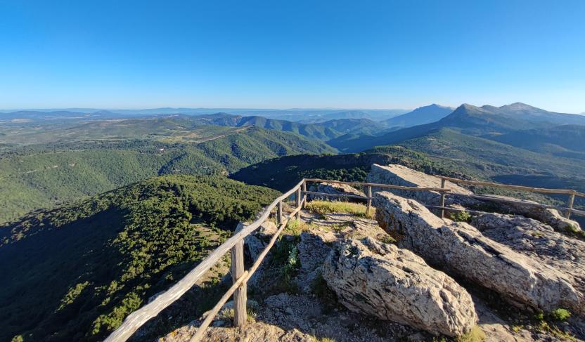
A couple of narrow hairpin bends make up the steepest part of the climb, the final one, now dominated by the church. The beautiful medieval building was extended several times and occupies the summit of the mountain, located at an altitude of just under 1100 metres. From the church one can enjoy a vast panorama that embraces the two coasts of Sardinia and a large part of the central and northern regions of the island. One can also admire the sunrise rising over the Gulf of Orosei and the sunset sinking into the waters of the Gulf of Oristano, offshore from Sinis, while the Gennargentu closes the panorama to the south and the jagged peaks of the Limbara mark the last visible places to the north. A door of the church is always open and allows entry to anyone who reaches the summit to grant anyone a prayer, after which they return to their cars by the path they took.
Tipologia itinerario
- Log in to post comments