Accessible trails
Sentieri per tutti...in questa categoria rientrano i sentieri progettati o riadattati perchè il contatto con l'ambiente naturale sia sempre di stimolo al miglioramento della vita personale di chiunque, con attenzione alle condizioni di disabilità motoria, sensoriale o della sfera psichica e relazionale...

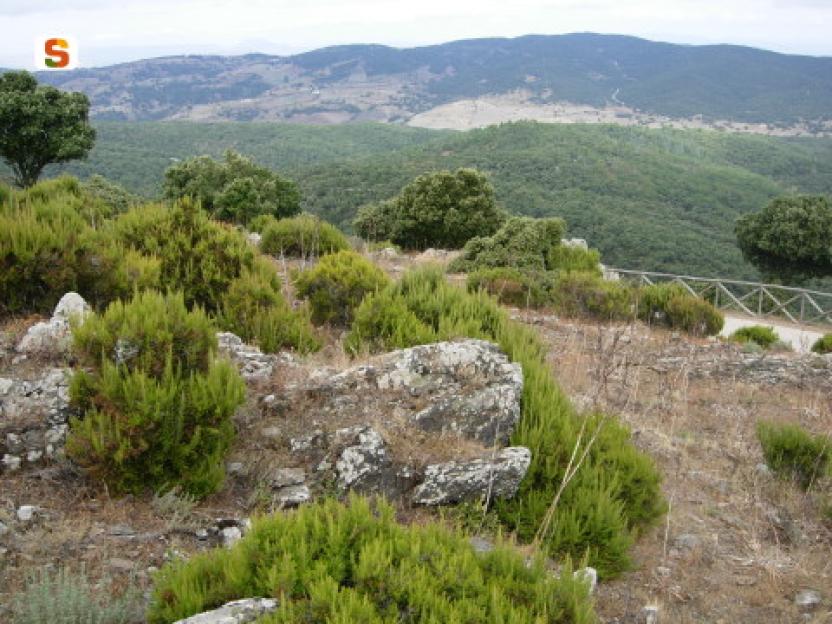
Image credits Sardegna Digital Library Regione Sardegna
Results
CMSB - STAGE 03 – FROM MASUA TO BUGGERRU
This is one of the most challenging stages of the Trail, especially because of the elevation gains.
The effort is compensated for by the extraordinary beauty of the coastal landscape and by the richness of the geological heritage:
In the area of Canal Grande, you can observe the fossil remains of the first life forms that appeared on the planet.
Also of interest are the examples of industrial archaeology: from the old railway, to the loading plant in Cala Domestica, up to the large excavation of Planu Sartu.
In Cala Domestica, you can stop at the Oasi Beach kiosk; the services offered are: catering, transfer service by jeep or dinghy, and guided tours. It is open daily until November 3rd, afterwards only on weekends.
For those wishing to undertake a less challenging route, an alternative route is available which excludes the stretch overlooking the cliffs between Porto Flavia and Cala Domestica.
Safety and useful tips
Some passages, particularly along the panoramic route after passing the Cantina Belvedere, are exposed to falling from above - do not lean towards the exposed part and, if necessary, keep to the centre or to the upstream side of the roadway.
While walking this panoramic route, both along the climb towards Monte Nai and in the area of the ruins of the Cantina Belvedere, you will see open excavations of old mineral deposits - do not leave the route to visit such areas, always remain on the path.
The stage is challenging in terms of both length and elevation gains, therefore it is advisable to prepare adequately.
At the end of the stage, you will pass through the asphalted roads of the village of Buggerru, make sure to pay attention to vehicular traffic.
Informazioni utili
This is one of the most challenging stages of the Camino especially due to the significant differences in altitude encountered along the way. The route has a length of 19.3 km which can be covered in 7 hours and an uphill difference in altitude of 887 m and a downhill difference of 889 m.
FOR UPDATED INFORMATION, CONSULT THE STAGE SHEET ON THE OFFICIAL WEBSITE
Tipologia itinerario
- Log in to post comments
Links
Photogallery
CMSB - TAPPA 3: DA MASUA A BUGGERRU
L'itinerario
Da Masua si raggiunge la località Canal Grande dove è possibile osservare alcuni reperti fossili che rappresentano alcune tra le prime forme di vita apparse sul pianeta.
Di notevole interesse anche l’archeologia industriale, dalla vecchia ferrovia che giunge all’impianto di caricamento di Cala Domestica, al grande scavo di Planu Sartu.
A Cala Domestica segnaliamo la presenza del chiosco Oasi Beach che offre i servizi di ristorazione, servizio transfer con jeep o gommone e tour guidati. Il chiosco è aperto tutti i giorni fino al 3 novembre e in seguito solo nei i weekend.
Per chi volesse intraprendere un percorso meno impegnativo, è disponibile un percorso alternativo che esclude il tratto a picco sulle falesie tra Porto Flavia e Cala Domestica
Informazioni utili
Questa è una delle più impegnative tappe del Cammino soprattutto a causa dei notevoli dislivelli che si incontrano durante il tragitto. Il percorso ha una lunghezza di 19,3 km percorribili in 7 ore e un dislivello in salita di 887 m e uno in discesa di 889 m.
La fatica è tuttavia compensata dalla straordinaria bellezza del paesaggio costiero e dalla ricchezza del patrimonio geologico:
PER LE INFORMAZIONI AGGIORNATE, CONSULTA LA SCHEDA DELLA TAPPA, SUL SITO UFFICIALE
Il Cammino Minerario di Santa Barbara
Si tratta del primo, tra i cammini sardi, ad essere stato iscritto al registro istituito dalla Regione Sarda nel 2012 con DGR48/9 ("Registro dei cammini di Sardegna, degli itinerari religiosi e dello spirito"). Attualmente è gestito dall'omonima Fondazione.
LA STORIA DEL PROGETTO
L’idea di costruire un itinerario nell’area più estesa e rappresentativa del Parco Geominerario Storico Ambientale della Sardegna, il Sulcis-Iglesiente-Guspinese, riscoprendo gli antichi cammini minerari oggi in gran parte abbandonati, è nata dai volontari dell’Associazione ONLUS Pozzo Sella Per il Parco Geominerario a seguito della grande partecipazione dei cittadini alle escursioni organizzate dalla stessa associazione dopo aver reso fruibili numerosi percorsi minerari.
Con il Cammino Minerario di Santa Barbara si vuole perseguire l’obiettivo di tramandare la memoria degli uomini che nei secoli e nei millenni passati hanno realizzato e percorso gli antichi cammini minerari con il piacere di riscoprire a passo lento la bellezza del territorio.
Un Protocollo d’intesa è stato sottoscritto tra i Comuni di Iglesias, Buggerru, Fluminimaggiore, Arbus, Guspini, Gonnosfanadiga, Villacidro, Domusnovas, Musei, Villamassargia. Narcao, Nuxis, Santadi, Piscinas, Giba, Masainas, San Giovanni Suergiu, Sant’Antioco, Carbonia e Gonnesa, le Diocesi di Iglesias e di Ales Terralba, le Province di Carbonia Iglesias e del Medio Campidano, il Consorzio del Parco Geominerario Storico Ambientale della Sardegna, l’ANCI SARDEGNA e l’Associazione Pozzo Sella: si tratta di un partenariato per la costruzione e la gestione dell’itinerario storico, culturale, ambientale e religioso denominato “Cammino Minerario di Santa Barbara”.
PER MAGGIORI INFORMAZIONI, DETTAGLI E INFO AGGIORNATE SULLE TAPPE
Si consiglia di consultare il sito ufficiale del cammino: www.camminominerariodisantabarbara.org/
Tipologia itinerario
- Log in to post comments
Links
Photogallery
Roadbook
In località Canal Grande si possono osservare alcuni reperti fossili che testimoniano alcune tra le prime forme di vita apparse sul pianeta.
Di notevole interesse anche l’archeologia industriale, dalla vecchia ferrovia che giunge all’impianto di caricamento di Cala Domestica, al grande scavo di Planu Sartu.
Sentiero Italia (Stage Z19) Terra Ona - Caserma Forestale Montarbu
Overview of the itinerary
Sentiero Italia runs the length of the island’s eastern side, covering its most important mountains, in 28 stages. Starting from the north: it flanks the Monte Limbara massif, crosses the limestones of Mont’Albo and Tuttavista, skirting the Gulf of Orosei, it crosses the Supramonte, Gennargentu and the Tacchi of Ogliastra and reaches Perdasdefogu. Further south, it passes through Armungia and the Gerrei sub-region. Lastly, it touches on the villages of Burcei and San Gregorio, continuing on the Sette Fratelli massif to the old prisons of Castiadas.
General information on Sentiero Italia (Grand Italian Trail)
Sentiero Italia, or Grand Italian Trail, as also explained on the official website, is a walking route that crosses the whole of Italy, using mainly but not exclusively “registered trails”.
In particular, in Sardinia, not all the stages of the Sentiero Italia of CAI (Italian Alpine Club) are made of trails already included in the registry of the Sardinia Trail Network (RES), either because they have not yet been tested and approved or simply because they cannot be registered as they do not meet the requirements. However, as a whole, the Sentiero Italia is the single longest walking route currently crossing Sardinia from the north (S. Teresa Gallura, stage Z 1) to the south (Castiadas, end of stage Z 28), touching on the most fascinating mountain areas in central-eastern Sardinia: the plateau of Buddusò, Tepilora, the Cedrino river valley, the ancient forests of Montes, Perda Liana and the regional forest of Montarbu, Monte Genis, and lastly the regional forest of Settefratelli (among the many crossed by the various stages of this long hiking itinerary).
Information on this stage of the trail
This is a medium-length stage that initially retraces a short section of stage Z18 and then continues in a southerly direction on a dirt track that leads to Cuile Gidinis and, from there, in a south-easterly direction until it arrives at the road and the bridge that crosses the Rio Pirincanes stream. Travel along this road for a short distance before turning, after a couple of bends, in an easterly direction, then south, towards Perda Liana, which you will reach on the path that begins at the car park, after crossing road SS 389.
Follow the clearly visible path, keeping to the right at the next fork (the path to the left rejoins with this one after a much longer loop). The Perda Liana rock tower, a natural monument and symbol of the Ogliastra area, is visible from all sides as it stands on top of a hill. According to local legend, it once marked the entrance to the underworld.
Leaving Perda Liana behind you, continue in a southerly direction. After a bend to the north, the trail then heads south-west passing by Su Stampu, an impressive sinkhole about 50 m deep (N39.89595° E9.39277°).
Continue, still at high elevation, along the valley of the Flumendosa river to reach the summit of Pizzu Margiani Pubusa (1325 m asl) where there is a fire lookout.
From this summit, the descent towards the Montarbu stop point (874 m asl) begins, on a beautiful path through the forest in a southerly direction (at this fork N39.88223° E9.38695° turn right) with several springs along the path, running alongside a stream which in Spring has several small waterfalls.
This is a very scenic stage, particularly after passing Perda Liana, but it is fairly challenging.
Notes
At the Montarbu stop point there is a Fo.Re.S.T.A.S. station, where it is currently possible to stay overnight pitching a tent.
Informazioni utili
Tipologia itinerario
- Log in to post comments
Photogallery
Sentiero Italia (Tappa Z19) Terra Ona - Caserma Forestale Montarbu
In sintesi
Il Sentiero Italia attraversa in lunghezza il settore orientale dell’isola toccandone i sistemi montuosi più rilevanti, in 28 tappe. Partendo da nord: tocca il massiccio del Monte Limbara, attraversa i calcari del Mont'Albo e del Tuttavista sfiorando il Golfo di Orosei, attraversa il Supramonte, il Gennargentu, i Tacchi dell’Ogliastra e giunge a Perdasdefogu. Più a sud, transita da Armungia e dalla subregione del Gerrei. Infine tocca l’abitato di Burcei e San Gregorio, per continuare nel massiccio dei Sette Fratelli fino alle vecchie carceri di Castiadas.
Informazioni generali sull'itinerario sentiero Italia
Il Sentiero Italia, come spiegato anche nel sito ufficiale, è un itinerario (o Cammino) lungo tutta l'Italia, che utilizza prevalentemente ma non esclusivamente "sentieri accatastati".
In particolare, in Sardegna, non tutte le tappe del Sentiero Italia del CAI coincidono con sentieri già inseriti nel catasto della Rete Escursionistica della Sardegna (RES), perché non hanno ancora superato le verifiche di percorribilità oppure semplicemente perché non possono essere accatastati non avendone i requisiti. Tuttavia, nel suo insieme, il Sentiero Italia rappresenta l'unica, la più grande dorsale escursionistica che attraversa attualmente la nostra Isola da nord (S. Teresa Gallura, tappa Z 1) a sud (Castiadas, fine tappa Z 28) toccando le aree montane della Sardegna centro-Orientale più affascinanti: l'altopiano di Buddusò, Tepilora, la valle del Cedrino, i boschi vetusti di Montes, Perda Liana e la foresta demaniale di Montarbu, il Monte Genis, e infine la foresta demaniale di Settefratelli (tra le tante attraversate dal lungo itinerario escursionistico a tappe).
Info sul percorso di questa tappa
Tappa di media lunghezza che ripercorre inizialmente un breve tratto della tappa Z18 per poi proseguire in direzione S su sterrata che porta al cuile Gidinis e da questo in direzione sud-est per arrivare alla strada ed al ponte che attraversa il rio Pirincanes. Strada che percorriamo per un breve tratto per poi deviare, dopo un paio di tornanti, in direzione est, successivamente a sud, verso Perda Liana che raggiungiamo sul sentiero che inizia al parcheggio, dopo aver superato la SS 389.
Il sentiero ben visibile lo percorriamo tenendo la destra nel successivo bivio (il percorso a sinistra si ricongiunge dopo aver fatto un giro molto più ampio). Il torrione di Perda Liana, monumento naturale e simbolo dell’Ogliastra è visibile a 360° in quanto situato sulla sommità di un rilievo. Nelle legende popolari divenne l’ingresso degli inferi.
Lasciato il torrione alle nostre spalle continuiamo in direzione sud, fatto un’ansa con direzione nord riprendiamo verso sud-ovest per andare a vedere la voragine Su Stampu, inghiottitoio profondo circa 50 metri (N39.89595° E9.39277°).
Si prosegue, sempre in quota, costeggiando la valle del fiume Flumendosa per giungere alla sommità di Pizzu Margiani Pubusa (1325 slm) dove è presente una vedetta antincendio.
Da questa vetta inizia la discesa verso il posto tappa di Montarbu (874 slm) percorrendo in direzione sud un bel sentiero immerso nel bosco (in questo bivio N39.88223° E9.38695° prendere verso destra) con diverse sorgenti che si trovano lungo il sentiero costeggiando un torrente con numerose cascatelle presenti nel periodo primaverile.
Tappa molto panoramica, in particolare nella parte successiva al torrione, ma abbastanza impegnativa.
Note
Nel posto tappa Montarbu è presente una caserma dell'Agenzia Regionale Fo.Re.S.T.A.S. dove al momento è possibile il pernottamento con tenda.
Tipologia itinerario
- Log in to post comments
Photogallery
Sentiero Italia (Stage Z25) Armungia - Niu 'e S'Achili
Overview of the itinerary
Sentiero Italia runs the length of the island’s eastern side, covering its most important mountains, in 28 stages. Starting from the north: it flanks the Monte Limbara massif, crosses the limestones of Mont’Albo and Tuttavista, skirting the Gulf of Orosei, it crosses the Supramonte, Gennargentu and the Tacchi of Ogliastra and reaches Perdasdefogu. Further south, it passes through Armungia and the Gerrei sub-region. Lastly, it touches on the villages of Burcei and San Gregorio, continuing on the Sette Fratelli massif to the old prisons of Castiadas.
General information on Sentiero Italia (Grand Italian Trail)
Sentiero Italia, or Grand Italian Trail, as also explained on the official website, is a walking route that crosses the whole of Italy, using mainly but not exclusively “registered trails”.
In particular, in Sardinia, not all the stages of the Sentiero Italia of CAI (Italian Alpine Club) are made of trails already included in the registry of the Sardinia Trail Network (RES), either because they have not yet been tested and approved or simply because they cannot be registered as they do not meet the requirements. However, as a whole, the Sentiero Italia is the single longest walking route currently crossing Sardinia from the north (S. Teresa Gallura, stage Z 1) to the south (Castiadas, end of stage Z 28), touching on the most fascinating mountain areas in central-eastern Sardinia: the plateau of Buddusò, Tepilora, the Cedrino river valley, the ancient forests of Montes, Perda Liana and the regional forest of Montarbu, Monte Genis, and lastly the regional forest of Settefratelli (among the many crossed by the various stages of this long hiking itinerary).
Information on this stage of the trail
Due to flood damage in 2008, the path no longer follows the Riu Tolu gorge, but heads towards Laccu Muttaxeddu and then passes along the old miners’ road bordered by dry-stone walls.
Once at the Su Suergiu mine, head for the Rio Tolu forest towards Su Niù and S’Achili, in the municipality of San Nicolò Gerrei, where you can stay overnight.
This is an easy stage but it is about 20 km long.
Informazioni utili
Tipologia itinerario
- Log in to post comments
Photogallery
Armungia.-Caratteristiche-conformazioni-rocciose.jpg
Armungia.-Il-nuraghe-XIV-sec.-a.C.-ca.-al-centro-del-paese.jpg
Armungia.-Museo-etnografico-Sa-Domu-de-is-Ainas.jpg
Gerrei, panorama 3.jpg
Gerrei, panorama (2).jpg
Villasalto, miniera Su Suergiu 2.jpg
Villasalto, miniera Su Suergiu.jpg
Panorama dalla miniera di Su Suergiu.jpg
Villasalto, sughera in località Su Suergiu.jpg
Sorgente presso Rio Tolu.jpg
Panorama su Armungia.jpg
Sentiero Italia (Tappa Z25) Armungia - Niu 'e S'Achili
In sintesi
Il Sentiero Italia attraversa in lunghezza il settore orientale dell’isola toccandone i sistemi montuosi più rilevanti, in 28 tappe. Partendo da nord: tocca il massiccio del Monte Limbara, attraversa i calcari del Mont'Albo e del Tuttavista sfiorando il Golfo di Orosei, attraversa il Supramonte, il Gennargentu, i Tacchi dell’Ogliastra e giunge a Perdasdefogu. Più a sud, transita da Armungia e dalla subregione del Gerrei. Infine tocca l’abitato di Burcei e San Gregorio, per continuare nel massiccio dei Sette Fratelli fino alle vecchie carceri di Castiadas.
Informazioni generali sull'itinerario sentiero Italia
Il Sentiero Italia, come spiegato anche nel sito ufficiale, è un itinerario (o Cammino) lungo tutta l'Italia, che utilizza prevalentemente ma non esclusivamente "sentieri accatastati".
In particolare, in Sardegna, non tutte le tappe del Sentiero Italia del CAI coincidono con sentieri già inseriti nel catasto della Rete Escursionistica della Sardegna (RES), perché non hanno ancora superato le verifiche di percorribilità oppure semplicemente perché non possono essere accatastati non avendone i requisiti. Tuttavia, nel suo insieme, il Sentiero Italia rappresenta l'unica, la più grande dorsale escursionistica che attraversa attualmente la nostra Isola da nord (S. Teresa Gallura, tappa Z 1) a sud (Castiadas, fine tappa Z 28) toccando le aree montane della Sardegna centro-Orientale più affascinanti: l'altopiano di Buddusò, Tepilora, la valle del Cedrino, i boschi vetusti di Montes, Perda Liana e la foresta demaniale di Montarbu, il Monte Genis, e infine la foresta demaniale di Settefratelli (tra le tante attraversate dal lungo itinerario escursionistico a tappe).
Info sul percorso di questa tappa
A causa dei danni provocati dall’alluvione del 2008, il percorso non segue più la gola del Riu Tolu, ma verso Laccu Muttaxeddu e poi lungo la strada dei minatori delimitata da muretti a secco.
Giunti alla miniera di Su Suergiu si procede verso la foresta del rio Tolu verso Su Niù e S’Achili, nel Comune di San Nicolò Gerrei, dove si può pernottare.
Si tratta di una tappa facile ma lunga una ventina di chilometri.
Informazioni utili
Lungo il percorso non sarà sempre presente la copertura telefonica
Tipologia itinerario
- Log in to post comments
Photogallery
Armungia.-Caratteristiche-conformazioni-rocciose.jpg
Armungia.-Il-nuraghe-XIV-sec.-a.C.-ca.-al-centro-del-paese.jpg
Armungia.-Museo-etnografico-Sa-Domu-de-is-Ainas.jpg
Gerrei, panorama 3.jpg
Gerrei, panorama (2).jpg
Villasalto, miniera Su Suergiu 2.jpg
Villasalto, miniera Su Suergiu.jpg
Panorama dalla miniera di Su Suergiu.jpg
Villasalto, sughera in località Su Suergiu.jpg
Sorgente presso Rio Tolu.jpg
Panorama su Armungia.jpg
Carta 1. Baronie e Montalbo
About the territory
The territory of the Baronie runs from the limestone chain of Montalbo to the massif of Tuttavista, an area marked by streams and rivers such as the Isalle and the Cedrino and wide alluvial plains.
Map No. 1 (Baronie) suggests an itinerary in the Baronie territory, based on three trails.
In this aera, the Montalbo range is especially important for its natural heritage. Thanks to its environmental characteristics and good conservation status, it is home to a number of rare and endemic animal and plant species, including the Santolina corsica, the Lactuca longidentata, the Monte Albo cave salamander, the red-billed chough, the golden eagle and the mouflon.
Along the walking routes proposed in this itinerary, you can also find ancient charcoal pits and make a stop at the old sheepfolds (pinnettos). You will also enjoy the stunning views offered by the numerous stretches at altitudes above 900m a.s.l. on the ridges of the Montalbo massif.
The Pinnetos
The Pinnettos are original stone and wood huts which for many centuries were the solitary shelters of the Sardinian shepherds, around which they raised their goats, sheep and pigs. These huts are a testimonial to the old life of the shepherds, governed by the rhythms of nature and the seasons. The main building, called Su Pinnettu or Su Barracu, according to the area, consists of a dry-stone circular wall surmounted by a cone-shaped roof made of holm oak and juniper planks and branches, lined with smaller branches and leaves. Inside, it has a central fireplace, probably very similar to the fireplaces of the ancient nNuragic huts, called Su Foghile, while a series of shelves along the wall served to store the shepherds’ tools and the products of their work, such as wheels of cheese and hams. Su Pinnettu is often flanked by a smaller hut used as a toolshed, surrounded by a dry stone pen for holding the sheep, called Sa corte; the pen also included smaller enclosures, called Cherinas, used to hold baby goats. The pigsty, on the other hand, consisted of a low rectangular hut with an enclosure.
Montalbo
A limestone bastion about 20 km long, Monte Albo with its distinctive long and imposing profile, overlooks the historical territory of the Baronie. This limestone massif dates back to the Mesozoic and is rich in white stone ravines and caves. Characterised by steep slopes, cut by deep ravines, it reaches its maximum height with the peaks of Punta Catirina and Punta Turuddò, which exceed 1050 m. a.s.l. The entire area preserves and maintains significant examples of the Mediterranean maquis and local endemic flora. The area is inhabited by many animal species such as the Montalbo cave salamander, the mouflon, the red-billed chough, the common raven, the wildcat and the marten. At certain times of the year, the golden eagle nests there. An impressive sight is the sinkhole of Tumba ’e Nurrai, located between Punta Catirina and Punta Turuddò. In the imposing summit of Punta Catirina opens the cave of Janna Manna, about 200 m long, which lies at a short distance from that of Omines Agrestes. On the Monte Albo, human presence has been documented since the Neolithic period, with the domus de janas of Mannu ‘e Gruris, rock-cut chamber tombs with a carved door frame and four cells. Throughout the massif there are many caves that were used in prehistoric times as natural shelters. One of these is the cave of Bona Fraule, in the municipality of Siniscola, where valuable objects such as swords and iron daggers have been found, suggesting that it was used as a place of worship. Monte Albo falls mainly within the municipalities of Siniscola and Lula, which can be reached via State Road 131 D.C.N. and following the road signs from there.
Allegati
Itinerary roadbook
Tipologia itinerario
Photogallery
Carta 1. Baronie e Montalbo
Premessa
Questo percorso rappresenta la concatenazione di 3 vecchi sentieri realizzati nel 2010, per i quali l'iscrizione nel catasto sentieri della R.E.S. potrebbe produrre delle variazioni al tracciato, che sono in corso. Resta tuttavia un discreto itinerario, impegnativo e lungo, per visitare il Montalbo
Inquadramento territoriale
Il territorio delle Baronie spazia dalla catena calcarea del Montalbo sino al massiccio del Tuttavista, in un’area caratterizzata da corsi d’acqua come l’Isalle e il Cedrino e vaste pianure alluvionali.
Nella carta n.1 (Baronie) è proposto un itinerario sul territorio delle Baronie, basato su tre sentieri.
In questo contesto il Montalbo riveste un ruolo di fondamentale importanza dal punto di vista naturalistico. Per le sue caratteristiche ambientali e per il suo buono stato di conservazione ospita numerose specie di flora e fauna rare ed endemiche tra cui la Santolina corsica, la Lactuca longidentata, il geotritone del Montalbo, il gracchio corallino, l’aquila reale e il muflone.
Lungo i sentieri proposti in questo itinerario, è possibile inoltre osservare i segni della presenza dei carbonai e sostare presso gli antichi ovili (pinnettos). Da segnalare, infine, le viste mozzafiato offerte dai numerosi tratti oltre quota 900m s.l.m. sulle creste del Montalbo.
I PINNETTOS
I Pinnettos sono originali costruzioni in pietra e legno che per secoli sono state le dimore solitarie dei pastori della Sardegna, attorno alle quali venivano allevati capre, pecore e maiali. Queste strutture ricordano quella che un tempo era la vita dei pastori, governata dal ritmo della natura e delle stagioni.
La struttura principale, chiamata Su Pinnettu o Su Barraccu, in base alla variante linguistica, era composta da un muro perimetrale a secco e sormontata da un tetto a cono rovesciato composto da travi, rami di leccio e ginepro, foderato con frasche e foglie. L'interno del Pinnettos è costituito da un focolare centrale, probabilmente su esempio del focolare delle capanne nuragiche, chiamato Su foghile, mentre alcuni ripiani laterali, servivano al pastore per riporre gli strumenti di lavoro e i prodotti tipici lavorati, come le forme di pecorino e il prosciutto. I Pinnettos sono spesso affiancati ad una piccola costruzione, utilizzata come ripostiglio per gli attrezzi più ingombranti, e da un recinto per il gregge chiamato Sa corte, a sua volta affiancato da piccoli spazi, chiamati Cherinas, utilizzati per il ricovero dei capretti. La porcilaia, invece, aveva la forma di una casetta rettangolare dotata di un recinto.
IL MONTALBO
Bastione calcareo lungo una ventina di chilometri, il Monte Albo ha una tipica forma allungata e imponente che domina il territorio storico delle Baronie. Il rilievo calcareo risale al mesozoico ed è ricco di bianche gole e grotte. Caratterizzato da versanti verticali, tagliato da burroni profondi, raggiunge la massima altezza con le vette di Punta Catirina e Punta Turuddò che superano i 1050 metri. Tutta la zona conserva e mantiene esempi significativi della macchia mediterranea ed endemismi tipici. Il territorio è abitato da diverse specie faunistiche come, il geotritone del Montalbo il muflone, il gracchio corallino, il corvo imperiale, il gatto selvatico e la martora. In alcuni periodi dell'anno vi nidifica anche l'aquila reale. Notevole è l'inghiottitoio di Tumba ‘e Nurrai che si trova fra Punta Catirina e Punta Turuddò.
Nell'imponente rilievo di Punta Catirina si apre la grotta di Janna Manna, lunga circa 200 m, che si trova a poca distanza da quella di Omines Agrestes. Nel Monte Albo è documentata la presenza umana a partire dal neolitico, con la domus de janas di Mannu 'e Gruris che presenta una porta scalpellata con quattro celle interne. Diverse sono le grotte presenti in tutto il massiccio che sono state utilizzate dall'uomo come rifugi naturali. Una di queste è la grotta di Bona Fraule nel comune di Siniscola, dove il ritrovamento di materiale pregiato come spade e pugnali di ferro fa pensare ad una sua utilizzazione come luogo di culto. Il Monte Albo ricade principalmente nei comuni di Siniscola e Lula, questi sono raggiungibili percorrendo la Strada statale n. 131 D.C.N. e seguendo le relative indicazioni.
Allegati
Itinerary roadbook
Tipologia itinerario
Contiene carte
Spento