The archaeological site of Biru’e Concas is located on the slopes of the hill of the same name, in the area known as Coa’ e sa Mandara, in the south-western part of the municipality of Sorgono. The complex stands in a particularly strategic point in central Sardinia, almost acting as a crossroads between the mountain communities of the Barbagie and the agricultural communities of the Tirso Valley.
The archaeological complex is characterized by a long history of human occupation; the earliest evidence of human presence in the area dates back to the Final Neolithic, with the Ozieri culture. The site shows a greater concentration of archaeological data throughout the Copper Age, with the presence of the Sardinian Filigosa/Abealzu facies and the external Monte Claro facies. Human activity continues during the Bronze Age.
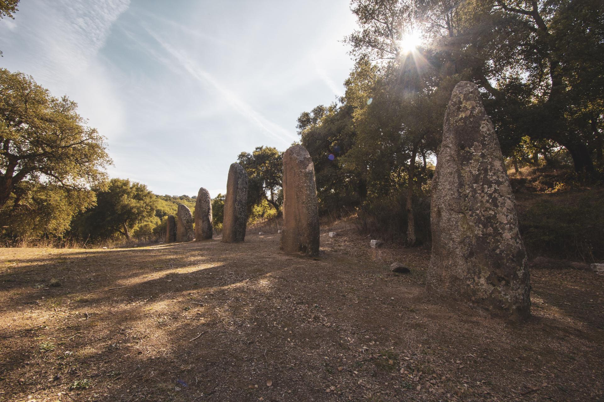
It is also characterized by the presence of various types of monuments, attributable mostly to the pre-Nuragic period. Among the monuments, the enormous quantity of menhirs scattered over the entire hill stands out: around 150 in total, divided into aniconic menhirs, proto-anthropomorphic menhirs, anthropomorphic menhirs, and an armed statue-menhir. Some menhirs were repositioned in modern times and gave rise to the two alignments that now characterize the site: the western alignment and the eastern alignment.
The complex is also notable for the presence of boulders with cup-marks, decorations with probable socio-symbolic purposes (some hypotheses interpret the hollows as the result of multiple ritual grindings). The menhirs and the boulders with cup-marks can be dated to the final phases of the Neolithic and the early Copper Age. Also attributable to the Copper Age are the remains of an imposing megalithic enclosure, currently under study. Finally, on the top of the hill are the remains of the nuraghe of the same name, datable to the Middle Bronze Age.
Biru ‘e Concas Archaeological Site Informations
Statue-Menhir: the statue-menhir of Biru’e Concas has a sub-ogival outline with an arched top and a plano-convex cross-section. The monolith displays distinctive decorations attributable to the Chalcolithic world; on the flat surface, in the upper part, there is the depiction of a face rendered with two cup-marks (coppelle), a pilaster-like nose and two long eyebrows (“owl face”) and, in the middle part, the depiction of a dagger with a rectangular hilt and a sub-triangular blade pointing toward the right side.
Western alignment: the western alignment is located on the plateau of the hill; it is made up of a series of proto-anthropomorphic menhirs, among which stands out, in the seventh position starting from the south, the armed statue-menhir of Biru’e Concas; the alignment is laid out along a South–North axis.
Boulder with cup-marks: the boulder has a spheroidal shape with the decorated part concave. A total of 57 cup-marks (coppelle) have been identified (couvets, man-made hollows created for practical and symbolic purposes depending on their position and context), 41 of which can be attributed to human workmanship and the remaining 16 are doubtful. On the upper part of the boulder there is a large cup-mark (12 cm in diameter) which stands out, technically and probably functionally, from the other decorations. Another distinctive feature is the presence, in the lower part of the boulder, of a group of small cup-marks arranged so as to form a corridor.
Anthropomorphic menhir: the anthropomorphic menhir of Biru’e Concas has an irregular sub-ogival outline with the left shoulder marked obliquely, and a rounded top with a plano-convex cross-section. The monolith is currently broken into two blocks in the middle part; overall it has a height of 228 cm and a maximum width of 84 cm. In the upper part, near the head, there is the decoration of an anthropomorphic face rendered in a stylized manner with two small cup-marks (the eyes) above a pilaster-like nose in low relief.
Eastern alignment: the eastern alignment is located near an artificial terrace and develops along a South–North axis; it is formed by aniconic menhirs and proto-anthropomorphic menhirs facing east (the first monolith starting from the south is a clear example of a proto-anthropomorphic menhir).
Megalithic corridor: moving towards the top of the hill, near the eastern alignment, there is a double row of menhirs lying on the ground, probably knocked down and left in their original position; the corridor, formed by aniconic and proto-anthropomorphic menhirs, has its main axis oriented towards the east.
Megalithic enclosure: at the bottom of the valley, the remains of an imposing megalithic enclosure have been identified, built with a double wall facing made of large granite blocks and filled with smaller stones.
The entrance faces east; the wall follows a curvilinear course and, originally, must have been about 160 meters long, enclosing an area of about 1,600 m².
Copyright: Fabrizio Galisai for Comunità Montana