Start website main content

Accessible trails

1 pathway

Sentieri per tutti...in questa categoria rientrano i sentieri progettati o riadattati perchè il contatto con l'ambiente naturale sia sempre di stimolo al miglioramento della vita personale di chiunque, con attenzione alle condizioni di disabilità motoria, sensoriale o della sfera psichica e relazionale...

Rio Ermolinos.jpg

Results

Su Pranu - Atzara

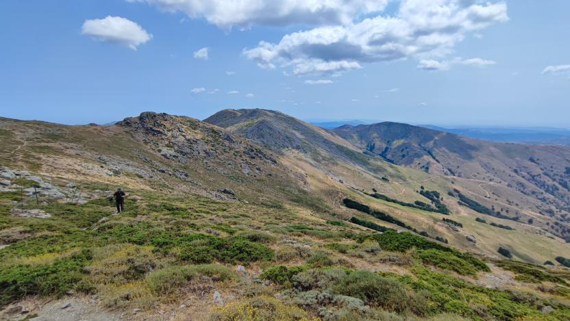
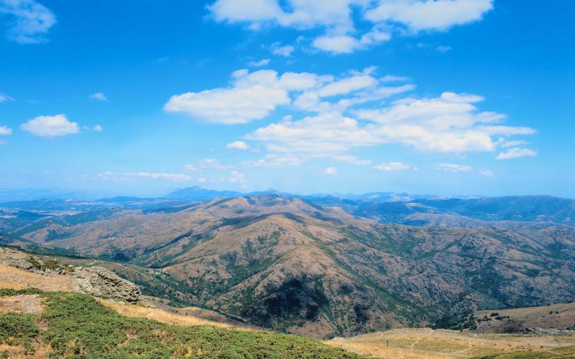
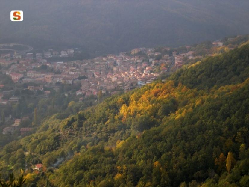
Atzara, although set in a mountainous context, has a hilly territory with gentle slopes and suggestive plateaus. It is an environment also suited for wine-growing, which characterises this centre in its rural landscape, economy and also in its urban environment, with some themed murals and numerous house courtyards, which during the grape harvest host activities for family production. The path includes some asphalt hamlets, but traffic is scarce, limited to landowners, and generally re-spectful of walkers or cyclists. At the same time, there are some areas with exclusively unpaved roads and even narrower cart tracks, which are the merit of this hike. It is also possible to hike in the rain and in case of snow, which, although not as frequent as in the villages at higher altitudes, is a possibil-ity every winter.

Informazioni utili

The LEADER Territory of the Local Action Group (GAL) Rural District Barbagia Mandrolisai Gennargentu (BMG)

Consisting of the Union of Municipalities of Barbagia and the Mountain Community of Gennargentu Mandrolisai. The GAL BMG, therefore, includes 19 municipalities, with a total area of 854.30 sq km and a resident population of approximately 22,000 inhabitants: Aritzo, Atzara, Austis, Belvì, Desulo, Gadoni, Gavoi, Lodine, Meana Sardo, Ollolai, Oniferi, Olzai, Ortueri, Ovodda, Sarule, Sorgono, Teti, Tiana, Tonara.

The GAL Rural District BMG, established in 2009, is a participation foundation composed of 22 public members and over 200 private members, representing the main institutional, economic, and social components of the territory. The foundation aims to improve the quality of life and well-being of communities in the historical regions of Barbagia, Mandrolisai, and Gennargentu by enhancing local resources. The main thematic and intervention areas identified by the GAL BMG for the definition of its Local Development Strategy 2014-2022 are the development and innovation of local production chains and systems, social inclusion, and sustainable tourism.

THE OAST PROJECT: OUTDOOR ACTIVITIES FOR SUSTAINABLE TOURISM

The project, coordinated by the GAL BMG in partnership with the GAL Sisteron-Buëch (France) and the GAL Kilkenny (Ireland), aims to promote sustainable and active tourism in rural areas of Europe. The specific objective of the project was to enhance and develop the tourist attractiveness of the inland waters of Barbagia, through outdoor sports and water activities, in line with the thematic area "sustainable tourism" chosen in the GAL BMG's PDA. The three territories involved boast a rich and varied natural, landscape, and cultural heritage with strong identity traits and enormous potential for the development of active tourism. However, some problems common to all partners have been highlighted, such as: insufficient enhancement and tourist promotion of inland areas, isolation, the absence of an international network useful for the exchange of good practices, and insufficient diversification, delocalization, deseasonalization, and internationalization of tourist flows. The OAST Project was created to respond to these critical issues, as active tourism and sustainable tourism represent the basis for the revival of territories characterized by enormous problems of depopulation, lack of services, unemployment, and school dropout. The idea, therefore, is to promote forms of sustainable, active, responsible, and experiential tourism, as well as to offer diversified and deseasonalized solutions suitable for a constantly growing number of active tourists. The specific action involved the georeferencing and description, in Italian and English, of 19 GAL BMG itineraries related to the theme of water. The itinerary tracks are available and downloadable, in Gpx format, on these pages and also on the GAL BMG's Wikiloc account.

Lenght 11.100 m

Atzara - Su Pranu.gpx

Total elevation gain 294 metri

Geographical area Gennargentu

Contiene carte
Spento

Su Pranu - Atzara

AVVERTENZE

QUESTO ITINERARIO è riportato "tal quale" a titolo informativo e di mera recensione/ricognizione degli itinerari presenti nel territorio  -  come fornito e recensito dal progetto OAST condotto dal GAL BMG nel 2024. 
NOTA: Molti itinerari sono composti da percorsi stretti e richiedono una cura periodica della vegetazione, al momento non assicurata da una gestione  di tipo  ufficiale, non essendo il tracciato inserito nella"rete escursionistica della Sardegna".  
Nota 2: Prima di recarvi sul posto si consiglia di raccogliere informazioni sullo stato di fruibilità, presso il comune competente, per avere certezza dell'effettiva percorribilità dell'itinerario scelto.

IL PERCORSO IN PILLOLE (elementi informativi essenziali)

Il punto di partenza si trova lungo la strada principale di Atzara, via Vittorio Emanuele, che è anche la Strada Statale 128. Più precisamente si parte dal bivio con la via Oristano, che è anche la Strada Provinciale 61. Se non ci fosse posto in  queste due strade potete parcheggiare anche nella via Ballero, che è già traccia.

Descrizione

L’itinerario consente di conoscere una parte inaspettata della subregione del Mandrolisai, dal momento che Atzara, pur  essendo inserita in un più vasto contesto montagnoso, ha un territorio collinare con lievi pendenze e suggestivi altopiani. Non a caso è un ambiente vocato anche per la viticoltura, che caratterizza il paese nel paesaggio rurale, nell’economia e anche nell’ambiente urbano, con alcuni murales a tema e numerosi cortili delle case che durante la vendemmia ospitano le attività per le produzioni familiari. 

Il cammino comprende alcune frazioni in asfalto, dal momento che le campagne sono state infrastrutturate per supportare la fiorente viticoltura, ma il traffico è scarso, limitato ai proprietari dei fondi, e generalmente rispettoso degli escursionisti a piedi o in bici. Al contempo sono rimaste alcune aree con strade  esclusivamente sterrate e ancora più strette mulattiere che costituiscono il pregio di questa escursione, per esempio la sterrata e poi la mulattiera che dall’estremità nord del percorso, in prossimità di Sorgono, si dirige a sud in mezzo ai  pascoli di Su Pranu e al bosco di Su Lìgiu, che nella pronuncia locale sta per Su Lillu. 

È possibile la percorrenza anche in caso di pioggia e in caso di neve che, pur non essendo frequente come per i paesi alle quote più alte, è una eventualità in ogni inverno. Il paese si trova a circa 550 m slm e il punto più alto dell’escursione arriva a circa 750 m slm, contornati dalle montagne di alcuni paesi vicini che arrivano a 1000 m di quota e oltre.

Informazioni utili

Il territorio LEADER del Gruppo di Azione Locale (GAL) Distretto Rurale Barbagia Mandrolisai Gennargentu (BMG) 

Costituito dall'Unione dei Comuni Barbagia e dalla Comunità Montana Gennargentu Mandrolisai. Il GAL BMG comprende, quindi, 19 comuni, per una superficie complessiva di 854,30 kmq e una popolazione residente pari a circa 22.000 abitanti: 

Aritzo, Atzara, Austis, Belvì, Desulo, Gadoni, Gavoi, Lodine, Meana Sardo, Ollolai, Oniferi, Olzai, Ortueri, Ovodda, Sarule, Sorgono, Teti, Tiana, Tonara.


Il GAL Distretto Rurale BMG, costituito nel 2009, è una Fondazione di partecipazione composta da 22 soci pubblici e oltre 200 privati, rappresentativi delle principali componenti istituzionali, economiche e sociali del territorio. La fondazione ha lo scopo di migliorare la qualità della vita e il benessere delle comunità nelle regioni storiche Barbagia, Mandrolisai e Gennargentu mediante la valorizzazione delle risorse locali.
I principali ambiti tematici e di intervento individuati dal GAL BMG per la definizione della propria Strategia di Sviluppo Locale 2014-2022 sono lo sviluppo e l’innovazione delle filiere e dei sistemi produttivi locali, l’inclusione sociale ed il turismo sostenibile.


IL PROGETTO OAST: OUTDOOR ACTIVITIES FOR SUSTAINABLE TOURISM

Il progetto, coordinato dal GAL BMG in partenariato con il GAL Sisteron-Buëch (Francese) e
il GAL Kilkenny (Irelanda), intende promuovere un turismo sostenibile e attivo nelle aree
rurali d’Europa.
L’obiettivo specifico del progetto è stato potenziare e sviluppare l’attrattività turistica delle acque
interne della Barbagia, attraverso gli sport all’aria aperta e le attività acquatiche, in coerenza con l’ambito tematico “turismo sostenibile” prescelto nel PDA del GAL BMG.
I tre territori coinvolti vantano un patrimonio naturalistico, paesaggistico e culturale ricco e variegato con forti caratteri identitari ed enormi potenzialità di sviluppo di turismo attivo
Tuttavia, sono stati evidenziati alcuni problemi comuni a tutti i partner, quali: l’insufficiente valorizzazione e promozione turistica delle aree interne, l’isolamento, l’assenza di un network internazionale utile per lo scambio di buone prassi, e l’insufficiente diversificazione, delocalizzazione, destagionalizzazione e l’internazionalizzazione dei flussi turistici. Il Progetto OAST nasce per rispondere a queste criticità, in quanto il turismo attivo ed il turismo sostenibile rappresentano la base di rilancio dei territori caratterizzati da enormi problemi di spopolamento, carenza di servizi, disoccupazione e dispersione scolastica.
L’idea, quindi è promuovere forme di turismo sostenibile, attivo, responsabile ed esperienziale, nonché
offrire soluzioni diversificate e destagionalizzate adatte ad un numero di turisti attivi in continua crescita.
L’azione specifica ha previsto la georeferenziazione e descrizione, in lingua italiana e inglese, di
19 itinerari del GAL BMG legati al tema dell’acqua. Le tracce degli itinerari sono disponibili e scaricabili, in formato Gpx, in queste pagine e anche nell’account Wikiloc del GAL BMG

Lenght 11.100 m

Atzara - Su Pranu.gpx

Total elevation gain 294 metri

Geographical area Gennargentu

Contiene carte
Spento

Sentiero Italia (Stage Z20) Caserma Forestale Montarbu - Taquisara

Overview of the itinerary

Sentiero Italia runs the length of the island’s eastern side, covering its most important mountains, in 28 stages.  Starting from the north: it flanks the Monte Limbara massif, crosses the limestones of Mont’Albo and Tuttavista, skirting the Gulf of Orosei, it crosses the Supramonte, Gennargentu and the Tacchi of Ogliastra and reaches Perdasdefogu.  Further south, it passes through Armungia and the Gerrei sub-region. Lastly, it touches on the villages of Burcei and San Gregorio, continuing on the Sette Fratelli massif to the old prisons of Castiadas.

General information on Sentiero Italia (Grand Italian Trail)

Sentiero Italia, or Grand Italian Trail, as also explained on the official website, is a walking route that crosses the whole of Italy, using mainly but not exclusively “registered trails”.   
In particular, in Sardinia, not all the stages of the Sentiero Italia of CAI (Italian Alpine Club) are made of trails already included in the registry of the Sardinia Trail Network (RES), either because they have not yet been tested and approved or simply because they cannot be registered as they do not meet the requirements.  However, as a whole, the Sentiero Italia is the single longest walking route currently crossing Sardinia from the north (S. Teresa Gallura, stage Z 1) to the south (Castiadas, end of stage Z 28), touching on the most fascinating mountain areas in central-eastern Sardinia: the plateau of Buddusò, Tepilora, the Cedrino river valley, the ancient forests of Montes, Perda Liana and the regional forest of Montarbu, Monte Genis, and lastly the regional forest of Settefratelli (among the many crossed by the various stages of this long hiking itinerary).

Information on this stage of the trail

This stage starts at the Montarbu forest ranger station, a beautiful facility that the Forestas Agency makes available for overnight stays, booking a few days in advance with the relevant offices in Lanusei. The site is well equipped and here you can refill your water supply. 

Walking along a dirt track, after about 800 m you will go through a gate and continue along a well-marked path until you have the railway on your right. Currently, the trenino verde (‘little green train’) that runs on that route is not operating due to maintenance work on the ‘su irtzioni’ bridge 800 m further ahead. 

The path continues on a dirt track parallel to the railway, through the forest and after about 2 km, it emerges onto a large clearing with a picnic area and a pinnetto (traditional shepherd’s hut) in need of restoration. Further on, turning left for about 300 m, is the beautiful ‘funtana de sa berda spring. The path continues downhill, and with a couple of bends you will reach the 'Riu sa taula’ river. You can cross the river near a beautiful natural pool with a small waterfall. Continue uphill following the course of the river, which is full of interesting sights, including a large limestone formation in the shape of a tortoise. After about 1 km, you will arrive at another picnic area, in the ‘Tuvu Nieddu locality where there is an abundant spring. Cross the river and continue on a dirt track to the bar-restaurant where there is a beautiful picnic area (not open all year round) near which there is also a stop of the trenino verde (‘little green train’), called ‘Stazione di Niala.

The Sentiero Italia continues to the left on a steep upward path with some paved sections. On the right, halfway up the slope, deviating from the trail, you will find a sculpture by famous artist Pinuccio Sciola depicting 6 limestone balls with a diameter of 80 cm. Here too you will find drinking water and a picnic area

Returning to the route, still through the forest, you will come to a plateau where a dirt track leads, after about 5 km, to a fascinating archaeological site, ‘is Tostoinus. Here you can admire a nuraghe (prehistoric stone fortress) and a tomb of the giants (megalithic communal tomb). 

Further on, crossing a stream with a picturesque wooden bridge, you will reach a picnic area with drinking water and a very well maintained pinnetto (shepherd’s hut) that might be used as a camping facility in the future. 

Leaving this area, which is very well maintained by Forestas, the ascent to the ridge begins. Here, the craggy and arid terrain makes the route particularly challenging during the summer. After about 4 km, the descent towards the end of the stage begins along a well-cleared and very scenic path that runs along the entire valley. Once in Gairo Taquisara, a picturesque small village with 300 inhabitants huddled at the bottom of a valley clothed in holm oaks and fir trees, you can stay overnight at a hotel or B&B or stop for refreshments at the bar. 

A very beautiful, not very long, stage through the woods of ‘Tonneri di Ussasai-Seui’, a shaded area with several freshwater springs.

Lenght 12.300 m

SI Z20.gpx

Total elevation gain 603 metri

Sentiero Italia (Tappa Z20) Caserma Forestale Montarbu - Taquisara

In sintesi

Il Sentiero Italia attraversa in lunghezza il settore orientale dell’isola toccandone i sistemi montuosi più rilevanti, in 28 tappe.  Partendo da nord: tocca il massiccio del Monte Limbara, attraversa i calcari del Mont'Albo e del Tuttavista sfiorando il Golfo di Orosei,  attraversa il Supramonte, il Gennargentu, i Tacchi dell’Ogliastra e giunge a Perdasdefogu.  Più a sud, transita da Armungia e dalla subregione del Gerrei. Infine tocca l’abitato di Burcei e San Gregorio, per continuare nel massiccio dei Sette Fratelli fino alle vecchie carceri di Castiadas.

Informazioni generali sull'itinerario sentiero Italia

Il Sentiero Italia, come spiegato anche nel sito ufficiale, è un itinerario (o Cammino) lungo tutta l'Italia, che utilizza prevalentemente ma non esclusivamente "sentieri accatastati".   
In particolare, in Sardegna, non tutte le tappe del Sentiero Italia del CAI coincidono con sentieri già inseriti nel catasto della Rete Escursionistica della Sardegna (RES), perché non hanno ancora superato le verifiche di percorribilità oppure semplicemente perché non possono essere accatastati non avendone i requisiti.  Tuttavia, nel suo insieme, il Sentiero Italia rappresenta l'unica, la più grande dorsale escursionistica che attraversa attualmente la nostra Isola da nord (S. Teresa Gallura, tappa Z 1) a sud (Castiadas, fine tappa Z 28) toccando le aree montane della Sardegna centro-Orientale più affascinanti: l'altopiano di Buddusò, Tepilora, la valle del Cedrino, i boschi vetusti di Montes, Perda Liana e la foresta demaniale di Montarbu, il Monte Genis, e infine la foresta demaniale di Settefratelli (tra le tante attraversate dal lungo itinerario escursionistico a tappe).

Info sul percorso di questa tappa

Partenza dalla caserma della forestale di Montarbu, bellissimo posto che l'azienda Fo.Re.S.T.A.S. mette a disposizione per pernottamento, prenotando qualche giorno prima presso la direzione competente di Lanusei. Il sito è bene attrezzato, e tra le altre cose si può fare rifornimento d'acqua

Si cammina su uno sterrato carrabile e dopo circa 800 metri si attraversa un cancello e si prosegue lungo un sentiero ben segnato fino ad avere la ferrovia alla nostra destra. Al momento il trenino verde che percorre quella tratta non è attivo per lavori di manutenzione sul ponte "su irtzioni" che si trova 800 metri più avanti. 

Il sentiero prosegue su una sterrata parallela alla ferrovia, in mezzo al bosco e dopo circa 2 km, sbuca in un largo spiazzo dove c'è un area picnic ed un pinnetto da restaurare. Più avanti, deviando a sinistra per circa 300 metri, c'è la bella sorgente "funtana de sa berda". Il sentiero prosegue in discesa, e con un paio di tornanti si arriva al fiume "Riu sa taula”, lo si attraversa nei pressi di una bella piscina naturale con una piccola cascata. Si prosegue in salita lungo il corso del fiume ricco di particolarità, tra cui una grande formazione calcarea a forma di testuggine. Dopo circa 1 km si arriva ad una altra area picnic, in località "Tuvu Nieddu" dove sgorga una ricca sorgente d'acqua. Si attraversa il fiume e si prosegue su una sterrata carrabile fino al bar ristorante dove si trova una bella area attrezzata, non aperta tutto l'anno, nei cui pressi si trova anche una fermata del trenino verde, chiamata "Stazione di Niala”.

Il Sentiero Italia prosegue sulla sinistra in una salita ripida a tratti cementata. Sulla destra, a metà salita, deviando dal sentiero, c'è un opera di un famoso artista Pinuccio Sciola raffigurante 6 palle di calcare del diametro di 80 cm, anche qui c'è acqua e un'area picnic

Rientrando sul percorso, sempre in mezzo al bosco, si arriva su un altopiano dove una sterrata carrabile ci porta, dopo circa 5 km, ad una zona archeologica di particolare interesse "is Tostoinus". Si possono ammirare un nuraghe ed una tomba dei giganti

Più avanti, attraversando un rio con un ponte in legno molto bello, si raggiunge un area picnic con acqua ed un pinnetto molto bene tenuto che in futuro si potrebbe adibire a bivacco. 

Uscendo da quest'area molto curata da  Fo.Re.S.T.A.S., inizia la salita per raggiungere la cresta. Qui il terreno montuoso ed arido rende il percorso particolarmente impegnativo durante l'estate. Dopo circa 4 km inizia la discesa verso il fine tappa lungo un sentiero ben pulito e molto panoramico, che costeggia tutta la vallata. Arrivati a Gairo Taquisara, piccolo e bellissimo borgo con 300 abitanti situato ai piedi di una vallata piena di lecci e abeti, è possibile pernottare presso hotel o B&B o rifocillarsi al bar. 

Tappa molto bella, non molto lunga, in mezzo ai boschi del "Tonneri di Ussasai-Seui", ombreggiata e ben fornita di sorgenti.

Informazioni utili

Lungo il percorso non sarà sempre presente la copertura telefonica

Lenght 12.300 m

SI Z20.gpx

Total elevation gain 603 metri

Ovodda, Mihinari. A privileged view

Access

From the village of Ovodda, take Via Gennargentu, entering the narrow alleyways of the centre and then leaving the village uphill on an asphalt road. Having passed a fork in the road that leads back to the SS128, a hardware store is located to the left and the road is immediately flanked by a beautiful hazel grove and woodland. Continue uphill on asphalt, keeping a small reservoir on the right. At the next crossroads, take a left uphill, following the signs for the Badu 'e Fonne agritourism, then continue straight on at the next crossroads, right at the Badu 'e Fonne locality, leaving the agriturismo of the same name on the right after a few metres. 

The wood 

At Badu 'e Fonne it is necessary to leave the car and continue on foot. Next to the agriturismo, the road makes a sharp climb on a cemented surface and then continues with gentle ups and downs, immersed in dense woodland, a paradise for mushroom foragers. A short descent leads to a widening where there is a characteristic crossroads with three roads, in the locality of Godditorzu. Hhere you go straight ahead, passing an isolated electricity pole. The dirt road soon becomes a cart track and begins to climb steeply in a magnificent forest, in which young holm oaks and downy oaks stand out in particular, interspersed with heather and sporadic hollies. 

Mihinari 

Take a right at the next crossroads, always keeping to what appears to be the main road and juggling the numerous forks in the road. The ascent is the only certain direction: as one gains height, one appreciates small openings in the vegetation that allow splendid shots of the Barbagia di Ollolai. A twisted oak tree is a sign that you are on the right track and a last uphill climb leads you out of the woods. The bare summit of Mihinari is preceded by the scent of thyme and, in spring, by colourful blooms, including the rare Armeria gennargentea. From the rounded peak of the relief, the panorama is superb and sweeps along the entire horizon, dominating the Gennargentu, all the Taloro and Aratu valleys, the distant Supramonte and remote western reliefs. At the foot of the mountain, the steep Rio Torrei valley with its small reservoir. Satiated with the panorama, one faces the return route via the passes already travelled.

Lenght 13.600 m

ovodda.gpx

Total elevation gain 641 metri