Start website main content

Nordic Walking

51 pathways

La camminata nordica o camminata con bastoni (in inglese nordic walking o pole walking) è attività fisica e sportiva che ben si coniuga con percorsi in bosco, in pianura o in vallate, lungo scogliere o spiagge.  La Rete dei sentieri della Sardegna offre tantissime occasioni per cimentarsi nella camminata nordica... 

Nordic-walking.png

Results

Sentiero Italia (Stage Z28) Valico Sette Fratelli - Castiadas

Overview of the itinerary

Sentiero Italia runs the length of the island’s eastern side, covering its most important mountains, in 28 stages.  Starting from the north: it flanks the Monte Limbara massif, crosses the limestones of Mont’Albo and Tuttavista, skirting the Gulf of Orosei, it crosses the Supramonte, Gennargentu and the Tacchi of Ogliastra and reaches Perdasdefogu.  Further south, it passes through Armungia and the Gerrei sub-region. Lastly, it touches on the villages of Burcei and San Gregorio, continuing on the Sette Fratelli massif to the old prisons of Castiadas.

General information on Sentiero Italia (Grand Italian Trail)

Sentiero Italia, or Grand Italian Trail, as also explained on the official website, is a walking route that crosses the whole of Italy, using mainly but not exclusively “registered trails”.   
In particular, in Sardinia, not all the stages of the Sentiero Italia of CAI (Italian Alpine Club) are made of trails already included in the registry of the Sardinia Trail Network (RES), either because they have not yet been tested and approved or simply because they cannot be registered as they do not meet the requirements.  However, as a whole, the Sentiero Italia is the single longest walking route currently crossing Sardinia from the north (S. Teresa Gallura, stage Z 1) to the south (Castiadas, end of stage Z 28), touching on the most fascinating mountain areas in central-eastern Sardinia: the plateau of Buddusò, Tepilora, the Cedrino river valley, the ancient forests of Montes, Perda Liana and the regional forest of Montarbu, Monte Genis, and lastly the regional forest of Settefratelli (among the many crossed by the various stages of this long hiking itinerary).

Information on this stage of the trail

Baccu Malu is one of the peaks of the Sette Fratelli (Seven Brothers) massif, an imposing granite range in the south-eastern tip of Sardinia. The last stage in Sardinia of the ‘Sentiero Italia’ (Grand Italian Trail) developed by CAI (Italian Alpine Club) is fairly easy, also because it is mainly downhill through the Monte Arbu forest and then uphill to Bruncu su Adulu, from where you will enjoy a splendid view of the end point. 

The route ends near the old farming penal colony of Castiadas, on the coastal plain, established in the 19th century and closed in the 1950s. Today the old prison buildings can be visited with an interesting museum itinerary.

Itinerary roadbook

Lenght 14.900 m

072023_z28CAI.gpx

Total elevation gain 445 metri

Geographical area Sarrabus-Sette Fratelli

Sentiero Italia (Tappa Z28) Valico Sette Fratelli - Castiadas

In sintesi

Il Sentiero Italia attraversa in lunghezza il settore orientale dell’isola toccandone i sistemi montuosi più rilevanti, in 28 tappe.  Partendo da nord: tocca il massiccio del Monte Limbara, attraversa i calcari del Mont'Albo e del Tuttavista sfiorando il Golfo di Orosei,  attraversa il Supramonte, il Gennargentu, i Tacchi dell’Ogliastra e giunge a Perdasdefogu.  Più a sud, transita da Armungia e dalla subregione del Gerrei. Infine tocca l’abitato di Burcei e San Gregorio, per continuare nel massiccio dei Sette Fratelli fino alle vecchie carceri di Castiadas.

Informazioni generali sull'itinerario sentiero Italia

Il Sentiero Italia, come spiegato anche nel sito ufficiale, è un itinerario (o Cammino) lungo tutta l'Italia, che utilizza prevalentemente ma non esclusivamente "sentieri accatastati".   
In particolare, in Sardegna, non tutte le tappe del Sentiero Italia del CAI coincidono con sentieri già inseriti nel catasto della Rete Escursionistica della Sardegna (RES), perché non hanno ancora superato le verifiche di percorribilità oppure semplicemente perché non possono essere accatastati non avendone i requisiti.  Tuttavia, nel suo insieme, il Sentiero Italia rappresenta l'unica, la più grande dorsale escursionistica che attraversa attualmente la nostra Isola da nord (S. Teresa Gallura, tappa Z 1) a sud (Castiadas, fine tappa Z 28) toccando le aree montane della Sardegna centro-Orientale più affascinanti: l'altopiano di Buddusò, Tepilora, la valle del Cedrino, i boschi vetusti di Montes, Perda Liana e la foresta demaniale di Montarbu, il Monte Genis, e infine la foresta demaniale di Settefratelli (tra le tante attraversate dal lungo itinerario escursionistico a tappe).

Info sul percorso di questa tappa

Baccu Malu è una delle cime del massiccio dei Sette Fratelli, le punte che caratterizzano il versante granitico che svetta nella punta sud orientale della Sardegna. L’ultima tappa sull’isola del cammino o itinerario chiamato "Sentiero Italia Cai" non presenta difficoltà particolari anche perché si svolge su terreno prevalentemente in discesa attraverso la foresta di Monte Arbu e ancora su fino al Bruncu su Adulu da cui si gode uno  splendido panorama  sulla meta d’arrivo. 

Il percorso termina nei pressi della colonia agricola penale di Castiadas, quasi sul livello del mare, bonificata nell’800 e utilizzata fino agli anni ’50 del Novecento quando fu definitivamente chiusa. Oggi si può visitare grazie a un interessante percorso museale.

Informazioni utili

Lungo il percorso non sarà sempre presente la copertura telefonica

Itinerary roadbook

Lenght 14.900 m

072023_z28CAI.gpx

Total elevation gain 445 metri

Geographical area Sarrabus-Sette Fratelli

Contiene carte
Spento

Arredelus e Is Caddajas - Gadoni

The itinerary runs along the course of the Flumendosa river, the largest in Sardinia in terms of water flow, allowing you to descend to the banks with a few short detours from the main axis. The most characteristic points are Arredelus and Is Caddajas. The former is a stretch where the water collects in a lake, half of which is enclosed by high cliffs and the other half accessible by a beach. Is Caddajas, on the other hand, is the southern end of the excursion, consisting of two consecutive lakes surrounded by high rock walls that together have a characteristic hourglass shape. The water from the upstream lake flows into the downstream lake with a waterfall about a metre and a half high, in a narrow corri-dor that is dark due to the height of the rock walls that do not allow full illumination from the sky.

Informazioni utili

The LEADER Territory of the Local Action Group (GAL) Rural District Barbagia Mandrolisai Gennargentu (BMG)

Consisting of the Union of Municipalities of Barbagia and the Mountain Community of Gennargentu Mandrolisai. The GAL BMG, therefore, includes 19 municipalities, with a total area of 854.30 sq km and a resident population of approximately 22,000 inhabitants: Aritzo, Atzara, Austis, Belvì, Desulo, Gadoni, Gavoi, Lodine, Meana Sardo, Ollolai, Oniferi, Olzai, Ortueri, Ovodda, Sarule, Sorgono, Teti, Tiana, Tonara.

The GAL Rural District BMG, established in 2009, is a participation foundation composed of 22 public members and over 200 private members, representing the main institutional, economic, and social components of the territory. The foundation aims to improve the quality of life and well-being of communities in the historical regions of Barbagia, Mandrolisai, and Gennargentu by enhancing local resources. The main thematic and intervention areas identified by the GAL BMG for the definition of its Local Development Strategy 2014-2022 are the development and innovation of local production chains and systems, social inclusion, and sustainable tourism.

THE OAST PROJECT: OUTDOOR ACTIVITIES FOR SUSTAINABLE TOURISM

The project, coordinated by the GAL BMG in partnership with the GAL Sisteron-Buëch (France) and the GAL Kilkenny (Ireland), aims to promote sustainable and active tourism in rural areas of Europe. The specific objective of the project was to enhance and develop the tourist attractiveness of the inland waters of Barbagia, through outdoor sports and water activities, in line with the thematic area "sustainable tourism" chosen in the GAL BMG's PDA. The three territories involved boast a rich and varied natural, landscape, and cultural heritage with strong identity traits and enormous potential for the development of active tourism. However, some problems common to all partners have been highlighted, such as: insufficient enhancement and tourist promotion of inland areas, isolation, the absence of an international network useful for the exchange of good practices, and insufficient diversification, delocalization, deseasonalization, and internationalization of tourist flows. The OAST Project was created to respond to these critical issues, as active tourism and sustainable tourism represent the basis for the revival of territories characterized by enormous problems of depopulation, lack of services, unemployment, and school dropout. The idea, therefore, is to promote forms of sustainable, active, responsible, and experiential tourism, as well as to offer diversified and deseasonalized solutions suitable for a constantly growing number of active tourists. The specific action involved the georeferencing and description, in Italian and English, of 19 GAL BMG itineraries related to the theme of water. The itinerary tracks are available and downloadable, in Gpx format, on these pages and also on the GAL BMG's Wikiloc account.

Lenght 6.900 m

Gadoni - Arredelus e Is Caddajas.gpx

Total elevation gain 287 metri

Geographical area Barbagia

Contiene carte
Spento

Arredelus e Is Caddajas - Gadoni

AVVERTENZE

QUESTO ITINERARIO è riportato "tal quale" a titolo informativo e di mera recensione/ricognizione degli itinerari presenti nel territorio  -  come fornito e recensito dal progetto OAST condotto dal GAL BMG nel 2024. 
NOTA: Molti itinerari sono composti da percorsi stretti e richiedono una cura periodica della vegetazione, al momento non assicurata da una gestione  di tipo  ufficiale, non essendo il tracciato inserito nella"rete escursionistica della Sardegna".  
Nota 2: Prima di recarvi sul posto si consiglia di raccogliere informazioni sullo stato di fruibilità, presso il comune competente, per avere certezza dell'effettiva percorribilità dell'itinerario scelto.

IL PERCORSO IN PILLOLE (elementi informativi essenziali)

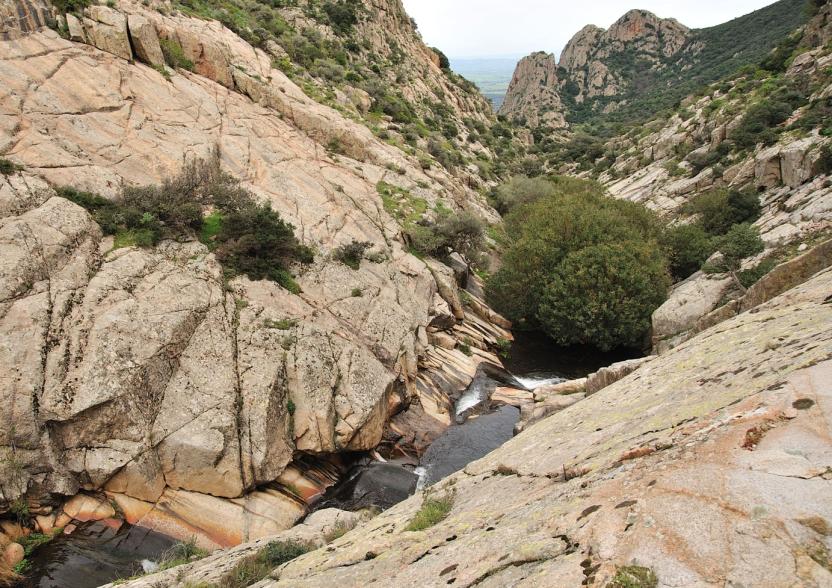
L’itinerario è di grande interesse naturalistico e storico: si sviluppa lungo il corso del fiume Flumendosa, permettendo di scendere sulle rive con alcune brevi deviazioni dall’asse principale. I punti più caratteristici sono Arredelus e Is Caddajas, che non a caso danno il nome all’itinerario, e un punto panoramico, con possibile discesa al fiume, in località Pabani.

Arredelus è un tratto in cui l’acqua si raccoglie in un lago per metà chiuso da alte pareti rocciose e per l’altra metà  accessibile con una spiaggia sassosa sulla riva destra e con un’altra spiaggia sabbiosa sulla riva sinistra. La zona specifica deve il suo nome alle filliree angustifolie d’alto fusto (phillyrea angustifolia) presenti sulle rive. Is Caddajas è l’estremità sud dell’escursione, costituita da due laghetti consecutivi circondati da alte pareti di roccia. Insieme hanno una caratteristica forma a clessidra, dove l’acqua del lago di monte si getta nel lago di valle con una cascata alta circa un metro e mezzo in un corridoio angusto perché stretto e buio, per l’altezza delle pareti di roccia che non consente una piena illuminazione dal cielo. Anche in questo caso il nome specifico è in relazione alla natura, perché la forma dei due laghi, e di alcuni altri più piccoli sopra i banchi di roccia, ricorda i paioli dalle alte pareti (caddajas) in cui si riscalda il latte per la cagliata. La località Pabani è rilevante non soltanto per il punto panoramico ma per un ampio spiazzo pianeggiante lungo il sentiero e per un bel laghetto sul fiume, circondato da alte pareti di roccia, seppure inferiori a quelle di Is  addajas.

La percorrenza in mountain bike è agevole nella parte iniziale dell’itinerario, vale a dire su sterrato per i primi 2 km, cui segue un tratto di mulattiera di 300 m fino al punto di inizio del sentiero (waypoint INIZIO SENTIERO), dove si può  archeggiare la bici e continuare a piedi. Da qui il percorso continua con 700 m di sentiero fino all’estremità sud, con alcuni tratti esposti per i quali si trova ogni tanto un passamano. La deviazione per Arredelus (250 m di lunghezza) può essere percorsa in bici, dato che si sviluppa su sterrata, mentre la deviazione per il punto panoramico di Pabani (appena 200 m di lunghezza) è su una mulattiera più ripida e sconnessa, comunque percorribile in mountain bike.

Su Ponti ‘e Ferru

L’interesse storico dell’itinerario deriva dal fatto che nel tratto iniziale si attraversa il Flumendosa su un antico ponte di ferro (waypoint PONTI ‘E FERRU), realizzato dalle officine Eiffel in moduli componibili. Una volta scaricati al porto di Cagliari, furono trasportati col treno delle allora Ferrovie Complementari Sarde fino alla stazione più vicina – comunque lontana – per poi essere portati sulle rive del fiume con i carri a buoi. Per il regime impetuoso del Flumendosa e per i ripidi versanti della gola in cui scorre, prima di allora i territori di Gadoni e Seulo - rispettivamente a nord e a sud, sulla riva destra e sinista - seppur vicini, erano isolati per lunghi periodi senza che tra le due comunità potessero esserci relazioni frequenti. La costruzione del ponte implicò la costruzione di una sterrata tra i due paesi secondo criteri moderni, al posto delle mulattiere sconnesse e pietrose che conducevano ai guadi. La allora nuova strada si caratterizzava per le pendenze diluite, per i muri di contenimento e i muretti di protezione, che si possono ancora ammirare nella prima parte del percorso, dal punto di partenza fino all’inizio della mulattiera (waypoint INIZIO MULATTIERA). Questa importante risorsa viaria è stata sostituita soltanto all’inizio degli anni Novanta del Novecento dalla costruzione di un viadotto - alto 120 m e lungo 500 m, il più alto della Sardegna - per il quale l’intero collegamento tra i due paesi è stato asfaltato, fortunatamente lasciando nella parte bassa della gola, al di sotto del viadotto, l’antica sterrata col suo caratteristico ponte.

Informazioni utili

Il territorio LEADER del Gruppo di Azione Locale (GAL) Distretto Rurale Barbagia Mandrolisai Gennargentu (BMG) 

Costituito dall'Unione dei Comuni Barbagia e dalla Comunità Montana Gennargentu Mandrolisai. Il GAL BMG comprende, quindi, 19 comuni, per una superficie complessiva di 854,30 kmq e una popolazione residente pari a circa 22.000 abitanti: 

Aritzo, Atzara, Austis, Belvì, Desulo, Gadoni, Gavoi, Lodine, Meana Sardo, Ollolai, Oniferi, Olzai, Ortueri, Ovodda, Sarule, Sorgono, Teti, Tiana, Tonara.


Il GAL Distretto Rurale BMG, costituito nel 2009, è una Fondazione di partecipazione composta da 22 soci pubblici e oltre 200 privati, rappresentativi delle principali componenti istituzionali, economiche e sociali del territorio. La fondazione ha lo scopo di migliorare la qualità della vita e il benessere delle comunità nelle regioni storiche Barbagia, Mandrolisai e Gennargentu mediante la valorizzazione delle risorse locali.
I principali ambiti tematici e di intervento individuati dal GAL BMG per la definizione della propria Strategia di Sviluppo Locale 2014-2022 sono lo sviluppo e l’innovazione delle filiere e dei sistemi produttivi locali, l’inclusione sociale ed il turismo sostenibile.


IL PROGETTO OAST: OUTDOOR ACTIVITIES FOR SUSTAINABLE TOURISM

Il progetto, coordinato dal GAL BMG in partenariato con il GAL Sisteron-Buëch (Francese) e
il GAL Kilkenny (Irelanda), intende promuovere un turismo sostenibile e attivo nelle aree
rurali d’Europa.
L’obiettivo specifico del progetto è stato potenziare e sviluppare l’attrattività turistica delle acque
interne della Barbagia, attraverso gli sport all’aria aperta e le attività acquatiche, in coerenza con l’ambito tematico “turismo sostenibile” prescelto nel PDA del GAL BMG.
I tre territori coinvolti vantano un patrimonio naturalistico, paesaggistico e culturale ricco e variegato con forti caratteri identitari ed enormi potenzialità di sviluppo di turismo attivo
Tuttavia, sono stati evidenziati alcuni problemi comuni a tutti i partner, quali: l’insufficiente valorizzazione e promozione turistica delle aree interne, l’isolamento, l’assenza di un network internazionale utile per lo scambio di buone prassi, e l’insufficiente diversificazione, delocalizzazione, destagionalizzazione e l’internazionalizzazione dei flussi turistici. Il Progetto OAST nasce per rispondere a queste criticità, in quanto il turismo attivo ed il turismo sostenibile rappresentano la base di rilancio dei territori caratterizzati da enormi problemi di spopolamento, carenza di servizi, disoccupazione e dispersione scolastica.
L’idea, quindi è promuovere forme di turismo sostenibile, attivo, responsabile ed esperienziale, nonché
offrire soluzioni diversificate e destagionalizzate adatte ad un numero di turisti attivi in continua crescita.
L’azione specifica ha previsto la georeferenziazione e descrizione, in lingua italiana e inglese, di
19 itinerari del GAL BMG legati al tema dell’acqua. Le tracce degli itinerari sono disponibili e scaricabili, in formato Gpx, in queste pagine e anche nell’account Wikiloc del GAL BMG

Lenght 6.900 m

Gadoni - Arredelus e Is Caddajas.gpx

Total elevation gain 287 metri

Geographical area Barbagia

Contiene carte
Spento

Badu Orane - Sarule

The itinerary includes, in the first half of the route, two sections of asphalt, related to Provincial Road 22, but the traffic flow is low and the scenic value is high, because in this section you can admire the village on one side and Mount Gonare with its characteristic sanctuary at the summit on the other. What’s characteristic, a little more than a kilometre from the start, is a narrow historical road, parallel to the asphalt road, about 600 m long, bordered on both sides by dry stone walls and majestic centu-ries-old oaks. In the second part of the itinerary, we follow a dirt road, mostly downhill, quite smooth, of great natural and scenic interest. It allows us to admire the village from an elevated position, through natural frames formed by the gaps between the crowns of the oaks.

Informazioni utili

The LEADER Territory of the Local Action Group (GAL) Rural District Barbagia Mandrolisai Gennargentu (BMG)

Consisting of the Union of Municipalities of Barbagia and the Mountain Community of Gennargentu Mandrolisai. The GAL BMG, therefore, includes 19 municipalities, with a total area of 854.30 sq km and a resident population of approximately 22,000 inhabitants: Aritzo, Atzara, Austis, Belvì, Desulo, Gadoni, Gavoi, Lodine, Meana Sardo, Ollolai, Oniferi, Olzai, Ortueri, Ovodda, Sarule, Sorgono, Teti, Tiana, Tonara.

The GAL Rural District BMG, established in 2009, is a participation foundation composed of 22 public members and over 200 private members, representing the main institutional, economic, and social components of the territory. The foundation aims to improve the quality of life and well-being of communities in the historical regions of Barbagia, Mandrolisai, and Gennargentu by enhancing local resources. The main thematic and intervention areas identified by the GAL BMG for the definition of its Local Development Strategy 2014-2022 are the development and innovation of local production chains and systems, social inclusion, and sustainable tourism.

THE OAST PROJECT: OUTDOOR ACTIVITIES FOR SUSTAINABLE TOURISM

The project, coordinated by the GAL BMG in partnership with the GAL Sisteron-Buëch (France) and the GAL Kilkenny (Ireland), aims to promote sustainable and active tourism in rural areas of Europe. The specific objective of the project was to enhance and develop the tourist attractiveness of the inland waters of Barbagia, through outdoor sports and water activities, in line with the thematic area "sustainable tourism" chosen in the GAL BMG's PDA. The three territories involved boast a rich and varied natural, landscape, and cultural heritage with strong identity traits and enormous potential for the development of active tourism. However, some problems common to all partners have been highlighted, such as: insufficient enhancement and tourist promotion of inland areas, isolation, the absence of an international network useful for the exchange of good practices, and insufficient diversification, delocalization, deseasonalization, and internationalization of tourist flows. The OAST Project was created to respond to these critical issues, as active tourism and sustainable tourism represent the basis for the revival of territories characterized by enormous problems of depopulation, lack of services, unemployment, and school dropout. The idea, therefore, is to promote forms of sustainable, active, responsible, and experiential tourism, as well as to offer diversified and deseasonalized solutions suitable for a constantly growing number of active tourists. The specific action involved the georeferencing and description, in Italian and English, of 19 GAL BMG itineraries related to the theme of water. The itinerary tracks are available and downloadable, in Gpx format, on these pages and also on the GAL BMG's Wikiloc account.

Lenght 8.900 m

Sarule - Badu Orane.gpx

Total elevation gain 281 metri

Geographical area Barbagia

Contiene carte
Spento

Badu Orane - Sarule

AVVERTENZE

QUESTO ITINERARIO è riportato "tal quale" a titolo informativo e di mera recensione/ricognizione degli itinerari presenti nel territorio  -  come fornito e recensito dal progetto OAST condotto dal GAL BMG nel 2024. 
NOTA: Molti itinerari sono composti da percorsi stretti e richiedono una cura periodica della vegetazione, al momento non assicurata da una gestione  di tipo  ufficiale, non essendo il tracciato inserito nella"rete escursionistica della Sardegna".  
Nota 2: Prima di recarvi sul posto si consiglia di raccogliere informazioni sullo stato di fruibilità, presso il comune competente, per avere certezza dell'effettiva percorribilità dell'itinerario scelto.

IL PERCORSO IN PILLOLE (elementi informativi essenziali)

L’itinerario si sviluppa a sud di Sarule, quindi in direzione di Ollolai, a dispetto del nome che invece farebbe pensare al paese di Orani, che si trova a nord di Sarule. Nella prima metà del percorso comprende due sezioni di asfalto, relative alla Strada Provinciale 22, ma il flusso di traffico è scarso e il valore paesaggistico è alto, perché in questo tratto si può ammirare da un lato il paese e dall’altro il monte Gonare col suo caratteristico santuario in vetta. Al km 1,2, poco dopo aver trascurato sulla sinistra il bivio per la chiesa campestre di San Bernardino, si trova un bivio a destra che immette in uno stretta sterrata parallela all’asfalto. Conduce a una strada storica, anch’essa parallela all’asfalto, lunga circa 600 m, cinta su entrambi i lati da muretti a secco e da maestose roverelle secolari. Dopo essere tornati sull’asfalto, al km 5,4 del percorso inizia una nuova parte sterrata, prevalentemente in discesa, lungo la quale si trova il torrente che dà il nome all’itinerario. È una sezione mediamente scorrevole, di grande interesse naturalistico e paesaggistico, che consente di ammirare il paese da una posizione sopraelevata attraverso cornici naturali formate dai varchi tra le chiome delle  roverelle.

Informazioni utili

Il territorio LEADER del Gruppo di Azione Locale (GAL) Distretto Rurale Barbagia Mandrolisai Gennargentu (BMG) 

Costituito dall'Unione dei Comuni Barbagia e dalla Comunità Montana Gennargentu Mandrolisai. Il GAL BMG comprende, quindi, 19 comuni, per una superficie complessiva di 854,30 kmq e una popolazione residente pari a circa 22.000 abitanti: 

Aritzo, Atzara, Austis, Belvì, Desulo, Gadoni, Gavoi, Lodine, Meana Sardo, Ollolai, Oniferi, Olzai, Ortueri, Ovodda, Sarule, Sorgono, Teti, Tiana, Tonara.


Il GAL Distretto Rurale BMG, costituito nel 2009, è una Fondazione di partecipazione composta da 22 soci pubblici e oltre 200 privati, rappresentativi delle principali componenti istituzionali, economiche e sociali del territorio. La fondazione ha lo scopo di migliorare la qualità della vita e il benessere delle comunità nelle regioni storiche Barbagia, Mandrolisai e Gennargentu mediante la valorizzazione delle risorse locali.
I principali ambiti tematici e di intervento individuati dal GAL BMG per la definizione della propria Strategia di Sviluppo Locale 2014-2022 sono lo sviluppo e l’innovazione delle filiere e dei sistemi produttivi locali, l’inclusione sociale ed il turismo sostenibile.


IL PROGETTO OAST: OUTDOOR ACTIVITIES FOR SUSTAINABLE TOURISM

Il progetto, coordinato dal GAL BMG in partenariato con il GAL Sisteron-Buëch (Francese) e
il GAL Kilkenny (Irelanda), intende promuovere un turismo sostenibile e attivo nelle aree
rurali d’Europa.
L’obiettivo specifico del progetto è stato potenziare e sviluppare l’attrattività turistica delle acque
interne della Barbagia, attraverso gli sport all’aria aperta e le attività acquatiche, in coerenza con l’ambito tematico “turismo sostenibile” prescelto nel PDA del GAL BMG.
I tre territori coinvolti vantano un patrimonio naturalistico, paesaggistico e culturale ricco e variegato con forti caratteri identitari ed enormi potenzialità di sviluppo di turismo attivo
Tuttavia, sono stati evidenziati alcuni problemi comuni a tutti i partner, quali: l’insufficiente valorizzazione e promozione turistica delle aree interne, l’isolamento, l’assenza di un network internazionale utile per lo scambio di buone prassi, e l’insufficiente diversificazione, delocalizzazione, destagionalizzazione e l’internazionalizzazione dei flussi turistici. Il Progetto OAST nasce per rispondere a queste criticità, in quanto il turismo attivo ed il turismo sostenibile rappresentano la base di rilancio dei territori caratterizzati da enormi problemi di spopolamento, carenza di servizi, disoccupazione e dispersione scolastica.
L’idea, quindi è promuovere forme di turismo sostenibile, attivo, responsabile ed esperienziale, nonché
offrire soluzioni diversificate e destagionalizzate adatte ad un numero di turisti attivi in continua crescita.
L’azione specifica ha previsto la georeferenziazione e descrizione, in lingua italiana e inglese, di
19 itinerari del GAL BMG legati al tema dell’acqua. Le tracce degli itinerari sono disponibili e scaricabili, in formato Gpx, in queste pagine e anche nell’account Wikiloc del GAL BMG

Lenght 8.900 m

Sarule - Badu Orane.gpx

Total elevation gain 281 metri

Geographical area Barbagia

Contiene carte
Spento

Sasisòrgiu - Ollolai

The itinerary starts from the village of Ollolai, at an altitude of about 950 m, one of the highest in Sar-dinia, and arrives at a mountain called San Basilio or Punta Manna, based respectively on the name of the country church or the name of the most imposing, though not the highest, of those that make up the summit of the mountain. The geology, with its huge granite boulders, is an attraction in itself, but the trail is also of great value for the forest, so dense that in some places no sunlight reaches. Be-tween the trees are numerous cavities formed by the overlapping of the boulders, which leave gaps as if to form small caves. To return to the village, we follow a historic road through the undergrowth, for a stretch encircled by drystone walls on both sides, covered by extensive mossy blankets.

Informazioni utili

The LEADER Territory of the Local Action Group (GAL) Rural District Barbagia Mandrolisai Gennargentu (BMG)

Consisting of the Union of Municipalities of Barbagia and the Mountain Community of Gennargentu Mandrolisai. The GAL BMG, therefore, includes 19 municipalities, with a total area of 854.30 sq km and a resident population of approximately 22,000 inhabitants: Aritzo, Atzara, Austis, Belvì, Desulo, Gadoni, Gavoi, Lodine, Meana Sardo, Ollolai, Oniferi, Olzai, Ortueri, Ovodda, Sarule, Sorgono, Teti, Tiana, Tonara.

The GAL Rural District BMG, established in 2009, is a participation foundation composed of 22 public members and over 200 private members, representing the main institutional, economic, and social components of the territory. The foundation aims to improve the quality of life and well-being of communities in the historical regions of Barbagia, Mandrolisai, and Gennargentu by enhancing local resources. The main thematic and intervention areas identified by the GAL BMG for the definition of its Local Development Strategy 2014-2022 are the development and innovation of local production chains and systems, social inclusion, and sustainable tourism.

THE OAST PROJECT: OUTDOOR ACTIVITIES FOR SUSTAINABLE TOURISM

The project, coordinated by the GAL BMG in partnership with the GAL Sisteron-Buëch (France) and the GAL Kilkenny (Ireland), aims to promote sustainable and active tourism in rural areas of Europe. The specific objective of the project was to enhance and develop the tourist attractiveness of the inland waters of Barbagia, through outdoor sports and water activities, in line with the thematic area "sustainable tourism" chosen in the GAL BMG's PDA. The three territories involved boast a rich and varied natural, landscape, and cultural heritage with strong identity traits and enormous potential for the development of active tourism. However, some problems common to all partners have been highlighted, such as: insufficient enhancement and tourist promotion of inland areas, isolation, the absence of an international network useful for the exchange of good practices, and insufficient diversification, delocalization, deseasonalization, and internationalization of tourist flows. The OAST Project was created to respond to these critical issues, as active tourism and sustainable tourism represent the basis for the revival of territories characterized by enormous problems of depopulation, lack of services, unemployment, and school dropout. The idea, therefore, is to promote forms of sustainable, active, responsible, and experiential tourism, as well as to offer diversified and deseasonalized solutions suitable for a constantly growing number of active tourists. The specific action involved the georeferencing and description, in Italian and English, of 19 GAL BMG itineraries related to the theme of water. The itinerary tracks are available and downloadable, in Gpx format, on these pages and also on the GAL BMG's Wikiloc account.

Lenght 5.800 m

Ollolai - Sasisòrgiu.gpx

Total elevation gain 286 metri

Geographical area Barbagia

Contiene carte
Spento