Nordic Walking
La camminata nordica o camminata con bastoni (in inglese nordic walking o pole walking) è attività fisica e sportiva che ben si coniuga con percorsi in bosco, in pianura o in vallate, lungo scogliere o spiagge. La Rete dei sentieri della Sardegna offre tantissime occasioni per cimentarsi nella camminata nordica...

Results
Pathways Da Leustra a Santa Maria (T-782)
Pathways Funtana Cungiada (T-781)
Pathways Funtana Cungiada (T-781)
Su Samucu - Belvì
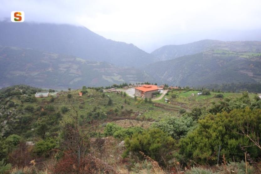
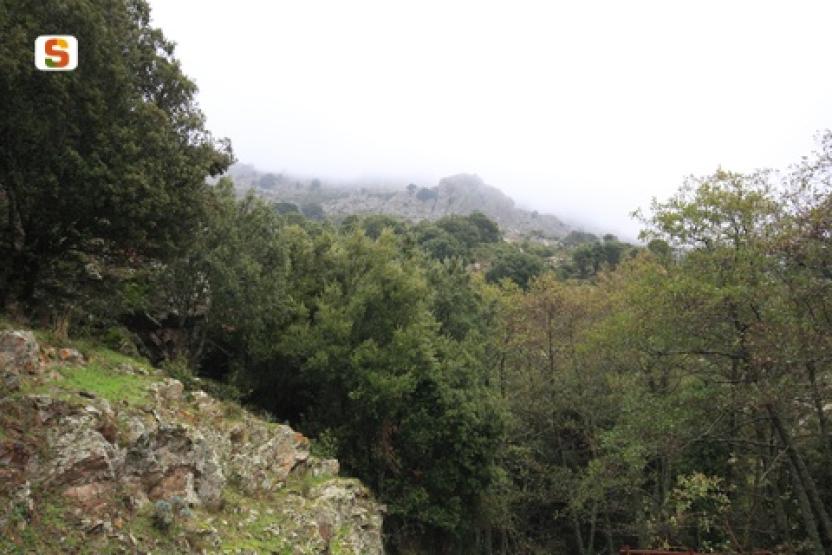
The objective of the itinerary is the historical monument of Su Samucu, a railway viaduct of the Man-das-Sorgono railway line, which has not been in operation for years. It has a double row of arches and at 39 m in height, it is one of the tallest and most spectacular bridges built in Sardinia. Built entirely of stone from a nearby quarry, constrution began in 1888 and ended in the middle of the following year. In the central part of the route, there is a short detour of only 100 m that leads to a majestic centuries-old walnut tree. The historical attraction of Su Samucu and the naturalistic attraction of the centuries-old walnut tree are complemented in the northern segment of the trail by geological at-tractions, with imposing rock faces of shale, in one of which, just 100 m from the track, is a cavity that can be a good shelter in case of rain, spacious enough to accommodate three people
Informazioni utili
The LEADER Territory of the Local Action Group (GAL) Rural District Barbagia Mandrolisai Gennargentu (BMG)
Consisting of the Union of Municipalities of Barbagia and the Mountain Community of Gennargentu Mandrolisai. The GAL BMG, therefore, includes 19 municipalities, with a total area of 854.30 sq km and a resident population of approximately 22,000 inhabitants: Aritzo, Atzara, Austis, Belvì, Desulo, Gadoni, Gavoi, Lodine, Meana Sardo, Ollolai, Oniferi, Olzai, Ortueri, Ovodda, Sarule, Sorgono, Teti, Tiana, Tonara.
The GAL Rural District BMG, established in 2009, is a participation foundation composed of 22 public members and over 200 private members, representing the main institutional, economic, and social components of the territory. The foundation aims to improve the quality of life and well-being of communities in the historical regions of Barbagia, Mandrolisai, and Gennargentu by enhancing local resources. The main thematic and intervention areas identified by the GAL BMG for the definition of its Local Development Strategy 2014-2022 are the development and innovation of local production chains and systems, social inclusion, and sustainable tourism.
THE OAST PROJECT: OUTDOOR ACTIVITIES FOR SUSTAINABLE TOURISM
The project, coordinated by the GAL BMG in partnership with the GAL Sisteron-Buëch (France) and the GAL Kilkenny (Ireland), aims to promote sustainable and active tourism in rural areas of Europe. The specific objective of the project was to enhance and develop the tourist attractiveness of the inland waters of Barbagia, through outdoor sports and water activities, in line with the thematic area "sustainable tourism" chosen in the GAL BMG's PDA. The three territories involved boast a rich and varied natural, landscape, and cultural heritage with strong identity traits and enormous potential for the development of active tourism. However, some problems common to all partners have been highlighted, such as: insufficient enhancement and tourist promotion of inland areas, isolation, the absence of an international network useful for the exchange of good practices, and insufficient diversification, delocalization, deseasonalization, and internationalization of tourist flows. The OAST Project was created to respond to these critical issues, as active tourism and sustainable tourism represent the basis for the revival of territories characterized by enormous problems of depopulation, lack of services, unemployment, and school dropout. The idea, therefore, is to promote forms of sustainable, active, responsible, and experiential tourism, as well as to offer diversified and deseasonalized solutions suitable for a constantly growing number of active tourists. The specific action involved the georeferencing and description, in Italian and English, of 19 GAL BMG itineraries related to the theme of water. The itinerary tracks are available and downloadable, in Gpx format, on these pages and also on the GAL BMG's Wikiloc account.
Tipologia itinerario
- Log in to post comments
Photogallery
Contiene carte
Spento
Su Samucu - Belvì
AVVERTENZE
QUESTO ITINERARIO è riportato "tal quale" a titolo informativo e di mera recensione/ricognizione degli itinerari presenti nel territorio - come fornito e recensito dal progetto OAST condotto dal GAL BMG nel 2024.
NOTA: Molti itinerari sono composti da percorsi stretti e richiedono una cura periodica della vegetazione, al momento non assicurata da una gestione di tipo ufficiale, non essendo il tracciato inserito nella"rete escursionistica della Sardegna".
Nota 2: Prima di recarvi sul posto si consiglia di raccogliere informazioni sullo stato di fruibilità, presso il comune competente, per avere certezza dell'effettiva percorribilità dell'itinerario scelto.
IL PERCORSO IN PILLOLE (elementi informativi essenziali)
Il punto di partenza si trova nel centro del paese di Belvì, nella piazza dell’anfiteatro. Vi si accede percorrendo la strada principale, via Roma, per poi girare in via Marconi, vicino al distributore Q8, e in via Manno.
Descrizione
L’itinerario si sviluppa verso nord, con l’obiettivo di raggiungere il monumento storico di Su Samucu, dopo il quale si ripercorre per un tratto la traccia dell’andata e successivamente una via parallela, descrivendo così un anello centrale. In questa parte centrale è possibile una breve deviazione di appena 100 m, segnalata da appositi waypoint, che conduce a un maestoso noce secolare. La traccia prosegue ricalcando la via dell’andata che, questa volta in salita, ci riporta al punto di partenza in paese. All’attrattiva storica di Su Samucu e a quella naturalistica del noce secolare si aggiungono nel segmento nord del percorso delle attrattive geologiche, con imponenti pareti rocciose di scisto, in una delle quali, ad appena 100 m dalla traccia, si apre una cavità che può essere un buon riparo in caso di pioggia, sufficientemente spaziosa per accogliere tre persone.
Per la sua caratteristica forma (lineare, anulare, lineare) l’itinerario si presta a essere modulato su varie lunghezze e conseguenti dislivelli, percorrendo soltanto il primo tratto lineare (arrivando così a 3,5 km e 90 m dsl), oppure il primo tratto lineare e l’anello (arrivando così a 11 km e 250 m dsl). In ogni caso l’elemento acquatico rimane dominante, seppure non si arrivasse al rio Uatzo, in quanto la prima parte dell’itinerario si sviluppa lungo il tratto precedente di questo stesso corso d’acqua, chiamato in questa parte rio Arase, rio S’Iscra (o Ìscara, con l’epentesi) o rio Brebì.
Il monumento storico di Su Samucu
Si tratta di un viadotto ferroviario della linea Mandas-Sorgono, delle ex Ferrovie Complementari Sarde, ora ARST, non più in funzione da anni. Ha un doppio ordine di arcate sostenute da pilastri rastremati e coi suoi 39 m di altezza è uno dei ponti più alti e spettacolari costruiti in Sardegna. Realizzato interamente in pietra proveniente da una vicina cava, fu costruito nel 1888 e terminato a metà dell'anno seguente. Il nome significa “il sambuco”, e si trova anche nella versione “semucu”. Il torrente sul fondo della gola (affluente di destra del rio Uatzo) ha un regime piuttosto irregolare e con le sue piene arriva a dissestare tutta l’area al di sotto del viadotto, che andrebbe regolarmente manutenuta, almeno nelle sue parti alte, al riparo dalle piene, per farne una suggestiva area di sosta escursionistica.
Il noce secolare
È un esemplare di noce comune (junglas regia) di circa 18 m di altezza e più di duecento anni d’età. Tra le sue caratteristiche, un ramo sul lato del torrente che arriva al suolo e prosegue la crescita verso l’alto con rami secondari. È stato iscritto nell’elenco degli Alberi monumentali d’Italia, curato dalla Direzione generale dell’economia montana e delle foreste. Dista appena 2 km dal paese e merita una visita a prescindere dalla percorrenza di questo itinerario.
Informazioni utili
Il territorio LEADER del Gruppo di Azione Locale (GAL) Distretto Rurale Barbagia Mandrolisai Gennargentu (BMG)
Costituito dall'Unione dei Comuni Barbagia e dalla Comunità Montana Gennargentu Mandrolisai. Il GAL BMG comprende, quindi, 19 comuni, per una superficie complessiva di 854,30 kmq e una popolazione residente pari a circa 22.000 abitanti:
Aritzo, Atzara, Austis, Belvì, Desulo, Gadoni, Gavoi, Lodine, Meana Sardo, Ollolai, Oniferi, Olzai, Ortueri, Ovodda, Sarule, Sorgono, Teti, Tiana, Tonara.
Il GAL Distretto Rurale BMG, costituito nel 2009, è una Fondazione di partecipazione composta da 22 soci pubblici e oltre 200 privati, rappresentativi delle principali componenti istituzionali, economiche e sociali del territorio. La fondazione ha lo scopo di migliorare la qualità della vita e il benessere delle comunità nelle regioni storiche Barbagia, Mandrolisai e Gennargentu mediante la valorizzazione delle risorse locali.
I principali ambiti tematici e di intervento individuati dal GAL BMG per la definizione della propria Strategia di Sviluppo Locale 2014-2022 sono lo sviluppo e l’innovazione delle filiere e dei sistemi produttivi locali, l’inclusione sociale ed il turismo sostenibile.
IL PROGETTO OAST: OUTDOOR ACTIVITIES FOR SUSTAINABLE TOURISM
Il progetto, coordinato dal GAL BMG in partenariato con il GAL Sisteron-Buëch (Francese) e
il GAL Kilkenny (Irelanda), intende promuovere un turismo sostenibile e attivo nelle aree
rurali d’Europa.
L’obiettivo specifico del progetto è stato potenziare e sviluppare l’attrattività turistica delle acque
interne della Barbagia, attraverso gli sport all’aria aperta e le attività acquatiche, in coerenza con l’ambito tematico “turismo sostenibile” prescelto nel PDA del GAL BMG.
I tre territori coinvolti vantano un patrimonio naturalistico, paesaggistico e culturale ricco e variegato con forti caratteri identitari ed enormi potenzialità di sviluppo di turismo attivo.
Tuttavia, sono stati evidenziati alcuni problemi comuni a tutti i partner, quali: l’insufficiente valorizzazione e promozione turistica delle aree interne, l’isolamento, l’assenza di un network internazionale utile per lo scambio di buone prassi, e l’insufficiente diversificazione, delocalizzazione, destagionalizzazione e l’internazionalizzazione dei flussi turistici. Il Progetto OAST nasce per rispondere a queste criticità, in quanto il turismo attivo ed il turismo sostenibile rappresentano la base di rilancio dei territori caratterizzati da enormi problemi di spopolamento, carenza di servizi, disoccupazione e dispersione scolastica.
L’idea, quindi è promuovere forme di turismo sostenibile, attivo, responsabile ed esperienziale, nonché
offrire soluzioni diversificate e destagionalizzate adatte ad un numero di turisti attivi in continua crescita.
L’azione specifica ha previsto la georeferenziazione e descrizione, in lingua italiana e inglese, di
19 itinerari del GAL BMG legati al tema dell’acqua. Le tracce degli itinerari sono disponibili e scaricabili, in formato Gpx, in queste pagine e anche nell’account Wikiloc del GAL BMG
Tipologia itinerario
- Log in to post comments
Photogallery
Contiene carte
Spento
Sorgono, the plateau of the Nuraghes. Between history and nature
Access
Take the SS 128, which is the main road of the inhabited centre of Sorgono. At the same level of the Cantina Sociale del Mandrolisai, on the opposite side of the road, wooden signs indicate some archaeological sites. You then follow Via Emilia, turning left at a large fork where you come to another signpost indicating Sentiero Escursionistico (Hiking Trail). Continue along the asphalt road for about 4 km until you come to a sign on the right indicating the Nuraghe Lò. You can park the car here.
Nuraghe Lò
You turn right uphill along a small dirt road, immersed in an Oak forest. After a short stretch, on the left, the beautiful nuragic tower stands out, built on a rocky outcrop formation and placed in a n elevated position. The plan of the structure is slightly elliptical and has the peculiarity of having an architraved window placed at the end of a slightly curved corridor that is in a mirror-image position to the entrance.
Santu Loisu
You descend back to the asphalt road, soon encountering a sign marking the entrance to the forestry yard, which also houses a beautiful nursery. You are now in the locality of Santu Loisu and enter a plot of land to the left of the road, where there are two buildings belonging to a mountain colony and a natual spring. On the right, a small path leads to the domus de Janas of Santu Loisu, consisting of two small chambers at ground level and immersed in a beautiful wood. You return to the tarmac road, continuing for a few hundred metres until you come to an imperceptible bend to the left. On the left of the road, immersed in the woods, is the beautiful tower of Nuraghe Bardacolo, set in a dominant position. Although extremely high, from its summit you can enjoy a wide panorama.
Nuraghe Orrubiu
The route continues on the main road, now slightly downhill. On the right-hand side of the road after a long stretch through the beautiful oak forest. Just before an electrical transformer cabin you come to the sign for Nuraghe Orrubiu, on the right. The beautiful single tower is slightly raised on a ploughed field and owes its name to the reddish mosses that have colonised its beautiful granite stones. Continuing along the main road, you will come across another sign, also on the right, that would allow you to visit a giants' tomb.
S’Incodine
On the left-hand side of the road, before turning back, you will come across a ladder type style that provides access to a vast pastureland. Behind it, near a rocky prominence stands the monument known as S'Incodine (The Anvil), due to its characteristic shape. Not far away, but difficult to find, are the Domus de Janas of Perdonigheddu and the Cherbos nuraghe. You return to the car by the road followed on the outward journey.
Tipologia itinerario
- Log in to post comments
Photogallery
Sorgono, l’altopiano dei Nuraghes. Tra storia e natura
Accesso
Si percorre la SS 128 che costituisce la via principale del centro abitato di Sorgono. All’altezza della Cantina Sociale del Mandrolisai, sul lato opposto della strada, si individuano i cartelli in legno che indicano alcuni siti archeologici. Si percorre quindi la Via Emilia, prendendo poi a sinistra ad un grosso bivio dove si incontra un altro cartello che indica “Sentiero Escursionistico”.
Si prosegue su strada asfaltata per circa 4 km, fino ad incontrare, sulla destra, il cartello che indica il nuraghe Lò.
Qui si posteggia.
Nuraghe Lò
Si prende a destra in salita per una stradina bianca, immersi nel bosco di querce. Dopo un breve tratto, sulla sinistra, spicca la bella torre nuragica, costruita su uno spuntone roccioso e posto in posizione rilevata. La pianta del monumento è leggermente ellittica ed ha la particolarità di possedere una finestra architravata, posta al termine di un corridoio leggermente curvo che si trova in posizione speculare rispetto all’entrata.
Santu Loisu
Si ridiscende alla strada asfaltata, incontrando in breve un cartello che segna l’ingresso del cantiere forestale che ospita anche un bel vivaio. Si è in località Santu Loisu e si entra in un terreno alla sinistra della strada, dove si trovano due edifici appartenenti ad una colonia montana ed una sorgente. Sulla destra, un piccolo sentierino porta alle Domus de Janas di Santu Loisu, costituite da due piccole celle all’altezza del terreno ed immerse in un bel bosco. Si ritorna alla strada asfaltata, proseguendo per poche centinaia di metri fino ad incontrare una impercettibile curva a sinistra. Sulla sinistra della strada, immersa nel bosco, si trova la bella torre di Nuraghe Bardacolo, posta in posizione dominante. Anche se svettata, dalla sua cima si gode di un ampio panorama.
Nuraghe Orrubiu
Si riprende ancora sulla strada principale che va a sterrarsi, ora leggermente in discesa. Sulla destra della strada, dopo un lungo tratto nel bel querceto. Poco prima di una cabina di trasformazione elettrica si incontra il segnale per Nuraghe Orrubiu, sulla destra. Il bel mono-torre è leggermente rilevato su un campo arato e deve il suo nome ai muschi rossicci che ne hanno colonizzato le belle pietre granitiche. Continuando sulla strada principale si incontra un’altra indicazione, sempre sulla destra, che permetterebbe di visitare una tomba dei giganti.
S’Incodine
A sinistra della strada, prima di tornare indietro, si incontra uno scalandrino che permette di accedere a un vasto pascolo. Alle sue spalle, presso un risalto roccioso, si trova il monumento noto come S’Incodine, per la sua forma caratteristica. Non lontane, ma di difficile reperimento, si trovano le Domus de Janas di Perdonigheddu ed il nuraghe Cherbos. Si ritorna all’auto per la strada seguita all’andata
Tipologia itinerario
- Log in to post comments
Photogallery
Ovodda - Antriocu Soddu
This is a short itinerary, but of great naturalistic and technical value. Good driving skills are required for the long stony descent from an altitude of 1060 m to an altitude of 700 m. The soil is granitic, washed out, resulting in many deep furrows, loose stone and gravelly and sandy surfaces. Plan the hike with caution, always bearing in mind your abilities and available time, because at high altitudes a change in the weather can become problematic if it catches you in a precarious condition. Adding to the sporting value of the itinerary is the historical interest with the Pedras Fitas menhirs in the stream valley and the domus de janas of Sos Forros. The latter are in a state of disrepair, partially buried, yet they are easily recognisable and worth a visit.
Informazioni utili
The LEADER Territory of the Local Action Group (GAL) Rural District Barbagia Mandrolisai Gennargentu (BMG)
Consisting of the Union of Municipalities of Barbagia and the Mountain Community of Gennargentu Mandrolisai. The GAL BMG, therefore, includes 19 municipalities, with a total area of 854.30 sq km and a resident population of approximately 22,000 inhabitants: Aritzo, Atzara, Austis, Belvì, Desulo, Gadoni, Gavoi, Lodine, Meana Sardo, Ollolai, Oniferi, Olzai, Ortueri, Ovodda, Sarule, Sorgono, Teti, Tiana, Tonara.
The GAL Rural District BMG, established in 2009, is a participation foundation composed of 22 public members and over 200 private members, representing the main institutional, economic, and social components of the territory. The foundation aims to improve the quality of life and well-being of communities in the historical regions of Barbagia, Mandrolisai, and Gennargentu by enhancing local resources. The main thematic and intervention areas identified by the GAL BMG for the definition of its Local Development Strategy 2014-2022 are the development and innovation of local production chains and systems, social inclusion, and sustainable tourism.
THE OAST PROJECT: OUTDOOR ACTIVITIES FOR SUSTAINABLE TOURISM
The project, coordinated by the GAL BMG in partnership with the GAL Sisteron-Buëch (France) and the GAL Kilkenny (Ireland), aims to promote sustainable and active tourism in rural areas of Europe. The specific objective of the project was to enhance and develop the tourist attractiveness of the inland waters of Barbagia, through outdoor sports and water activities, in line with the thematic area "sustainable tourism" chosen in the GAL BMG's PDA. The three territories involved boast a rich and varied natural, landscape, and cultural heritage with strong identity traits and enormous potential for the development of active tourism. However, some problems common to all partners have been highlighted, such as: insufficient enhancement and tourist promotion of inland areas, isolation, the absence of an international network useful for the exchange of good practices, and insufficient diversification, delocalization, deseasonalization, and internationalization of tourist flows. The OAST Project was created to respond to these critical issues, as active tourism and sustainable tourism represent the basis for the revival of territories characterized by enormous problems of depopulation, lack of services, unemployment, and school dropout. The idea, therefore, is to promote forms of sustainable, active, responsible, and experiential tourism, as well as to offer diversified and deseasonalized solutions suitable for a constantly growing number of active tourists. The specific action involved the georeferencing and description, in Italian and English, of 19 GAL BMG itineraries related to the theme of water. The itinerary tracks are available and downloadable, in Gpx format, on these pages and also on the GAL BMG's Wikiloc account.
Tipologia itinerario
- Log in to post comments
Photogallery
Contiene carte
Spento