Start website main content

Results

Sulcis

Il Sulcis (Maurreddìa in sardo) è un territorio che si estende nella porzione sud-occidentale dell'Isola, parte integrante della regione storico-geografica del Sulcis-Iglesiente. Prende il nome dall'antica città punica di Sulki o Sulci  (oggi Sant'Antioco).  La delimitazione del Sulcis non è ben definita in quanto si tende talvolta ad estenderla in senso lato comprendendo anche parte del territorio dell'Iglesiente oppure anche i territori di Pula, Villa San Pietro e Sarroch, la cui collocazione geografica è incerta e controversa: il Sulcis propriamente detto corrisponde al versante sud-occidentale dei Monti del Sulcis e alla piana sottostante fino alla costa sudoccidentale che si affaccia sul Canale di Sardegna, da capo Altano, o capo Giordano, fino al Golfo di Palmas e da qui continua verso il Capo Teulada. Per affinità politiche-geografiche è considerato parte del territorio sulcitano l'arcipelago del Sulcis, con le isole di San Pietro e di Sant'Antioco.  Più incerta è la collocazione di Pula, Villa San Pietro e Sarroch, che fanno parte della Provincia di Cagliari e sono situati lungo la costa del Golfo degli Angeli, ai piedi del versante sud-orientale dei monti del Sulcis, nella parte esterna del territorio sulcitano. L'entroterra montano di questi comuni ha infatti un'affinità e un'omogeneità ambientale con il Sulcis, tuttavia i centri abitati giacciono su una piana costiera geograficamente isolata e distinta dal territorio sulcitano e che ha invece una naturale continuità con la piana di Capoterra, a tutti gli effetti considerata parte del Campidano di Cagliari.

Pur presentando caratteristiche ricorrenti in molte subregioni della Sardegna, il Sulcis mostra una sostanziale peculiarità quando si prendono in considerazione, nel complesso, la geografia, la geologia, il clima, la vegetazione: dal punto di vista geografico e geomorfologico, il Sulcis ha una forte caratterizzazione in quanto quasi completamente delimitato dal mare e dall'omonimo massiccio montuoso, che lo isolano dal resto della regione. L'unica via naturale di collegamento è dislocata nella parte orientale del confine settentrionale: il confine è definito fisicamente da uno spartiacque di media altitudine, ma dalla morfologia aspra, che separa il Sulcis dall'Iglesiente ed è interrotto da una stretta fascia di depositi alluvionali che collega il territorio di Carbonia a quello di Villamassargia. Ad ovest, la morfologia del territorio è caratterizzata da piane alluvionali che si estendono lungo tutta la fascia costiera, da Porto Pino (Sant'Anna Arresi) fino a Carbonia e Portoscuso, e si alternano a dolci rilievi collinari. Questo sistema di pianure costiere si inoltra a est, nei territori di Tratalias, Giba e Santadi, e a nordest, nei territori di Perdaxius e Narcao, alternandosi con rilievi collinari di bassa o media altitudine, più o meno impervi, e con i depositi alluvionali della formazione del Cixerri. A nord e a est, la morfologia è definita dai rilievi che trasformano bruscamente il paesaggio da pianeggiante-collinare a impervio e montuoso (fonte: Wikipedia).

DA SEGNALARE

Soprattutto per la ricchezza di sentieri per la bellezza del territorio forestale e montano, il Complesso Forestale di Pantaleo: 8.050 ettari di superficie, è costituito quattro unità gestionali, tra cui tre foreste demaniali di Pantaleo (Santadi), Tamara Tiriccu (Nuxis) e Rosas – Monte Ettoi - Monte Orri (Narcao).

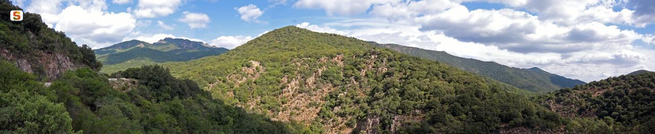
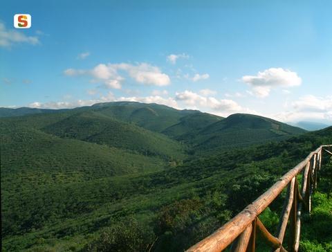
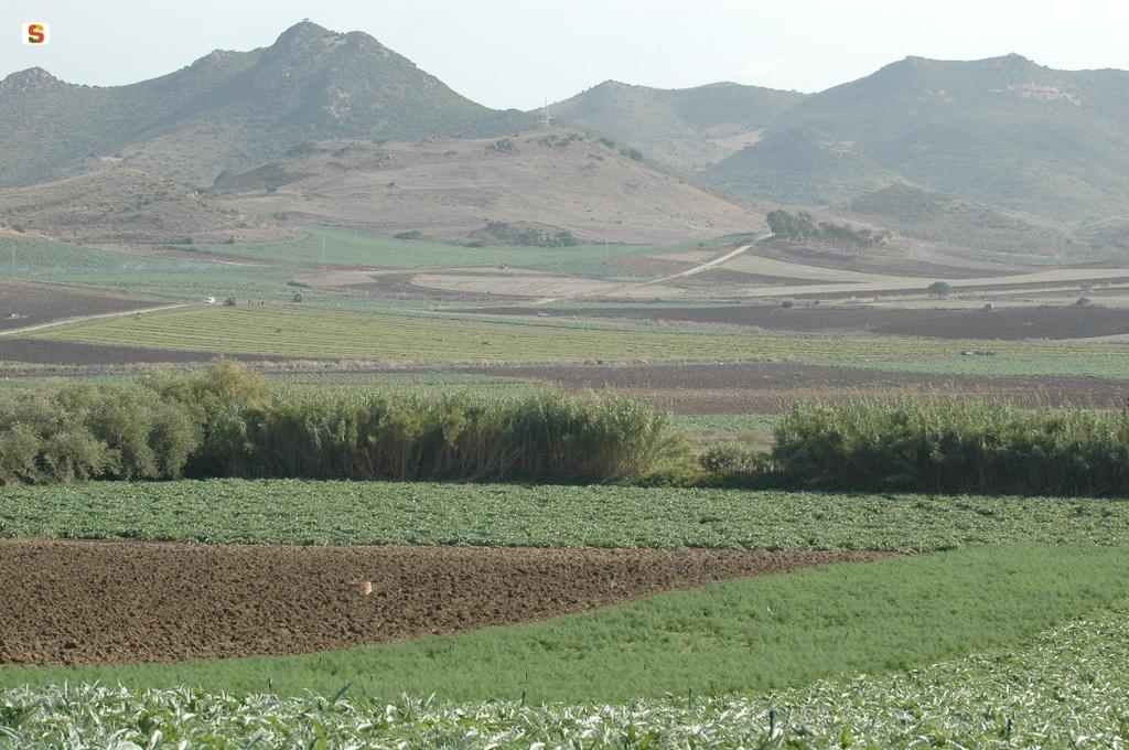
Sulcis is a sub-region of Sardinia, in thesouth-west of the island, and forms an integral part ofthe historical and geographical region of Sulcis-Iglesiente. It takes its name from the ancient Punic city of Sulki or Sulci(the present-day Sant'Antioco). Sulcis propercorresponds to the south-western slope of the Sulcis Mountainsand to the plain below as far as the south-west coast thatoverlooks the Channel of Sardinia from Cape Altano tothe Gulf of Palmas and from here towards Cape Teulada.Due to political-geographical affinities,the Sulcis archipelago is considered part of the sulcitan territory, with the islands ofSan Pietro and Sant'Antioco.Sulcis has a unique characteras it is almost completely bounded by the sea andby the mountain massif of the same name, which isolate it from the restof the region. The border is physically demarcated by a watershedof medium altitude and rugged morphology, which divides Sulcisand Iglesiente and is interrupted by a narrow strip of alluvialdeposits that links Carbonia to Villamassargia.In the west, the morphology is characterised byfloodplains stretching all along the coastal strip,from Porto Pino (Sant'Anna Arresi) to Carbonia and Portoscuso, alternating with gentle hilly reliefs. To the north and east, the morphology is defined by reliefs that transform the landscape abruptly from flat-to-hilly to inaccessible and mountainous (source: Wikipedia).

402394.jpg
slug
sulcis

Campidano di Cagliari

Approximately 10 km outside Cagliari is the Campidano State-owned Forest. It consists of a single large forest covering approximately 1600 hectares, of which 489 fall within the area called Santu Barzolu owned by the municipality of Sinnai and managed by the Forestry Authority. The forest complex borders to the south with the town of Sinnai and Settimo S. Pietro, to the west with Soleminis while to the north-west is the municipality of Dolianova.

The historical body of the state-owned forest was acquired by the forestry administration around 1900 in order to start reforestation work which then continued over the following decades. Of particular interest is the mature pine forest of Aleppo pine at Sa Pira.   At Is Landireddus there is also an area planted with cork oak in 1906.

Passing through Sinnai, from the access located south of the forest, at Sa Pira, you come to Bruncu Mogumu, a panoramic hill which is home to an archaeological site of considerable interest. Nearby you can still see the remains of a building destroyed by a fire in 1997, which devastated a vast area of the forest.
The access from Soleminis, north of the forest, leads to Mount Arrubiu where you can find a plant nursery and the former forestry barracks, renovated and now used for environmental education activities (C.E.E.A.). There is also an abandoned silver mine.
The body of Santu Barzolu, identified as a Site of Community Interest, joins the state-owned forest in the area of  Bruncu Cirronis and Cuccuru sa Cruxitta and extends to the east to include the water catchment area of the Rio Santu Barzolu in the area of the reservoir that supplies the aqueduct.

435731.jpg
slug
campidano-di-cagliari

Campidano di Cagliari

Nelle vicinanze di Cagliari, a circa 10 km, si trova la Foresta Demaniale Campidano. E’ costituita da un unico corpo esteso circa 1600 ettari, di cui 489 ricadenti nella zona denominata Santu Barzolu di proprietà del comune di Sinnai e gestiti dall’Ente Foreste. Il complesso confina a sud con il centro abitato di Sinnai e Settimo S. Pietro, ad ovest con quello di Soleminis mentre a nord-ovest si trova il comune di Dolianova. 

Il corpo storico della foresta demaniale fu acquisito dall’amministrazione forestale intorno al 1900 per l’avvio dei lavori di rimboschimento che sono proseguiti nei decenni successivi. Di particolare interesse la pineta adulta di pino d’Aleppo ubicata a Sa Pira, per la cui realizzazione fu impiegata manodopera costituita da prigionieri austriaci della I guerra mondiale. In località “is Landireddus” si segnala inoltre un’area impiantata a sughera nel 1906. 

Passando da Sinnai, dall’accesso ubicato a sud della foresta, in località Sa Pira, si arriva alla località “Bruncu Mogumu”, un colle panoramico che ospita un sito archeologico di notevole interesse. Nei pressi si incontrano ancora i resti di un fabbricato distrutto dall’incendio del 1997 che ha attraversato la foresta devastandone una vasta area. 
L’accesso da Soleminis, a nord della foresta, porta in località Mont’Arrubiu dove troviamo un vivaio e la ex-caserma forestale ristrutturata e destinata alle attività di educazione ambientale (C.E.E.A.). Sono inoltre presenti i resti di una miniera di argento.
Il corpo di Santu Barzolu, individuato come Sito di Interesse Comunitario, si unisce alla foresta demaniale nella zona di Bruncu Cirronis e Cuccuru sa Cruxitta e si estende ad est a comprendere il bacino imbrifero del Rio Santu Barzolu, nell’area del lago artificiale che alimenta l’acquedotto.

Approximately 10 km outside Cagliari is the Campidano State-owned Forest. It consists of a single large forest covering approximately 1600 hectares, of which 489 fall within the area called Santu Barzolu owned by the municipality of Sinnai and managed by the Forestry Authority. The forest complex borders to the south with the town of Sinnai and Settimo S. Pietro, to the west with Soleminis while to the north-west is the municipality of Dolianova.

The historical body of the state-owned forest was acquired by the forestry administration around 1900 in order to start reforestation work which then continued over the following decades. Of particular interest is the mature pine forest of Aleppo pine at Sa Pira.   At Is Landireddus there is also an area planted with cork oak in 1906.

Passing through Sinnai, from the access located south of the forest, at Sa Pira, you come to Bruncu Mogumu, a panoramic hill which is home to an archaeological site of considerable interest. Nearby you can still see the remains of a building destroyed by a fire in 1997, which devastated a vast area of the forest.
The access from Soleminis, north of the forest, leads to Mount Arrubiu where you can find a plant nursery and the former forestry barracks, renovated and now used for environmental education activities (C.E.E.A.). There is also an abandoned silver mine.
The body of Santu Barzolu, identified as a Site of Community Interest, joins the state-owned forest in the area of  Bruncu Cirronis and Cuccuru sa Cruxitta and extends to the east to include the water catchment area of the Rio Santu Barzolu in the area of the reservoir that supplies the aqueduct.

435731.jpg
slug
campidano-di-cagliari

Marmilla

Marmilla is a sub-region of Sardinia located in the central-southern sector of the region. It is bordered to the east and the south by Campidano, to the north-west by Mount Arci, to the north by Giara di Gesturi and by Giara di Serri, and to the east by Flumini Mannu. The landscape is predominantly hilly and includes the Giara, the Genoni plateau and the Rio Mannu basin.   The main activities in this area are agriculture and tourism. The main crops are cereals, but broad bean cultivation is also widespread. Tourism in Marmilla can count on various environmental assets, numerous nuragic centres and architectural attractions.   Noteworthy attractions include:  Giara of Gesturi and the Mount Arci Natural Park, the Nuragic Village of Su Nuraxi in Barumini, nuraghe Cuccurada in Mogoro, the complex of Genna Maria in Villanovaforru, the fortress of Su Mulinu in Villanovafranca and the nuragic sanctuary of Santa Vittoria in Serri.  Architectural structures such as the Romanesque churches of San Michele Arcangelo in Siddi, San Pietro in Villamar and San Giovanni Battista in Barumini. the Gothic parish churches of San Vito di Gergei, Santa Barbara in Genoni and Beata Vergine Immacolata in Barumini, the Castle of Las Plassas, the 16th century Casa Zapata in Barumini, the entrance portals of the historical residences of Simala, the 'sa corona arrubia museum in Lunamatrona     [source: Wikipedia].

The area includes the municipalities of:  Albagiara, Ales, Baressa, Barumini, Collinas, Curcuris,  Furtei, Genuri, Gesturi, Gonnoscodina, Gonnostramatza, Las Plassas, Lunamatrona, Masullas, Mogoro, Morgongiori, Nureci, Pau, Pauli Arbarei, Pompu, Sanluri, Sardara,  Segariu, Senis, Setzu, Siddi, Simala, Sini, Siris, Tuili, Turri, Ussaramanna, Villamar, Villanovaforru, Villanovafranca.

437822.jpg
slug
marmilla

Marmilla

La Marmilla è una subregione della Sardegna posta nella parte centro-meridionale della regione.

È delimitata ad est e a sud dal Campidano, a nord-ovest dal Monte Arci, a nord dalla Giara di Gesturi e dalla Giara di Serri, a est dal Flumini Mannu.

Il paesaggio è prevalentemente collinare e comprende la Giara, l'altopiano di Genoni ed il bacino del Rio Mannu. Le attività principali della zona sono l'agricoltura ed il turismo. Le coltivazioni sono prevalentemente di cereali, ma è diffusa anche la coltivazione delle fave.

Il turismo nella Marmilla può contare su vari beni ambientali, numerosi centri nuragici, opere architettoniche. Si segnalano in particolare:

  • la Giara di Gesturi ed il Parco Naturale Monte Arci, il Villaggio nuragico di Su Nuraxi a Barumini,
  • il nuraghe Cuccurada a Mogoro, il complesso di Genna Maria a Villanovaforru, la fortezza di Su Mulinu a Villanovafranca, il santuario nuragico di Santa Vittoria a Serri.
  • Opere architettoniche quali le chiese romaniche di  San Michele Arcangelo a Siddi, San Pietro a Villamar e San Giovanni Battista a Barumini
  • chiese parrocchiali gotiche di San Vito di Gergei, Santa Barbara a Genoni e Beata Vergine Immacolata a Barumini,
  • il Castello giudicale di Las Plassas, la casa cinquecentesca Zapata di Barumini, i portali delle dimore storiche di Simala, il museo 'sa corona arrubia' in territorio di Lunamatrona

(fonte: Wikipedia).

Fanno parte di questo territorio i comuni: Albagiara, Ales, Baressa, Barumini, Collinas, Curcuris, Furtei, Genuri, Gesturi, Gonnoscodina, Gonnostramatza, Las Plassas, Lunamatrona, Masullas, Mogoro, Morgongiori, Nureci, Pau, Pauli Arbarei, Pompu, Sanluri, Sardara, Segariu, Senis, Setzu, Siddi, Simala, Sini, Siris, Tuili, Turri, Ussaramanna, Villamar, Villanovaforru, Villanovafranca.

Marmilla is a sub-region of Sardinia located in the central-southern sector of the region. It is bordered to the east and the south by Campidano, to the north-west by Mount Arci, to the north by Giara di Gesturi and by Giara di Serri, and to the east by Flumini Mannu. The landscape is predominantly hilly and includes the Giara, the Genoni plateau and the Rio Mannu basin.   The main activities in this area are agriculture and tourism. The main crops are cereals, but broad bean cultivation is also widespread. Tourism in Marmilla can count on various environmental assets, numerous nuragic centres and architectural attractions.   Noteworthy attractions include:  Giara of Gesturi and the Mount Arci Natural Park, the Nuragic Village of Su Nuraxi in Barumini, nuraghe Cuccurada in Mogoro, the complex of Genna Maria in Villanovaforru, the fortress of Su Mulinu in Villanovafranca and the nuragic sanctuary of Santa Vittoria in Serri.  Architectural structures such as the Romanesque churches of San Michele Arcangelo in Siddi, San Pietro in Villamar and San Giovanni Battista in Barumini. the Gothic parish churches of San Vito di Gergei, Santa Barbara in Genoni and Beata Vergine Immacolata in Barumini, the Castle of Las Plassas, the 16th century Casa Zapata in Barumini, the entrance portals of the historical residences of Simala, the 'sa corona arrubia museum in Lunamatrona     [source: Wikipedia].

The area includes the municipalities of:  Albagiara, Ales, Baressa, Barumini, Collinas, Curcuris,  Furtei, Genuri, Gesturi, Gonnoscodina, Gonnostramatza, Las Plassas, Lunamatrona, Masullas, Mogoro, Morgongiori, Nureci, Pau, Pauli Arbarei, Pompu, Sanluri, Sardara,  Segariu, Senis, Setzu, Siddi, Simala, Sini, Siris, Tuili, Turri, Ussaramanna, Villamar, Villanovaforru, Villanovafranca.

437822.jpg
slug
marmilla

Sarrabus-Sette Fratelli

The area is located in the south-eastern sector of Sardinia, between the historical regions of Sarrabus and Campidano, and administratively speaking, lies within the municipalities of Burcei, Sinnai, San Vito, Dolianova, Settimo San Pietro, Soleminis, Castiadas and Muravera. 
The climate is typically Mediterranean, characteristic of the southern regions of Sardinia, with long, hot dry summers that last for about four months, while the winter is mild with moderate rainfall. The vegetation of the forest complex of Settefratelli is quite varied, with the coastal strip featuring typical Mediterranean maquis with mastic (Pistacia lentiscus L.), the Phoenician juniper (Juniperus phoenicea L.), tree spurge (Euphorbia dendroides L.), sporadic olive tree specimens (Olea europea L. var. sylvestris Brot.) 
and narrow-leaved mock privet (Phyllirea angustifolia L.), while in inland areas the most widespread forest species is the holm oak together with strawberry tree, broad-leaved phyllirea, heather and viburnum. Cork oaks are also found at medium-low elevations. 
Pulvinus vegetation characterises the highest ridges, with Corsican broom, thyme and lavender, with riparian vegetation along streams and rivers including oleander, willows and alder.   Especially in the State-owned forests of Settefratelli and Castiadas, the territory represents a natural habitat of Sardinian deer which have found a safe refuge here and are protected thanks to the conservation work of the Forestry Authority.   In addition to deer, the forests are home to numerous other animal species such as eagle, marten, Sardinian hare, wild boar, partridge and fox.
 

Galleria Immagini Media
bivio per maidopis.jpg
controlli Segnaletica prima della messa in posa.jpg
foto panoramica in loc. Acqueddas lungo sentiero vs aree sperimentali del Life ceduo.JPG
slug
sarrabus-sette-fratelli

Sarrabus-Sette Fratelli

Il territorio si trova nel settore sud-orientale della Sardegna, tra le regioni storiche del Sarrabus e del Campidano, ed è compreso, amministrativamente, nei territori dei Comuni di Burcei, Sinnai, San Vito, Dolianova, Settimo San Pietro, Soleminis, Castiadas e Muravera. 
Il clima è tipicamente mediterraneo, caratteristico delle zone meridionali sarde, con estati calde, lunghe ed asciutte che si protraggono per circa quattro mesi, mentre l’inverno è mite e moderatamente piovoso. 
La vegetazione del complesso forestale di Settefratelli è piuttosto varia presentandosi sulla fascia litoranea con la tipica macchia a lentischio (Pistacia lentiscus L.), col ginepro fenicio (Juniperus phoenicea L.) con l’euforbia arborea (Euphorbia dendroides L.), con sporadici esemplari diolivastro (Olea europea L. var. sylvestris Brot.) e con la fillirea angustifolia (Phyllirea angustifolia L.), mentre nelle aree interne la formazione forestale maggiormente diffusa è la lecceta associata a seconda delle situazioni al corbezzolo, alla fillirea latifoglia, all’erica e al viburno. A quote medio basse si trova anche la sughera. Sui crinali più alti si trova una vegetazione a pulvino con ginestra corsa, timo, lavanda, mente lungo gli alvei dei torrenti la vegetazione riparia a oleandro, salici e ontano.  Il territorio costituisce, soprattutto nelle Foreste Demaniali dei Settefratelli e di Castiadas, uno degli areali di eccellenza del cervo sardo che qui ha trovato rifugio ed è protetto e conservato grazie all’azione dell’Ente Foreste. 
Oltre al cervo, le foreste ospitano numerose altre specie animali come l’aquila, la martora, la lepre sarda, il cinghiale, la pernice e la volpe
 

The area is located in the south-eastern sector of Sardinia, between the historical regions of Sarrabus and Campidano, and administratively speaking, lies within the municipalities of Burcei, Sinnai, San Vito, Dolianova, Settimo San Pietro, Soleminis, Castiadas and Muravera. 
The climate is typically Mediterranean, characteristic of the southern regions of Sardinia, with long, hot dry summers that last for about four months, while the winter is mild with moderate rainfall. The vegetation of the forest complex of Settefratelli is quite varied, with the coastal strip featuring typical Mediterranean maquis with mastic (Pistacia lentiscus L.), the Phoenician juniper (Juniperus phoenicea L.), tree spurge (Euphorbia dendroides L.), sporadic olive tree specimens (Olea europea L. var. sylvestris Brot.) 
and narrow-leaved mock privet (Phyllirea angustifolia L.), while in inland areas the most widespread forest species is the holm oak together with strawberry tree, broad-leaved phyllirea, heather and viburnum. Cork oaks are also found at medium-low elevations. 
Pulvinus vegetation characterises the highest ridges, with Corsican broom, thyme and lavender, with riparian vegetation along streams and rivers including oleander, willows and alder.   Especially in the State-owned forests of Settefratelli and Castiadas, the territory represents a natural habitat of Sardinian deer which have found a safe refuge here and are protected thanks to the conservation work of the Forestry Authority.   In addition to deer, the forests are home to numerous other animal species such as eagle, marten, Sardinian hare, wild boar, partridge and fox.
 

Galleria Immagini Media
bivio per maidopis.jpg
controlli Segnaletica prima della messa in posa.jpg
foto panoramica in loc. Acqueddas lungo sentiero vs aree sperimentali del Life ceduo.JPG
slug
sarrabus-sette-fratelli

Gutturu Mannu

This area extends into the territories of Assemini, Pula, Santadi, Sarroch, Siliqua, Uta and Villa San Pietro in the Special Protection Zone ITB044009 and in the Site of Community Interest ITB001106 (Mount Arcosu Forest).
The Regional Nature Park of Gutturu Mannu is an area of great natural interest and includes the homonymous State-owned forest situated in the southern part of the province of Cagliari. 
The entire forest was included in the Sulcis Natural Park under regional law n. 31/89 considering extensive western territory of the Sardinian deer. Granite massifs of the Paleozoic with deformed morphology and an alternating sequence of valleys and plateaus.  Peaks over a thousand metres high. Abundance of holm oak woods with yews and hollies in the most isolated ravines; cork trees, strawberry trees, phillyrea arborescent and mastic. Mediterranean maquis with heather, arborescent strawberry tree.
With the approval of Regional Law n. 20 of 2014. 
The park covers the territories of the municipalities of Assemini, Pula, Santadi, Sarroch, Siliqua, Uta, Villa San Pietro, Domus de Maria, Capoterra and Teulada.
No less important from a faunistic point of view are the seasonal migrations of the Sardinian deer and wild boar. Also present are the fox, the Sardinian wild cat, the marten, the woodcock, the woodpigeon and red woodpeckers. Mining settlements (Pantaleo), archaeological settlements and settlements of ancient peasant culture. 
In addition, the S.I.C. area. I.T.B. 001105 -'Monte Arcosu Forest' covers approximately 70% of its area and most of the permanent wildlife reserve 'Gutturu Mannu - Monte Arcosu' in accordance with decrees n°102 of 20.07.78 and n°1240 of 15.11.88.

210 - La cresta sotto Monte Maxia_.jpg
slug
gutturu-mannu

Gutturu Mannu

L'area del Parco naturale regionale di Gutturu Mannu si estende nei territori di Pula, Villa San Pietro, Siliqua, Domus De Maria, Uta, Assemini, Santadi, Capoterra, Sarroch e Teulada, nella Zona di Protezione Speciale ITB044009 e nel Sito di Interesse Comunitario ITB001106 (Foresta di Monte Arcosu). Un territorio di elevato interesse naturalistico, comprende al suo interno la omonima Foresta Demaniale, situata nella parte sud della provincia di Cagliari. Altri importanti presidi forestali demaniali sono Pixinamanna, Is Cannoneris, Pantaleo e Monte Nieddu. Tutte le aree forestali sono comprese nel Parco naturale del Sulcis ai sensi della L.R. 31/89 per la presenza di: "esteso areale occidentale del cervo sardo"- "massicci granitici del Paleozoico dalla tormentata morfologia con valloni alternati a pianori" - "vette elevate oltre i mille metri". Ricchissimo di boschi di lecci con frequenza di tassi e agrifogli negli anfratti più remoti; sughere, corbezzoli, filliree arborescenti e lentischi.  Macchia mediterranea con erica e corbezzolo arborescente.

Importante sotto l’aspetto faunistico per le migrazioni stagionali del cervo sardo e del cinghiale. Presenti anche la volpe, il gatto selvatico sardo, la martora, la beccaccia, il colombaccio e picchi rossi.  "Insediamenti minerari (Pantaleo) e insediamenti archeologici e di antica cultura contadina".      Inoltre ricade nell’area S.I.C. I.T.B. 001105 –‘Foresta di Monte Arcosu’ per circa il 70% della sua superficie e (per gran parte) nell’ Oasi permanente di protezione faunistica ‘Gutturu Mannu - Monte Arcosu’ decretati nel 1978 e nel 1988.   In varie località (ad esempio: Is Fenebas, Is Antiogus...) si può usufruire delle aree pic-nic.

This area extends into the territories of Assemini, Pula, Santadi, Sarroch, Siliqua, Uta and Villa San Pietro in the Special Protection Zone ITB044009 and in the Site of Community Interest ITB001106 (Mount Arcosu Forest).
The Regional Nature Park of Gutturu Mannu is an area of great natural interest and includes the homonymous State-owned forest situated in the southern part of the province of Cagliari. 
The entire forest was included in the Sulcis Natural Park under regional law n. 31/89 considering extensive western territory of the Sardinian deer. Granite massifs of the Paleozoic with deformed morphology and an alternating sequence of valleys and plateaus.  Peaks over a thousand metres high. Abundance of holm oak woods with yews and hollies in the most isolated ravines; cork trees, strawberry trees, phillyrea arborescent and mastic. Mediterranean maquis with heather, arborescent strawberry tree.
With the approval of Regional Law n. 20 of 2014. 
The park covers the territories of the municipalities of Assemini, Pula, Santadi, Sarroch, Siliqua, Uta, Villa San Pietro, Domus de Maria, Capoterra and Teulada.
No less important from a faunistic point of view are the seasonal migrations of the Sardinian deer and wild boar. Also present are the fox, the Sardinian wild cat, the marten, the woodcock, the woodpigeon and red woodpeckers. Mining settlements (Pantaleo), archaeological settlements and settlements of ancient peasant culture. 
In addition, the S.I.C. area. I.T.B. 001105 -'Monte Arcosu Forest' covers approximately 70% of its area and most of the permanent wildlife reserve 'Gutturu Mannu - Monte Arcosu' in accordance with decrees n°102 of 20.07.78 and n°1240 of 15.11.88.

210 - La cresta sotto Monte Maxia_.jpg
slug
gutturu-mannu