Accessible trails
Sentieri per tutti...in questa categoria rientrano i sentieri progettati o riadattati perchè il contatto con l'ambiente naturale sia sempre di stimolo al miglioramento della vita personale di chiunque, con attenzione alle condizioni di disabilità motoria, sensoriale o della sfera psichica e relazionale...

Image credits Sardegna Digital Library Regione Sardegna
Results
Aritzo, Texile. The natural monument
Itinerary
Access
You commence the walk from the centre of Aritzo by taking Via Garibaldi, easily reached in the lower part of the village, then turning left once you reach the small panoramic square of Sant'Antonio, from which you can clearly distinguish the rocky taccu of Texile on the other side of the valley, the destination of the excursion. You continue down a narrow lane that leaves the last houses behind, immediumtely entering terraced allotments, dense hazelnut groves and tall walnut trees, splendid in autumn for their intense foliage.
The springs
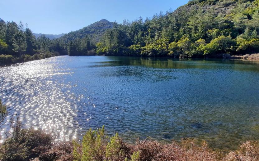
The descent is interrupted at an opening near the Giaria spring. Here, the route continues initially slightly uphill and on a sometimes concreted road always in a beautiful wooded environment despite its proximity to the village. In addition, to the essences already observed, there are dense holly trees and splendid specimens of chestnut and alder. You come to a fork where you turn right, slightly downhill on a cobbled road, following the signs for the Funtana de Zia Albara. Another stretch through hazel groves and terraced allotments separates this junction from the beautiful spring. Take a right here, also meeting the signs for Texile. Gradually descend, first encountering a picnic area near which the monumental Addalcia pine, which unfortunately recently fell to the ground. At a ford, a last spring is finally encountered.
Texile
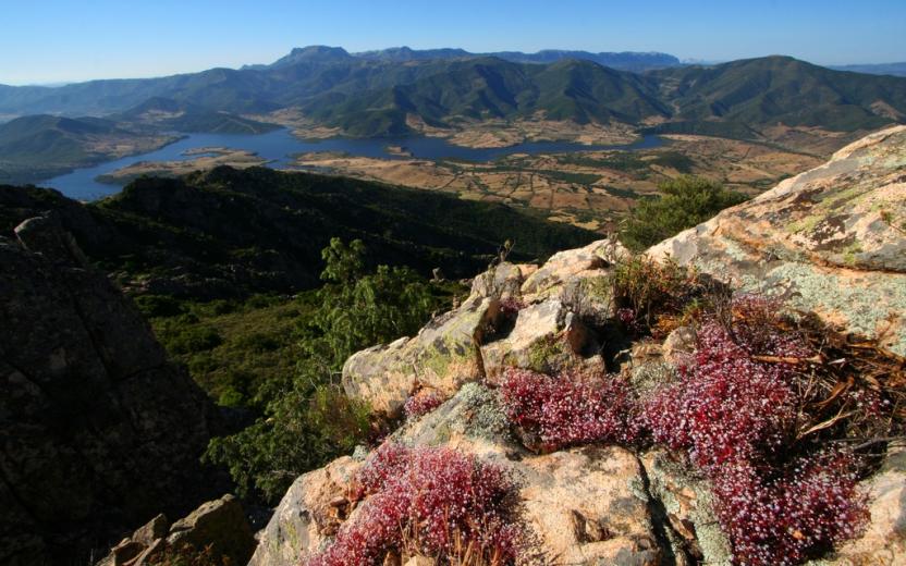
Once past the ford, the dirt road worsens slightly and begins to climb, making a wide hairpin bend but always remaining defined. Ignore minor detours occasionally encountering some signs for Texile and keeping to the south-west direction until one can clearly distinguish the limestone peak above, which is reached at the top of the ascent. The geological peculiarity of Texile is that, similar to many taccos in Ogliastra and the Barbagia di Belvì and Seulo, it is completely isolated from similar rocks and is an island completely unique to its surroundings, consisting as it does of limestone and resting on Palaeozoic schists. This has allowed a rare and peculiar flora to vegetate only on its walls, making Texile a treasure chest of biodiversity, which has therefore become an SCI area (Site of Community Importance) and strictly protected. For the more intrepid, a rocky gully allows access to the summit, from which an extraordinary view of Aritzo, Belvì, the Gennargentu peaks and the Uatzo valley can be admired. On the summit of the peak one can also find numerous ceramics from the proto-historic period, which testifies to ancient settlements or places of worship on the mountain. After a long panoramic rest, you finally return to the village by the same route as the outward journey.
Tipologia itinerario
- Log in to post comments
Photogallery
aritzo - il paese visto da Texile.jpg
aritzo - texile.jpg
aritzo - vista da sotto la cima.jpg
Aritzo veduta di Ignazio Trincas.jpg
211133.jpg
Aritzo, paesaggio autunnale in prossimità della chiesa di Santa Maria.jpg
Monumento naturale di Texile (foto Curreli M.) 2 .jpg
Monumento naturale di Texile (foto Curreli M.).jpg
Aritzo, monumento naturale Texile( foto Cabiddu G.).jpg
Aritzo, veduta del paese da Texile.jpg
Aritzo, Texile, Il monumento naturale
Accesso
Si inizia a camminare dal centro abitato di Aritzo si prende la via Garibaldi, facilmente raggiungibile nella parte bassa del paese, svoltando poi a sinistra una volta raggiunta la piazzetta panoramica di Sant’Antonio, dalla quale si distingue chiaramente il taccu roccioso di Texile dall’altra parte della vallata, meta dell’escursione.
Si prosegue scendendo per uno stretto viottolo che si lascia le ultime case alle spalle, inoltrandosi subito tra orti terrazzati, fitti noccioleti o alti noci, splendidi in autunno per il loro intenso foliage.
Le sorgenti
La discesa si interrompe in uno slargo presso la sorgente di Giaria. Qui si prosegue inizialmente in leggera salita e su fondo talvolta pavimentato, sempre in bell’ambiente boscoso pur nella sua vicinanza al paese ed alle essenze già osservate si aggiungono i fitti agrifogli e splendidi esemplari di castagno ed ontano. Si incontra un bivio dove si prende a destra, in leggera discesa su strada selciata, seguendo le indicazioni per la Funtana de Zia Albara.
Ancora un tratto tra i noccioleti e gli orti terrazzati separa questo incrocio dalla bella sorgente. Qui si prende a destra, incontrando anche le indicazioni per Texile. Si scende gradualmente, incontrando prima un’area pic nic presso la quale era presente il pino monumentale di Addalcia, purtroppo rovinato al suolo recentemente. Presso un guado si incontra infine un’ultima sorgente.
Texile
Superato il guado la sterrata peggiora leggermente e comincia a salire, compiendo un ampio tornante ma rimanendo sempre evidente. Si trascurano deviazioni minori, incontrando saltuariamente alcune indicazioni per Texile e tenendo la direzione sudovest fino a distinguere chiaramente il picco calcareo soprastante che si raggiunge al culmine della salita.
La particolarità geologica di Texile è quella, simile a molti taccos dell’Ogliastra e della Barbagia di Belvì e Seulo, di essere completamente isolato da rocce simili, costituito com’è da calcari e poggiante sugli scisti paleozoici. Questo ha permesso ad una flora rara e peculiare di vegetare solo sulle sue pareti, rendendo Texile uno scrigno di biodiversità, divenuto perciò area SIC e rigorosamente protetto.
Per i più intrepidi, un canalino roccioso permette di accedere alla sommità da cui si ammira una vista straordinaria su Aritzo, Belvì, le vette del Gennargentu e la vallata di Uatzo. Sulla sommità del picco si ritrovano inoltre numerose ceramiche di epoca protostorica a segnalare antichissimi insediamenti o luoghi di culto sulla montagna.
Dopo una lunga sosta panoramica si ritorna infine in paese per la stessa via dell’andata.
Tipologia itinerario
- Log in to post comments
Photogallery
aritzo - il paese visto da Texile.jpg
aritzo - texile.jpg
aritzo - vista da sotto la cima.jpg
original_7638aaae-2c4b-4357-926b-ca92069038e8_IMG_20220325_101130.jpg
texile, panorama dal tacco.jpg
Aritzo veduta di Ignazio Trincas.jpg
Aritzo, veduta del paese da Texile.jpg
211133.jpg
Monumento naturale di Texile (foto Curreli M.).jpg
Aritzo, paesaggio autunnale in prossimità della chiesa di Santa Maria.jpg
Monumento naturale di Texile (foto Curreli M.) 2 .jpg
Sentiero Italia (Stage Z16) Sa Senipida - Ilodei Malu (Caserma Montes)
Overview of the itinerary
Sentiero Italia runs the length of the island’s eastern side, covering its most important mountains, in 28 stages. Starting from the north: it flanks the Monte Limbara massif, crosses the limestones of Mont’Albo and Tuttavista, skirting the Gulf of Orosei, it crosses the Supramonte, Gennargentu and the Tacchi of Ogliastra and reaches Perdasdefogu. Further south, it passes through Armungia and the Gerrei sub-region. Lastly, it touches on the villages of Burcei and San Gregorio, continuing on the Sette Fratelli massif to the old prisons of Castiadas.
General information on Sentiero Italia (Grand Italian Trail)
Sentiero Italia, or Grand Italian Trail, as also explained on the official website, is a walking route that crosses the whole of Italy, using mainly but not exclusively “registered trails”.
In particular, in Sardinia, not all the stages of the Sentiero Italia of CAI (Italian Alpine Club) are made of trails already included in the registry of the Sardinia Trail Network (RES), either because they have not yet been tested and approved or simply because they cannot be registered as they do not meet the requirements. However, as a whole, the Sentiero Italia is the single longest walking route currently crossing Sardinia from the north (S. Teresa Gallura, stage Z 1) to the south (Castiadas, end of stage Z 28), touching on the most fascinating mountain areas in central-eastern Sardinia: the plateau of Buddusò, Tepilora, the Cedrino river valley, the ancient forests of Montes, Perda Liana and the regional forest of Montarbu, Monte Genis, and lastly the regional forest of Settefratelli (among the many crossed by the various stages of this long hiking itinerary).
Information on this stage of the trail
The planned stop point at the cuile Sa Sinipida can currently be used as a camping point, with a spring nearby. For support, please contact Efisio Manca, mobile 3202745951.
The route begins with an easy dirt track that leads to the crossing of the Badde Tureddu stream and then winds uphill passing a spring. At 987 m asl, trail 441 leaves the dirt track and enters the forest. A beautiful trail through a forest of holm oaks and cork trees with route markings on trees and stone cairns. Once past the forest, continue along the trail that becomes a dirt track just before the camping point of ziu Mulittu (two fairly comfortable stone huts).
At the 441-441C fork, continue north-west on 441 towards the ruins of the cuile (sheepfold) of Sos Pisanos and then go up towards Monte Novo San Giovanni where a fire lookout overlooks a vast unspoilt territory. After leaving Monte Novo, continue south-west towards Monte Fumai, at 1316 m asl, and then head north towards the forest ranger station of Montes (Ilodei Malu).
Informazioni utili
Tipologia itinerario
- Log in to post comments
Photogallery
Sentiero Italia (Tappa Z16) Sa Senipida - Ilodei Malu (Caserma Montes)
In sintesi
Il Sentiero Italia attraversa in lunghezza il settore orientale dell’isola toccandone i sistemi montuosi più rilevanti, in 28 tappe. Partendo da nord: tocca il massiccio del Monte Limbara, attraversa i calcari del Mont'Albo e del Tuttavista sfiorando il Golfo di Orosei, attraversa il Supramonte, il Gennargentu, i Tacchi dell’Ogliastra e giunge a Perdasdefogu. Più a sud, transita da Armungia e dalla subregione del Gerrei. Infine tocca l’abitato di Burcei e San Gregorio, per continuare nel massiccio dei Sette Fratelli fino alle vecchie carceri di Castiadas.
Informazioni generali sull'itinerario sentiero Italia
Il Sentiero Italia, come spiegato anche nel sito ufficiale, è un itinerario (o Cammino) lungo tutta l'Italia, che utilizza prevalentemente ma non esclusivamente "sentieri accatastati".
In particolare, in Sardegna, non tutte le tappe del Sentiero Italia del CAI coincidono con sentieri già inseriti nel catasto della Rete Escursionistica della Sardegna (RES), perché non hanno ancora superato le verifiche di percorribilità oppure semplicemente perché non possono essere accatastati non avendone i requisiti. Tuttavia, nel suo insieme, il Sentiero Italia rappresenta l'unica, la più grande dorsale escursionistica che attraversa attualmente la nostra Isola da nord (S. Teresa Gallura, tappa Z 1) a sud (Castiadas, fine tappa Z 28) toccando le aree montane della Sardegna centro-Orientale più affascinanti: l'altopiano di Buddusò, Tepilora, la valle del Cedrino, i boschi vetusti di Montes, Perda Liana e la foresta demaniale di Montarbu, il Monte Genis, e infine la foresta demaniale di Settefratelli (tra le tante attraversate dal lungo itinerario escursionistico a tappe).
Info sul percorso di questa tappa
Il posto tappa previsto al cuile Sa Sinipida è attualmente utilizzabile come bivacco con presenza di sorgente nei pressi. Per assistenza è necessario contattare Efisio Manca, cell. 3202745951.
Il percorso inizia con una agevole sterrata che porta ad attraversare il rio Badde Tureddu per poi risalire con una serie di tornanti lungo i quali si trova una sorgente. Arrivati a quota 987 slm il sentiero 441 lascia la sterrata ed entra nel bosco. Un bel sentiero in mezzo ad un bosco di lecci e sughere segnalato da segnavia su alberi e da omini in pietra. Superato il bosco si continua sul sentiero che diventa sterrata poco prima dei bivacchi di ziu Mulittu (due costruzioni in pietra abbastanza confortevoli).
Arrivati al bivio 441-441C si continua sul 441 in direzione nord-ovest verso le rovine del cuile Sos Pisanos per poi risalire verso Monte Novo San Giovanni dove è presente una vedetta antincendio che domina un vasto territorio incontaminato. Lasciato Monte Novo si prosegue in direzione sud-ovest verso Monte Fumai , 1316 slm, per poi proseguire in direzione nord verso la caserma forestale di Montes (Ilodei Malu).
Informazioni utili
Lungo il percorso non sarà sempre presente la copertura telefonica
Tipologia itinerario
- Log in to post comments
Photogallery
Contiene carte
Spento
Sentiero Italia (Stage Z21B) Ulassai - Jerzu
Overview of the itinerary
Sentiero Italia runs the length of the island’s eastern side, covering its most important mountains, in 28 stages. Starting from the north: it flanks the Monte Limbara massif, crosses the limestones of Mont’Albo and Tuttavista, skirting the Gulf of Orosei, it crosses the Supramonte, Gennargentu and the Tacchi of Ogliastra and reaches Perdasdefogu. Further south, it passes through Armungia and the Gerrei sub-region. Lastly, it touches on the villages of Burcei and San Gregorio, continuing on the Sette Fratelli massif to the old prisons of Castiadas.
General information on Sentiero Italia (Grand Italian Trail)
Sentiero Italia, or Grand Italian Trail, as also explained on the official website, is a walking route that crosses the whole of Italy, using mainly but not exclusively “registered trails”.
In particular, in Sardinia, not all the stages of the Sentiero Italia of CAI (Italian Alpine Club) are made of trails already included in the registry of the Sardinia Trail Network (RES), either because they have not yet been tested and approved or simply because they cannot be registered as they do not meet the requirements. However, as a whole, the Sentiero Italia is the single longest walking route currently crossing Sardinia from the north (S. Teresa Gallura, stage Z 1) to the south (Castiadas, end of stage Z 28), touching on the most fascinating mountain areas in central-eastern Sardinia: the plateau of Buddusò, Tepilora, the Cedrino river valley, the ancient forests of Montes, Perda Liana and the regional forest of Montarbu, Monte Genis, and lastly the regional forest of Settefratelli (among the many crossed by the various stages of this long hiking itinerary).
Information on this stage of the trail
The original stage was quite long, more than 28 km, so it has been split into two parts.
Route 21B is the shortest section, about 10 km, ending in the small town of Ulassai, home to artist Maria Lai and a rock climbing mecca with many bolted routes of varying levels of difficulty.
Leaving the town of Ulassai, follow a short stretch of via S’Arenargiu, where a weaving workshop is located, and a little further on, the fork for Monte Matzeu, which you should leave to your right to continue on a dirt track in a southerly direction. You will then take a path, still heading south, through a beautiful forest with the route sufficiently marked with stone cairns and, passing alongside Monte Tisiddu, you will come to a dirt track that leads, after passing several forks, to an easy path heading south-east. In this section you will find two springs, the first near a hut and the second near a small wooden cabin that can be used as a camping point if necessary.
After passing alongside road SP 13, cross it to continue uphill on a stretch of paved road. At a crossroads, turn right in a westerly direction. Once you have passed a gate with a side passage and the fork leading to the fire lookout, you will find a fork with a scenic spot on the right.
Back to the fork, continue in a westerly direction and then in a south-westerly direction towards the hotel-restaurant Rifugio d’Ogliastra (open all year round). You will then arrive at the stop point in the square of the country church of Sant’Antonio of Jerzu where there is a drinking fountain.
Informazioni utili
Tipologia itinerario
- Log in to post comments
Photogallery
Sentiero Italia (Tappa Z21B) Ulassai - Jerzu
In sintesi
Il Sentiero Italia attraversa in lunghezza il settore orientale dell’isola toccandone i sistemi montuosi più rilevanti, in 28 tappe. Partendo da nord: tocca il massiccio del Monte Limbara, attraversa i calcari del Mont'Albo e del Tuttavista sfiorando il Golfo di Orosei, attraversa il Supramonte, il Gennargentu, i Tacchi dell’Ogliastra e giunge a Perdasdefogu. Più a sud, transita da Armungia e dalla subregione del Gerrei. Infine tocca l’abitato di Burcei e San Gregorio, per continuare nel massiccio dei Sette Fratelli fino alle vecchie carceri di Castiadas.
Informazioni generali sull'itinerario sentiero Italia
Il Sentiero Italia, come spiegato anche nel sito ufficiale, è un itinerario (o Cammino) lungo tutta l'Italia, che utilizza prevalentemente ma non esclusivamente "sentieri accatastati".
In particolare, in Sardegna, non tutte le tappe del Sentiero Italia del CAI coincidono con sentieri già inseriti nel catasto della Rete Escursionistica della Sardegna (RES), perché non hanno ancora superato le verifiche di percorribilità oppure semplicemente perché non possono essere accatastati non avendone i requisiti. Tuttavia, nel suo insieme, il Sentiero Italia rappresenta l'unica, la più grande dorsale escursionistica che attraversa attualmente la nostra Isola da nord (S. Teresa Gallura, tappa Z 1) a sud (Castiadas, fine tappa Z 28) toccando le aree montane della Sardegna centro-Orientale più affascinanti: l'altopiano di Buddusò, Tepilora, la valle del Cedrino, i boschi vetusti di Montes, Perda Liana e la foresta demaniale di Montarbu, il Monte Genis, e infine la foresta demaniale di Settefratelli (tra le tante attraversate dal lungo itinerario escursionistico a tappe).
Info sul percorso di questa tappa
La tappa originaria essendo abbastanza lunga, oltre 28 km, si è preferito suddividerla in due parti.
La 21B rappresenta il tratto più corto, circa 10 km e ben si presta per accogliere l’escursionista a inizio tappa nel centro abitato di Ulassai, il paese dell’artista Maria Lai e località con numerose vie su parete con vari gradi di difficoltà.
Lasciato il centro abitato di Ulassai si percorre un breve tratto di via S’Arenargiu, dove si trova il laboratorio di tessitura, ed poco più avanti il bivio per Monte Matzeu che lasceremo alla nostra destra per proseguire su una sterrata in direzione Sud. Successivamente si percorre un sentiero, sempre in direzione Sud, che attraversa un bel bosco con il percorso sufficientemente individuato con omini di pietra e, costeggiando il Monte Tisiddu si arriva a percorrere una sterrata che ci porta, dopo aver superato alcuni bivi, ad un agevole sentiero in direzione Sud-Est. In questo tratto troviamo due sorgenti, la prima in prossimità di un capanno e la seconda nei pressi di una casetta in legno che in caso di necessità può essere utilizzata come bivacco.
Dopo aver costeggiato la SP 13 la si attraversa per proseguire in salita su tratto di strada cementata. Arrivati ad un quadrivio si prende a destra in direzione Ovest. Superato un cancello con passaggio laterale ed il bivio che porta alla vedetta antincendio troviamo un bivio con una zona panoramica sulla destra.
Ritornati al bivio continuiamo in direzione Ovest, successivamente verso Sud e poi in direzione Sud-Ovest verso l’hotel Ristorante Rifugio d'Ogliastra (aperto tutto l’anno) e successivamente arrivare al posto tappa nel piazzale della chiesa campestre di Sant’Antonio di Jerzu dove è presente una fontanella.
Informazioni utili
Lungo il percorso non sarà sempre presente la copertura telefonica
Tipologia itinerario
- Log in to post comments
Photogallery
Contiene carte
Spento