Start website main content

Accessible trails

1 pathway

Sentieri per tutti...in questa categoria rientrano i sentieri progettati o riadattati perchè il contatto con l'ambiente naturale sia sempre di stimolo al miglioramento della vita personale di chiunque, con attenzione alle condizioni di disabilità motoria, sensoriale o della sfera psichica e relazionale...

Rio Ermolinos.jpg

Results

CMSB – STAGE 12 - FROM ARENAS TO SU MANNAU

This stage introduces an extraordinary new route that enriches your journey from a natural-environmental and cultural-historical point of view.

Holm oak woods on the limestone mountains, the great perennial spring of Pubusinu and the caves of Su Mannau are the natural jewels that form the backdrop of the mining heritage characterized by the mine of Gutturu Pala, together with the house of Karl Marx who discovered it, and the mine-museum of Su Zurfuru.

You’ll have the chance to devote time to visiting such a heritage thanks to this easy and mostly downhill stage.

Safety and useful tips

The route is easy to follow and runs along an accessible comfortable dirt road.

At the start of the stage, you will come across the ruins of old mining activities and, a little further on, the buildings of the old Genne Carru Mine; avoid crossing any fences and/or venturing inside but always admire them from a distance without leaving the Trail.

Informazioni utili

The stage presents a low difficulty. The route has a length of 13.3 km which can be covered in 4 hours and an uphill difference in height of 399 m and a downhill difference of 788 m.

FOR UPDATED INFORMATION, CONSULT THE STAGE SHEET ON THE OFFICIAL WEBSITE

Lenght 13.300 m

Links

CMSB tappa-12-da-arenas-su-mannau.gpx

Total elevation gain 646 metri

Geographical area Iglesiente

Elevation gain 399 metri

Negative elevation 788 metri

CMSB – TAPPA 12: DA ARENAS A SU MANNAU

Con questa tappa viene aperto un nuovo straordinario percorso che arricchisce il Cammino sotto l’aspetto naturalistico-ambientale e storico-culturale.

I boschi di leccio sulle montagne calcaree, la grande sorgente perenne di Pubusinu e le grotte di Su Mannau sono i gioielli naturali che fanno da cornice al patrimonio minerario segnato dalla miniera di Gutturu Pala con la casa di Carlo Marx che fu il suo scopritore e la miniera-museo di Su Zurfuru.

Trattandosi di una tappa facile e prevalentemente in discesa è quindi possibile dedicare tempo alla visita di questo patrimonio storico ed ambientale.

Informazioni utili

La tappa presenta una bassa difficoltà. Il percorso ha una lunghezza di 13,3  km percorribili in 4 ore  e un  dislivello  in salita di 399 m e in discesa  di 788 m.
PER LE INFORMAZIONI AGGIORNATE, CONSULTA LA SCHEDA DELLA TAPPA, SUL SITO UFFICIALE 

Il Cammino Minerario di Santa Barbara

Si tratta del primo, tra i cammini sardi, ad essere stato iscritto al registro istituito dalla Regione Sarda nel 2012 con DGR48/9 ("Registro dei cammini di Sardegna, degli itinerari religiosi e dello spirito"). Attualmente è gestito dall'omonima Fondazione.

LA STORIA DEL PROGETTO

L’idea di costruire un itinerario nell’area più estesa e rappresentativa del Parco Geominerario Storico Ambientale della Sardegna, il Sulcis-Iglesiente-Guspinese, riscoprendo gli antichi cammini minerari oggi in gran parte abbandonati, è nata dai volontari dell’Associazione ONLUS Pozzo Sella Per il Parco Geominerario a seguito della grande partecipazione dei cittadini alle escursioni organizzate dalla stessa associazione dopo aver reso fruibili numerosi percorsi minerari.

Con il Cammino Minerario di Santa Barbara si vuole perseguire l’obiettivo di tramandare la memoria degli uomini che nei secoli e nei millenni passati hanno realizzato e percorso gli antichi cammini minerari con il piacere di riscoprire a passo lento la bellezza del territorio.

Un Protocollo d’intesa è stato sottoscritto tra i Comuni di Iglesias, Buggerru, Fluminimaggiore, Arbus, Guspini, Gonnosfanadiga, Villacidro, Domusnovas, Musei, Villamassargia. Narcao, Nuxis, Santadi, Piscinas, Giba, Masainas, San Giovanni Suergiu, Sant’Antioco, Carbonia e Gonnesa, le Diocesi di Iglesias e di Ales Terralba, le Province di Carbonia Iglesias e del Medio Campidano, il Consorzio del Parco Geominerario Storico Ambientale della Sardegna, l’ANCI SARDEGNA e l’Associazione Pozzo Sella: si tratta di un  partenariato per la costruzione e la gestione dell’itinerario storico, culturale, ambientale e religioso denominato “Cammino Minerario di Santa Barbara”.

PER MAGGIORI INFORMAZIONI, DETTAGLI E INFO AGGIORNATE SULLE TAPPE

Si consiglia di consultare il sito ufficiale del cammino: www.camminominerariodisantabarbara.org/

Lenght 13.300 m

Links

CMSB tappa-12-da-arenas-su-mannau.gpx

Total elevation gain 646 metri

Roadbook

Da Arenas il percorso scende dolcemente passando attraverso la Foresta Demaniale di Gutturu Pala - Pubusinu gestita dall'Agenzia Fo.re.S.T.A.S. dove  sono presenti numerosi resti minerari testimonianza di un’intensa attività passata, la quale rappresentava la principale risorsa economica per la popolazione locale.

Geographical area Iglesiente

Elevation gain 399 metri

Negative elevation 788 metri

Sentiero Italia (Stage Z21A) Taquisara - Ulassai

Overview of the itinerary

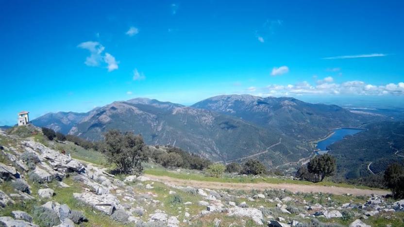
Sentiero Italia runs the length of the island’s eastern side, covering its most important mountains, in 28 stages.  Starting from the north: it flanks the Monte Limbara massif, crosses the limestones of Mont’Albo and Tuttavista, skirting the Gulf of Orosei, it crosses the Supramonte, Gennargentu and the Tacchi of Ogliastra and reaches Perdasdefogu.  Further south, it passes through Armungia and the Gerrei sub-region. Lastly, it touches on the villages of Burcei and San Gregorio, continuing on the Sette Fratelli massif to the old prisons of Castiadas.

General information on Sentiero Italia (Grand Italian Trail)

Sentiero Italia, or Grand Italian Trail, as also explained on the official website, is a walking route that crosses the whole of Italy, using mainly but not exclusively “registered trails”.   
In particular, in Sardinia, not all the stages of the Sentiero Italia of CAI (Italian Alpine Club) are made of trails already included in the registry of the Sardinia Trail Network (RES), either because they have not yet been tested and approved or simply because they cannot be registered as they do not meet the requirements.  However, as a whole, the Sentiero Italia is the single longest walking route currently crossing Sardinia from the north (S. Teresa Gallura, stage Z 1) to the south (Castiadas, end of stage Z 28), touching on the most fascinating mountain areas in central-eastern Sardinia: the plateau of Buddusò, Tepilora, the Cedrino river valley, the ancient forests of Montes, Perda Liana and the regional forest of Montarbu, Monte Genis, and lastly the regional forest of Settefratelli (among the many crossed by the various stages of this long hiking itinerary).

Information on this stage of the trail

The original stage was quite long, around 28 km, so it has been split into two parts. 

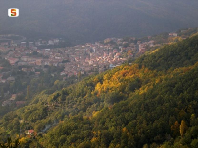
Route 21A is the longest section, about 17 km, ending in the small town of Ulassai, home to artist Maria Lai and a climbing mecca with many bolted routes of varying levels of difficulty. 

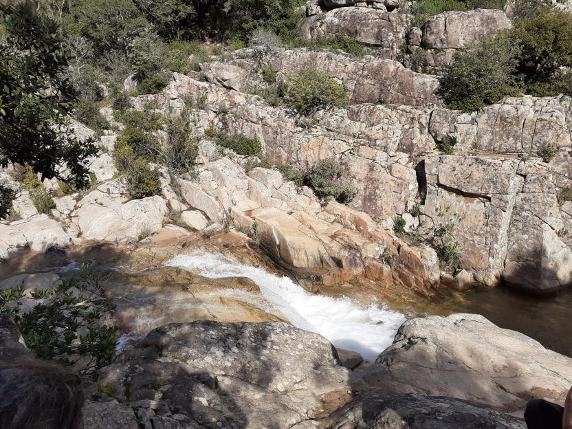
The start point is close to the town park, where there is also a fountain. The route starts uphill, along a clearly marked path. The first destination is nuraghe Serbissi, at an elevation of 947 m asl. Having left the nuraghe, which is managed by a local cooperative, the path turns downhill and then after a series of easy ascents and descents, reaches the Urceni nuraghe (934 m asl). Here you will find a fork; take the southern path and after a brief stop at the Urceni fountain, continue in the direction of the San Giorgio hotel (only open in summer). After a few hundred metres, you can stop for a picnic at the abundant Sa Brecca spring

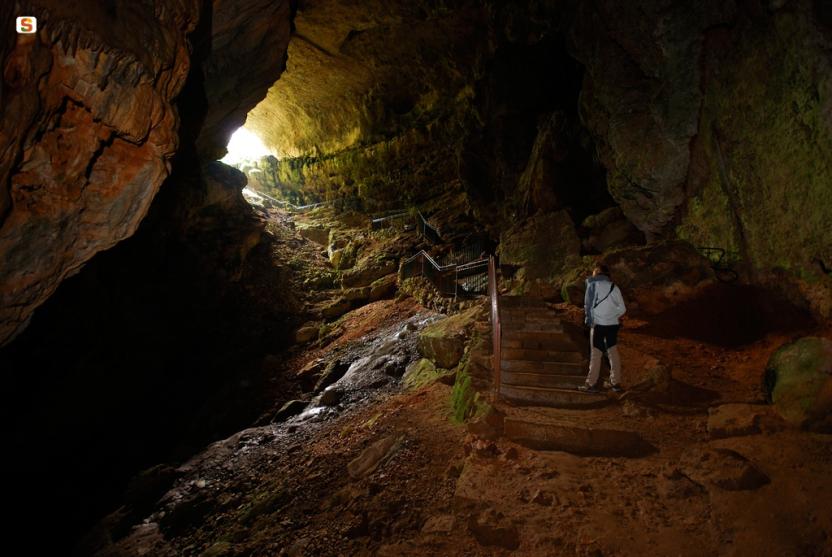
On the way to the car park of the Cave of Su Marmuri, you will encounter the Sanu nuraghe, which does not offer much opportunity at the moment for viewing or exploration because it has not yet undergone archaeological excavations. From the cave’s car park, walk along a short stretch of blacktop road, which you will then leave to take the path that, running alongside the sports field, offers beautiful views of the town. This final section is known as the Maria Lai trail

This is a very scenic stage suitable for fairly fit hikers. The final section, from the sports field onwards, is recommended for experienced hikers as there are two exposed stretches, albeit equipped with a steel cable.

Lenght 15.200 m

SI Z21-A.gpx

Total elevation gain 663 metri