Accessible trails
Sentieri per tutti...in questa categoria rientrano i sentieri progettati o riadattati perchè il contatto con l'ambiente naturale sia sempre di stimolo al miglioramento della vita personale di chiunque, con attenzione alle condizioni di disabilità motoria, sensoriale o della sfera psichica e relazionale...

Image credits Sardegna Digital Library Regione Sardegna
Results
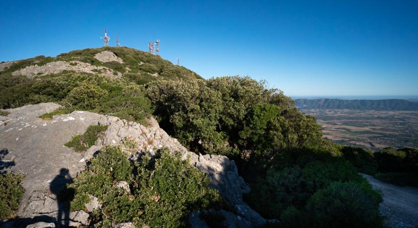
Sentiero Italia (Stage Z15) Monte Maccione - Sa Senipida
Overview of the itinerary
Sentiero Italia runs the length of the island’s eastern side, covering its most important mountains, in 28 stages. Starting from the north: it flanks the Monte Limbara massif, crosses the limestones of Mont’Albo and Tuttavista, skirting the Gulf of Orosei, it crosses the Supramonte, Gennargentu and the Tacchi of Ogliastra and reaches Perdasdefogu. Further south, it passes through Armungia and the Gerrei sub-region. Lastly, it touches on the villages of Burcei and San Gregorio, continuing on the Sette Fratelli massif to the old prisons of Castiadas.
General information on Sentiero Italia (Grand Italian Trail)
Sentiero Italia, or Grand Italian Trail, as also explained on the official website, is a walking route that crosses the whole of Italy, using mainly but not exclusively “registered trails”.
In particular, in Sardinia, not all the stages of the Sentiero Italia of CAI (Italian Alpine Club) are made of trails already included in the registry of the Sardinia Trail Network (RES), either because they have not yet been tested and approved or simply because they cannot be registered as they do not meet the requirements. However, as a whole, the Sentiero Italia is the single longest walking route currently crossing Sardinia from the north (S. Teresa Gallura, stage Z 1) to the south (Castiadas, end of stage Z 28), touching on the most fascinating mountain areas in central-eastern Sardinia: the plateau of Buddusò, Tepilora, the Cedrino river valley, the ancient forests of Montes, Perda Liana and the regional forest of Montarbu, Monte Genis, and lastly the regional forest of Settefratelli (among the many crossed by the various stages of this long hiking itinerary).
Information on this stage of the trail
After retracing, this time uphill, your steps along trail 401 and arriving at the junction with trail 406 (Su Punteddu locality), continue south on trail 401 towards the Tuones locality. From this locality, follow the steep winding path of Iscala ‘e Pradu that leads you to the Corrasi mountain (the highest peak of the Supramonte, 1463 m asl). After crossing the Corrasi in a S-SE direction, with the town of Orgosolo in the background, you will meet the fork with trail 404, which links to the steep stretch of Iscala ‘e Marras. Continue along trail 402, still heading S-SE, to arrive at Iscala ‘e s’Arenargiu near which stands a small natural arch overlooking (the height here is 1113 m asl) the valley below.
Leaving to the left the fork leading to punta Solitta, head south towards punta Sa Pruna, 1389 m asl and punta Lolloine, 1351 m asl (Supramonte di Orgosolo). After Fruncu sos Cuzos, at 1367 m asl, the descent towards cuile Sa Sinipida begins. During the descent, more than 1 km from Fruncu sos Cuzos, is the Nurra (chasm) de Adarre (N40.15564° E9.42790°).
The planned stop point at the cuile Sa Sinipida can currently be used as a camping point, with a spring nearby. For support, please contact Efisio Manca, mobile 320274595
Informazioni utili
Itinerary roadbook
Tipologia itinerario
- Log in to post comments
Photogallery
Sulla punta del Corrasi.jpg
Sulla cima del Corrasi, nei pressi del bivio 401-402.jpg
lo sconfinato paesaggio del Supramonte tra Pradu e Punta Corrasi.jpg
shutterstock_92302996_corrasi_marmo_81.jpg
Bivio Tuones a 1025 mslm.jpg
La splendida area di sosta a Tuones.jpg
area di sosta Tuones.jpg
Tuones e oliena visti da quota 1200 lungo il sentiero 401.jpg
arrivo a Pradu, sguardo verso Oliena.jpg
prospettiva panoramica lato nord supramonte oliena.jpg
Su Carmene (Oliena) partenza B-401.jpg
Tuones e oliena visti da quota 1200 lungo il sentiero 401.jpg
Hinele, partenza da Oliena del 403.jpg
oliena.jpg
Sentiero Italia (Tappa Z15) Monte Maccione - Sa Senipida
In sintesi
Il Sentiero Italia attraversa in lunghezza il settore orientale dell’isola toccandone i sistemi montuosi più rilevanti, in 28 tappe. Partendo da nord: tocca il massiccio del Monte Limbara, attraversa i calcari del Mont'Albo e del Tuttavista sfiorando il Golfo di Orosei, attraversa il Supramonte, il Gennargentu, i Tacchi dell’Ogliastra e giunge a Perdasdefogu. Più a sud, transita da Armungia e dalla subregione del Gerrei. Infine tocca l’abitato di Burcei e San Gregorio, per continuare nel massiccio dei Sette Fratelli fino alle vecchie carceri di Castiadas.
Informazioni generali sull'itinerario sentiero Italia
Il Sentiero Italia, come spiegato anche nel sito ufficiale, è un itinerario (o Cammino) lungo tutta l'Italia, che utilizza prevalentemente ma non esclusivamente "sentieri accatastati".
In particolare, in Sardegna, non tutte le tappe del Sentiero Italia del CAI coincidono con sentieri già inseriti nel catasto della Rete Escursionistica della Sardegna (RES), perché non hanno ancora superato le verifiche di percorribilità oppure semplicemente perché non possono essere accatastati non avendone i requisiti. Tuttavia, nel suo insieme, il Sentiero Italia rappresenta l'unica, la più grande dorsale escursionistica che attraversa attualmente la nostra Isola da nord (S. Teresa Gallura, tappa Z 1) a sud (Castiadas, fine tappa Z 28) toccando le aree montane della Sardegna centro-Orientale più affascinanti: l'altopiano di Buddusò, Tepilora, la valle del Cedrino, i boschi vetusti di Montes, Perda Liana e la foresta demaniale di Montarbu, il Monte Genis, e infine la foresta demaniale di Settefratelli (tra le tante attraversate dal lungo itinerario escursionistico a tappe).
Info sul percorso di questa tappa
Ripercorso, questa volta in salita, il sentiero 401 ed arrivati al bivio con il sentiero 406 (località – Su Punteddu)- si continua sul 401 in direzione Sud verso la località Tuones. Da questa località si percorrono i tornanti di Iscala ‘e Pradu che ci portano sul Corrasi (la cima più alta del Supramonte, 1463 slm). Attraversato il Corrasi in direzione S- SE, con sullo sfondo il centro abitato di Orgosolo, incontriamo il bivio del sentiero 404 che arriva da Iscala ‘e Marras. Si prosegue sul sentiero 402, sempre in direzione S – SE, per arrivare a Iscala ‘e s’Arenargiu nei cui pressi è presente un piccolo arco naturale attraverso il quale si domina (siamo a 1113 slm) la valle sottostante.
Lasciato alla sx il bivio che porta a punta Solitta ci dirigiamo in direzione Sud verso punta Sa Pruna, 1389 slm e punta Lolloine, 1351 slm (Supramonte di Orgosolo). Dopo Fruncu sos Cuzos, 1367 slm inizia la discesa verso cuile Sa Sinipida. Durante la discesa a oltre un km da Fruncu sos Cuzos si trova la Nurra (voragine) de Adarre (N40.15564° E9.42790°).
Il posto tappa previsto al cuile Sa Sinipida è attualmente utilizzabile come bivacco con presenza di sorgente nei pressi.
Informazioni utili
Lungo il percorso non sarà sempre presente la copertura telefonica
Itinerary roadbook
Tipologia itinerario
- Log in to post comments
Photogallery
Sulla punta del Corrasi.jpg
Sulla cima del Corrasi, nei pressi del bivio 401-402.jpg
lo sconfinato paesaggio del Supramonte tra Pradu e Punta Corrasi.jpg
shutterstock_92302996_corrasi_marmo_81.jpg
Bivio Tuones a 1025 mslm.jpg
La splendida area di sosta a Tuones.jpg
area di sosta Tuones.jpg
Tuones e oliena visti da quota 1200 lungo il sentiero 401.jpg
arrivo a Pradu, sguardo verso Oliena.jpg
prospettiva panoramica lato nord supramonte oliena.jpg
Su Carmene (Oliena) partenza B-401.jpg
Tuones e oliena visti da quota 1200 lungo il sentiero 401.jpg
Hinele, partenza da Oliena del 403.jpg
oliena.jpg
Contiene carte
Spento
Pathways Monte Ferru (C 103)
Sentiero Italia (Stage Z09) Caserma Forestale Gianni Stuppa – Vecchia Cantoniera di Sant’Anna
Overview of the itinerary
Sentiero Italia runs the length of the island’s eastern side, covering its most important mountains, in 28 stages. Starting from the north: it flanks the Monte Limbara massif, crosses the limestones of Mont’Albo and Tuttavista, skirting the Gulf of Orosei, it crosses the Supramonte, Gennargentu and the Tacchi of Ogliastra and reaches Perdasdefogu. Further south, it passes through Armungia and the Gerrei sub-region. Lastly, it touches on the villages of Burcei and San Gregorio, continuing on the Sette Fratelli massif to the old prisons of Castiadas.
General information on Sentiero Italia (Grand Italian Trail)
Sentiero Italia, or Grand Italian Trail, as also explained on the official website, is a walking route that crosses the whole of Italy, using mainly but not exclusively “registered trails”.
In particular, in Sardinia, not all the stages of the Sentiero Italia of CAI (Italian Alpine Club) are made of trails already included in the registry of the Sardinia Trail Network (RES), either because they have not yet been tested and approved or simply because they cannot be registered as they do not meet the requirements. However, as a whole, the Sentiero Italia is the single longest walking route currently crossing Sardinia from the north (S. Teresa Gallura, stage Z 1) to the south (Castiadas, end of stage Z 28), touching on the most fascinating mountain areas in central-eastern Sardinia: the plateau of Buddusò, Tepilora, the Cedrino river valley, the ancient forests of Montes, Perda Liana and the regional forest of Montarbu, Monte Genis, and lastly the regional forest of Settefratelli (among the many crossed by the various stages of this long hiking itinerary).
Information on this stage of the trail
Athis fairly long leg of the trail crosses the Tepilora Park, starting on an easy dirt road leading to the slopes of Mount Tepilora, where it continues on paths and old mule tracks until it fords Rio Mannu. The trail then begins to climb fairly steeply, including a few stretches of blacktop road, reaching the highest part of the route, with an east-northeast direction and wide-ranging views of the countryside round Posada, Maccheronis Lake and the sea in the distance.
The route continues on a short stretch of provincial road, then on recently restored paths and stretches of forest track until it reaches S. Anna di Lodè, with elevations varying between 400 and 625 m asl.
This route offers expansive views and frequent freshwater springs, sparing hikers from having to carry a heavy load of water.
Notes
Note of 30/08/2021. At the Juanne Stuppa forest ranger station, it is currently only possible to stay pitching a tent. Along the trail, there is also a natural stop point suitable for pitching a tent. At the end of this leg of the trail, in the S. Anna di Lodè locality there are a few B&Bs.
Informazioni utili
Tipologia itinerario
- Log in to post comments
Photogallery
Sentiero Italia (Tappa Z09) Caserma Forestale Gianni Stuppa – Vecchia Cantoniera di Sant’Anna
In sintesi
Il Sentiero Italia attraversa in lunghezza il settore orientale dell’isola toccandone i sistemi montuosi più rilevanti, in 28 tappe. Partendo da nord: tocca il massiccio del Monte Limbara, attraversa i calcari del Mont'Albo e del Tuttavista sfiorando il Golfo di Orosei, attraversa il Supramonte, il Gennargentu, i Tacchi dell’Ogliastra e giunge a Perdasdefogu. Più a sud, transita da Armungia e dalla subregione del Gerrei. Infine tocca l’abitato di Burcei e San Gregorio, per continuare nel massiccio dei Sette Fratelli fino alle vecchie carceri di Castiadas.
Informazioni generali sull'itinerario sentiero Italia
Il Sentiero Italia, come spiegato anche nel sito ufficiale, è un itinerario (o Cammino) lungo tutta l'Italia, che utilizza prevalentemente ma non esclusivamente "sentieri accatastati".
In particolare, in Sardegna, non tutte le tappe del Sentiero Italia del CAI coincidono con sentieri già inseriti nel catasto della Rete Escursionistica della Sardegna (RES), perché non hanno ancora superato le verifiche di percorribilità oppure semplicemente perché non possono essere accatastati non avendone i requisiti. Tuttavia, nel suo insieme, il Sentiero Italia rappresenta l'unica, la più grande dorsale escursionistica che attraversa attualmente la nostra Isola da nord (S. Teresa Gallura, tappa Z 1) a sud (Castiadas, fine tappa Z 28) toccando le aree montane della Sardegna centro-Orientale più affascinanti: l'altopiano di Buddusò, Tepilora, la valle del Cedrino, i boschi vetusti di Montes, Perda Liana e la foresta demaniale di Montarbu, il Monte Genis, e infine la foresta demaniale di Settefratelli (tra le tante attraversate dal lungo itinerario escursionistico a tappe).
Info sul percorso di questa tappa
Tappa piuttosto lunga che attraversa il Parco di Tepilora, inizialmente su comoda sterrata, fino alle pendici del Monte Tepilora da dove prosegue su sentieri e antiche mulattiere fino a guadare il rio Mannu. Si comincia a salire decisamente, anche con qualche tratto di strada bitumata, fino alla parte più alta del percorso con orientamento est-nord-est con ampie visuali sulla baronia di Posada, il lago Maccheronis e il mare sullo sfondo.
Si prosegue alternando, dopo una breve bretella di strada provinciale, sentieri recentemente ripristinati e tratte di pista forestale fino all’arrivo a S. Anna di Lodè, con quote variabili tra i 400 e i 625 slm.
Da evidenziare la godibilità di ampi panorami e la presenza frequente di acque sorgive che risparmiano agli escursionisti pesanti approvvigionamenti.
Note
Nota del 30/08/2021. Presso la Caserma Forestale Juanne Stuppa attualmente è possibile sostare solo con la tenda. Lungo il tracciato è comunque presente un bivacco naturale che può essere utilizzato per eventuali necessità. A fine tappa in località S. Anna di Lodè sono presenti dei B&B.
Informazioni utili
Lungo il percorso non sarà sempre presente la copertura telefonica
Tipologia itinerario
- Log in to post comments
Photogallery
Contiene carte
Spento
Desulo, Girgini. The heart of the Gennargentu
Access
This magnificent tour is partly on an asphalt road and partly on a dirt track: the use of mountain bikes is certainly the best means of appreciating it. From the village of Desulo you start to climb the SP7 in the direction of Fonni. The tough climb is about 7 km long and many prefer to reach the mountain pass by car, starting the cycle ride directly from Tascusì. Just as you reach the pass from the climb, you turn right, downhill on a asphalt and scenic road, with an increasingly uneven surface. After 5.6 km you arrive at Arcu Guddetorgiu and here you go left, downhill, following only at this fork the signs for the Girgini agriturismo.
La sterrata -The dirt track
Immediately below the fork you meet another one where you go right, then left, leaving the agriturismo on the opposite side. Immediately a wide, well-maintained road begins, winding its way through woodland, heather groves and monumental downy oaks in a wide and majestic environment. The asphalt gives way to a dirt road immediately after a bridge, The asphalt gives way to dirt road immediately after a bridge, as the route continues on a slight incline or uphill. You pass a building belonging to Agenzia Forestas, which look after the forest, often encountering grazing cows.
Girgini
At a sudden turn in the road, one can distinguish the unmistakable pyramidal shape of Su Toni de Girgini. The term 'Toni' indicates an isolated limestone elevation, surrounded only by different rocks: in this area in addition to the main one, you encounter that of Genna Eragas, which you can reach by continuing to cycle to the right at the first crossroads. Girgini has been a popular area since ancient times, as revealed by a giants' tomb and the presence of the remains of numerous villages. You can climb to the limestone peak by following a footpath along the ridge, starting right from the clearing where you arrived. From the summit the vast panorama sweeps across the majesty of the Gennargentu mountain range, which encircles the visitor with its vast ridges. You return to Desulo by the road followed on the outward journey.
Itinerary roadbook
Tipologia itinerario
- Log in to post comments
Photogallery
desulo - girgini.jpg
desulo - mufloni in gennargentu.jpg
desulo - boschi a Girgini.jpg
Desulo, foresta di Girgini.jpg
Desulo, vecchia chiesa parrocchiale.jpg
Desulo. Tacco calcareo di Genna Eragas 2.jpg
Desulo. Tacco calcareo di Genna Eragas.jpg
Desulo, Tacco calcareo di Genna Eragas.jpg
Desulo, panoramica.jpg
Desulo, vecchi ovili Is Meriagus.jpg
Desulo, foresta di Girgini (2).jpg
Desulo, Su Toni 'e Girgini visto da Arcu 'e Guddetorgiu.jpg
Desulo, foresta di Girgini.jpg
Desulo, Girgini. Il cuore del Gennargentu
Accesso
Questo magnifico itinerario si svolge in parte su strada asfaltata e in parte su sterrata: l’utilizzo delle mountain-bike è sicuramente il modo migliore per apprezzarlo.
Dal paese di Desulo si comincia a risalire la SP7 in direzione di Fonni. La dura salita si snoda per circa 7 km e in molti preferiscono raggiungere il passo montano in auto, cominciando a pedalare proprio da Tascusì. Proprio quando si arriva al valico dalla salita si prende a destra, in discesa su strada asfaltata e panoramica, poi con fondo sempre più dissestato. Percorsi 5,6 km si arriva ad Arcu Guddetorgiu e qui si va a sinistra, in discesa, seguendo solo in questo bivio le indicazioni per l’agriturismo Girgini.
La sterrata
Subito sotto il bivio se ne incontra un altro dove si va a destra, poi a sinistra, lasciando dalla parte opposta l’agriturismo. Subito comincia una strada ampia e ben tenuta che si snoda tra bosco, ericeti e roverelle monumentali, in ambiente ampio a maestoso.
L’asfalto cede posto allo sterrato subito dopo un ponte, mentre si prosegue con scarse pendenze o in leggera salita. Si passa accanto ad un edifico dell’Agenzia Forestas, che si occupa della cura del bosco, incontrando spesso delle vacche al pascolo.
Girgini
Ad una improvvisa svolta della strada si distingue la sagoma piramidale, inconfondibile, di su toni de Girgini. Il termine “toni” indica un isolato rilievo calcareo, circondato solo da rocce differenti: in questa zona, oltre al principale, si incontra quello di Genna Eragas che si raggiungerebbe continuando a pedalare a destra al primo incrocio.
Girgini era un’area molto frequentata fin dall’antichità, come rivelano una tomba dei giganti e la presenza di resti di numerosi villaggi. Si può salire sulla cima calcarea seguendo un accennato sentiero che tiene il crinale, con partenza proprio dallo spiazzo in cui si è giunti. Dalla cima, il vasto panorama spazia nella maestosità del massiccio del Gennargentu, che abbraccia il visitatore con i suoi vasti costoni. Si ritorna a Desulo per la strada seguita all’andata.
Itinerary roadbook
Tipologia itinerario
- Log in to post comments
Photogallery
desulo - girgini.jpg
desulo - mufloni in gennargentu.jpg
desulo - boschi a Girgini.jpg
Desulo, foresta di Girgini.jpg
Desulo, vecchia chiesa parrocchiale.jpg
Desulo. Tacco calcareo di Genna Eragas 2.jpg
Desulo. Tacco calcareo di Genna Eragas.jpg
Desulo, Tacco calcareo di Genna Eragas.jpg
Desulo, panoramica.jpg
Desulo, vecchi ovili Is Meriagus.jpg
Desulo, foresta di Girgini (2).jpg
Desulo, Su Toni 'e Girgini visto da Arcu 'e Guddetorgiu.jpg
Desulo, foresta di Girgini.jpg
Passo Tascusì - Tiana
From the village of Tiana, at an altitude of just 560 m, to one of the highest road passes in Sardinia, that of Tascusì, at an altitude of 1245 m. It is located on Provincial Road 7 and, although asphalted, it is a fascinating stretch that allows you to admire the landscape and highland vegetation and offers re-freshment facilities with two bar-restaurants within a short distance of each other. In the second half of the itinerary, we descend on a cart track through the forest, with very dense vegetation that does not allow our gaze to reach the bottom of the gorge where Lake Torrei, created by an artificial dam, is located. It can only be glimpsed in places from the higher altitudes, but at the end of the descent, at the access to the dam, if you find the gate open, you can ask the staff to let you in and have a look.
Informazioni utili
The LEADER Territory of the Local Action Group (GAL) Rural District Barbagia Mandrolisai Gennargentu (BMG)
Consisting of the Union of Municipalities of Barbagia and the Mountain Community of Gennargentu Mandrolisai. The GAL BMG, therefore, includes 19 municipalities, with a total area of 854.30 sq km and a resident population of approximately 22,000 inhabitants: Aritzo, Atzara, Austis, Belvì, Desulo, Gadoni, Gavoi, Lodine, Meana Sardo, Ollolai, Oniferi, Olzai, Ortueri, Ovodda, Sarule, Sorgono, Teti, Tiana, Tonara.
The GAL Rural District BMG, established in 2009, is a participation foundation composed of 22 public members and over 200 private members, representing the main institutional, economic, and social components of the territory. The foundation aims to improve the quality of life and well-being of communities in the historical regions of Barbagia, Mandrolisai, and Gennargentu by enhancing local resources. The main thematic and intervention areas identified by the GAL BMG for the definition of its Local Development Strategy 2014-2022 are the development and innovation of local production chains and systems, social inclusion, and sustainable tourism.
THE OAST PROJECT: OUTDOOR ACTIVITIES FOR SUSTAINABLE TOURISM
The project, coordinated by the GAL BMG in partnership with the GAL Sisteron-Buëch (France) and the GAL Kilkenny (Ireland), aims to promote sustainable and active tourism in rural areas of Europe. The specific objective of the project was to enhance and develop the tourist attractiveness of the inland waters of Barbagia, through outdoor sports and water activities, in line with the thematic area "sustainable tourism" chosen in the GAL BMG's PDA. The three territories involved boast a rich and varied natural, landscape, and cultural heritage with strong identity traits and enormous potential for the development of active tourism. However, some problems common to all partners have been highlighted, such as: insufficient enhancement and tourist promotion of inland areas, isolation, the absence of an international network useful for the exchange of good practices, and insufficient diversification, delocalization, deseasonalization, and internationalization of tourist flows. The OAST Project was created to respond to these critical issues, as active tourism and sustainable tourism represent the basis for the revival of territories characterized by enormous problems of depopulation, lack of services, unemployment, and school dropout. The idea, therefore, is to promote forms of sustainable, active, responsible, and experiential tourism, as well as to offer diversified and deseasonalized solutions suitable for a constantly growing number of active tourists. The specific action involved the georeferencing and description, in Italian and English, of 19 GAL BMG itineraries related to the theme of water. The itinerary tracks are available and downloadable, in Gpx format, on these pages and also on the GAL BMG's Wikiloc account.
Tipologia itinerario
- Log in to post comments
Photogallery
Contiene carte
Spento