Horse
Ippovia è un itinerario percorribile a cavallo, raramente asfaltato, che attraversa riserve naturali, boschi, colline e vallate, talvolta costeggiando corsi d'acqua e spiagge, attraversando evidenze storiche-culturali o borghi. L'ippovia consente la pratica dell'equiturismo ma può anche essere percorsa a piedi. Lungo il percorso si prevedono tappe, distanti non più di 20 km, dove cavaliere e cavallo possano trovare assistenza, ristoro ed eventuale pernottamento...

Results
Ollolai, San Basilio. A kingdom of granite
Access
The San Basilio Park is well signposted and from the inhabited centre of Ollolai you take a convenient uphill asphalt road, very panoramic, which leaves the village behind and soon plunges into a forest of Holm oaks. From the asphalt road you change to concrete, soon passing the astronomical observatory of San Basilio, and the Planetarium of Ollolai, located on the right-hand side of the road. You continue for a short distance over a few slopes until you reach a large clearing after which the rolling road begins to descend with tight hairpin bends.
San Basilio
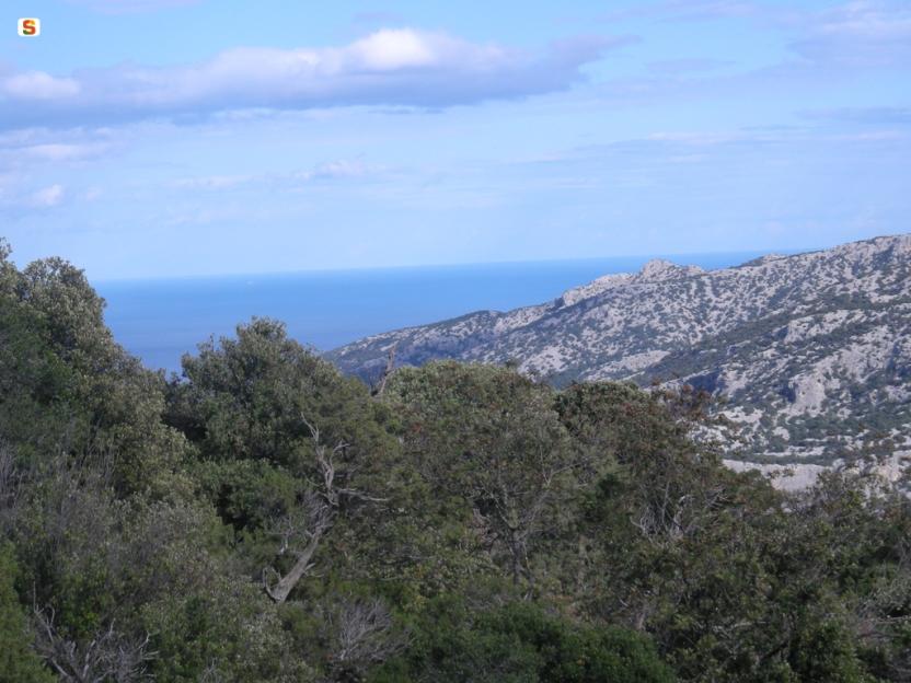
The mountain overlooking the village of Ollolai, once one of the most important centres in the area, is dedicated to San Basilio Magno, and the small road leads to the church dedicated to the saint, built in Byzantine era and then renovated several times, in front of which, are the ruins of the convent that once belonged to the Franciscans, and is the theatre of many legends. Just below the church and a spring, often dry in the hottest summers, there is a vast clearing surrounded by a dense Holm oak forest and an impressive series of granite peaks which are incredibly broken and varied. On the left, at the top of Sa Punta Manna, which you could reach via a route marked with some ropes, however it requires experience of short climbs along a path, to be tackled only if you are an experienced mountaineer and the rocks are dry.
The sign of history
The area of San Basilio was, however, inhabited in much earlier times than the church and convent can testify. The numerous caverns carved out by erosion in the granite tafoni have been inhabited, with certainty, since the Neolithic period, as many archaeological investigations testify. Hollowed-out rock shelters are scattered throughout the area, and to get an idea of the territory in which the proto-Sardinians operated, it is worth spotting, just below the small church, a fence that one meets on the right, towards the direction of the field. Beyond it, you come to a fairly obvious little path that begins to climb steeply in the middle of the wood, marked by the passage of people and bicycles, but with no trail signs or markings. You then reach a wide ridge in the middle of the forest where you come across a more visible track, the remains of a disused dirt road. Take it to the right, soon arriving near the communication mast that towers above the area. There are numerous sites of archaeological interest in the vicinity, although they are poorly signposted. After a visit to the scenic rocks near the antenna, you take the dirt road to the right, going downhill and soon returning to the tarmac road that leads back to the village.
Tipologia itinerario
- Log in to post comments
Photogallery
Ollolai, San Basilio. Un regno di granito
Accesso
Il Parco di San Basilio è ben indicato e dal centro abitato di Ollolai si prende una comoda strada asfaltata in salita, molto panoramica, che si lascia il paese alle spalle tuffandosi ben presto in un bosco di leccio. Dall’asfalto si passa al cemento, sfiorando in breve l’osservatorio astronomico di San Basilio, il Planetario di Ollolai, posto sulla destra della strada.
Si prosegue ancora per un breve tratto con scarse pendenze fino ad arrivare ad un ampio slargo dopo il quale la rotabile comincia a scendere con stretti tornanti.
San Basilio
Il monte che sovrasta il paese di Ollolai, un tempo uno dei centri più importanti della zona, è dedicato a San Basilio Magno e la stradina conduce proprio alla chiesa dedicata al Santo, edificata in epoca bizantina e poi ristrutturata più volte, davanti alla quale si trovano i ruderi del convento che fu dei francescani, teatro di molte leggende.
Poco sotto la chiesa e una sorgente, spesso in secca nelle estati più calde, si trova una vasta radura circondata da una fitta lecceta e da una impressionante serie di cime granitiche incredibilmente rotte e variegate. Sulla sinistra la cima di Sa Punta Manna sarebbe raggiungibile tramite un percorso segnato con alcune corde, ma richiede esperienza di brevi arrampicate lungo un percorso dal sapore alpinistico, da affrontare solo se si è esperti e con roccia asciutta.
Il segno della Storia
L’area di San Basilio era però frequentata in tempi assai più remoti di quelli che chiesa e convento possono testimoniare. I numerosissimi antri ricavati dall’erosione nei tafoni granitici sono stati abitati con certezza fin dal neolitico, come testimoniano molte ricerche archeologiche. I ripari sotto roccia scavati sono disseminati nell’area e per avere un’idea del territorio in cui si muovevano i protosardi è opportuno individuare, poco sotto la chiesina, una staccionata che si incontra sulla destra in direzione del campo.
Superatala, si incontra un sentierino abbastanza evidente che prende a salire deciso in mezzo al bosco, segnato dal passaggio delle persone e delle biciclette, ma privo di segnavia. Si raggiunge così un largo crinale in mezzo al bosco dove si incontra una traccia più marcata, quanto resta di una sterrata disastrata. La si prende sulla destra, giungendo in breve nei pressi del ripetitore che sovrasta la zona. Nei dintorni si trovano numerosi siti di interesse archeologico, anche se mal segnalati.
Dopo una visita alle panoramiche rocce nei pressi dell’antenna si prende la strada bianca sulla destra, perdendo quota e ritornando in breve alla strada asfaltata che ritorna al paese
Tipologia itinerario
- Log in to post comments
Photogallery
Oniferi, Sas Concas. The Necropolis
Access
The two archaeological sites visited by this simple tour can both be reached via the SS 128 road, directly from the village of Oniferi and following the signs for the SS 131. Leaving the last houses behind, you travel about 3.3 km and spot a tourist sign on the left indicating the necropolis. You will then park in a narrow space next to the main road.
Sas Concas
You pass a rudimentary wooden gate and descend along a gentle slope between some beautiful cork trees, passing a barely noticeable ford. On the left, a ridge of pyroclastites are clearly distinguishable, with a beautiful pinkish colour. The entire ridge is colonised by beautiful prickly pear plants, in sharp contrast to the orange lichens tenaciously attached to the rock: on these south-east-facing rocks the Neolithic inhabitants decided to find the final resting place for their loved ones, excavating one of the most extraordinary necropolises of their time. Wandering around the area, one can count up to twenty different tombs, often divided into several rooms. The domus de janas necropolis is also famous for the richness of the decorative elements in the burial chambers: ritual hearths, architectural elements relief carved and, above all, the mysterious graffiti symbolising stylised and upside-down men. The petroglyphs of Sas Concas are very similar to other depictions scattered in contemporary sites in Sardinia and represent an archaic and still mysterious symbolism: among the tombs of the necropolis, the best preserved ones are to be found in the large tomb of the hemicycle, preceded by a chamber excavated in the rock that is now largely eroded.
Nuraghe Ola
Once the visit to the necropolis is over, you can return to the car by continuing on the SS128, ignoring the detours for the SS 131 DCN and remaining on the old state road for about 3 km: on the left of the road, well signposted and visible, stands the magnificent Nuraghe Ola, at the centre of an area with a high density of archaeological monuments. The ancient nuragic tower, of a simple construction, can be reached by a short path from the car park. Immediately before the monument are two large huts, which have been the subject of archaeological investigation in recent times. The nuraghe was also recently restored. It consists of a large inner tholos chamber, where there are some alcoves, and a splendid intermural staircase that provides access to the upper floor. Here one notices a slab that closes the tholos and that, at the summer solstice, is sometimes removed to allow one to witness the suggestive phenomenon of the sun ray penetrating the darkness of the chamber below at midday. At the end of the visit, you can return to the village or visit the beautiful necropolis of Brodu, not far away, however its not signposted.
Tipologia itinerario
- Log in to post comments
Photogallery
Oniferi, Sas Concas. La necropoli
Accesso
I due siti archeologici visitati da questo semplice itinerario si raggiungono entrambi tramite la SS 128, direttamente dal paese di Oniferi e seguendo le indicazioni per la SS 131.
Lasciate le ultime case alle spalle si percorrono circa 3,3 km e si individua sulla sinistra un cartello turistico che indica la necropoli. Si posteggia così in un angusto spazio accanto alla statale.
Sas Concas
Si supera un rudimentale cancello fatto di legno e si scende un lieve declivio tra alcune belle sughere, superando un guado appena accennato. Sulla sinistra si distingue chiaramente un costone di piroclastiti, dal bel colore rosaceo. L’intero costone è colonizzato da belle piante di fichidindia, in forte contrasto con i licheni arancioni tenacemente attaccati alla roccia: su queste rocce esposte a sudest gli abitanti del Neolitico decisero di trovare l’estrema dimora per i propri cari, scavando una delle necropoli più straordinarie dei loro tempi.
Girovagando per la zona si possono contare fino a venti tombe diverse, articolate spesso al loro interno in più vani. La necropoli a domus de janas è celebre inoltre per la ricchezza degli elementi decorativi nei vani funerari: si individuano focolari rituali, elementi architettonici scolpiti in rilievo e soprattutto i misteriosi graffiti che simboleggiano uomini stilizzati e capovolti. I petroglifi di Sas Concas sono assai simili ad altre raffigurazioni sparse in siti coevi in Sardegna e rappresentano una simbologia arcaica e ancora misteriosa: tra le tombe della necropoli, quelli meglio conservati si trovano nell’ampia tomba dell’emiciclo, preceduta da un vano scavato nella roccia oggi in gran parte eroso.
Nuraghe Ola
Terminata la visita alla necropoli si può tornare all’auto proseguendo sulla SS128, ignorando le deviazioni per la SS 131 DCN e rimanendo sulla vecchia statale per circa 3 km: sulla sinistra della strada, ben segnalato e visibile, si staglia il magnifico Nuraghe Ola, al centro di un’area ad alta densità di monumenti archeologici.
L’antica torre nuragica, di tipo semplice, si raggiunge per un breve sentiero che si diparte dal parcheggio. Subito prima del monumento si incontrano due ampie capanne, oggetto di indagine archeologica in tempi recenti. Anche il nuraghe è stato recentemente restaurato. Si compone di un’ampia camera interna a tholos, dove sono presenti alcune nicchie, e da una splendida scala intermuraria che permette di accedere al piano superiore. Qui si nota una lastra che chiude la tholos e che, nel solstizio d’estate, viene talvolta rimossa per permettere di assistere al suggestivo fenomeno del raggio di sole che, a mezzogiorno, penetra nel buio della camera sottostante.
Terminata la visita si può rientrare al paese o visitare la bella necropoli di Brodu, poco distante, ma non segnalata
Tipologia itinerario
- Log in to post comments
Photogallery
Sentiero Italia (Stage Z16) Sa Senipida - Ilodei Malu (Caserma Montes)
Overview of the itinerary
Sentiero Italia runs the length of the island’s eastern side, covering its most important mountains, in 28 stages. Starting from the north: it flanks the Monte Limbara massif, crosses the limestones of Mont’Albo and Tuttavista, skirting the Gulf of Orosei, it crosses the Supramonte, Gennargentu and the Tacchi of Ogliastra and reaches Perdasdefogu. Further south, it passes through Armungia and the Gerrei sub-region. Lastly, it touches on the villages of Burcei and San Gregorio, continuing on the Sette Fratelli massif to the old prisons of Castiadas.
General information on Sentiero Italia (Grand Italian Trail)
Sentiero Italia, or Grand Italian Trail, as also explained on the official website, is a walking route that crosses the whole of Italy, using mainly but not exclusively “registered trails”.
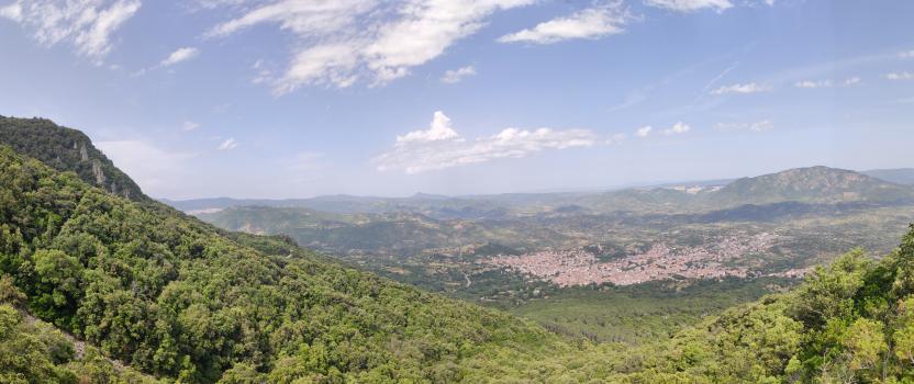
In particular, in Sardinia, not all the stages of the Sentiero Italia of CAI (Italian Alpine Club) are made of trails already included in the registry of the Sardinia Trail Network (RES), either because they have not yet been tested and approved or simply because they cannot be registered as they do not meet the requirements. However, as a whole, the Sentiero Italia is the single longest walking route currently crossing Sardinia from the north (S. Teresa Gallura, stage Z 1) to the south (Castiadas, end of stage Z 28), touching on the most fascinating mountain areas in central-eastern Sardinia: the plateau of Buddusò, Tepilora, the Cedrino river valley, the ancient forests of Montes, Perda Liana and the regional forest of Montarbu, Monte Genis, and lastly the regional forest of Settefratelli (among the many crossed by the various stages of this long hiking itinerary).
Information on this stage of the trail
The planned stop point at the cuile Sa Sinipida can currently be used as a camping point, with a spring nearby. For support, please contact Efisio Manca, mobile 3202745951.
The route begins with an easy dirt track that leads to the crossing of the Badde Tureddu stream and then winds uphill passing a spring. At 987 m asl, trail 441 leaves the dirt track and enters the forest. A beautiful trail through a forest of holm oaks and cork trees with route markings on trees and stone cairns. Once past the forest, continue along the trail that becomes a dirt track just before the camping point of ziu Mulittu (two fairly comfortable stone huts).
At the 441-441C fork, continue north-west on 441 towards the ruins of the cuile (sheepfold) of Sos Pisanos and then go up towards Monte Novo San Giovanni where a fire lookout overlooks a vast unspoilt territory. After leaving Monte Novo, continue south-west towards Monte Fumai, at 1316 m asl, and then head north towards the forest ranger station of Montes (Ilodei Malu).
Informazioni utili
Tipologia itinerario
- Log in to post comments
Photogallery
Sentiero Italia (Tappa Z16) Sa Senipida - Ilodei Malu (Caserma Montes)
In sintesi
Il Sentiero Italia attraversa in lunghezza il settore orientale dell’isola toccandone i sistemi montuosi più rilevanti, in 28 tappe. Partendo da nord: tocca il massiccio del Monte Limbara, attraversa i calcari del Mont'Albo e del Tuttavista sfiorando il Golfo di Orosei, attraversa il Supramonte, il Gennargentu, i Tacchi dell’Ogliastra e giunge a Perdasdefogu. Più a sud, transita da Armungia e dalla subregione del Gerrei. Infine tocca l’abitato di Burcei e San Gregorio, per continuare nel massiccio dei Sette Fratelli fino alle vecchie carceri di Castiadas.
Informazioni generali sull'itinerario sentiero Italia
Il Sentiero Italia, come spiegato anche nel sito ufficiale, è un itinerario (o Cammino) lungo tutta l'Italia, che utilizza prevalentemente ma non esclusivamente "sentieri accatastati".
In particolare, in Sardegna, non tutte le tappe del Sentiero Italia del CAI coincidono con sentieri già inseriti nel catasto della Rete Escursionistica della Sardegna (RES), perché non hanno ancora superato le verifiche di percorribilità oppure semplicemente perché non possono essere accatastati non avendone i requisiti. Tuttavia, nel suo insieme, il Sentiero Italia rappresenta l'unica, la più grande dorsale escursionistica che attraversa attualmente la nostra Isola da nord (S. Teresa Gallura, tappa Z 1) a sud (Castiadas, fine tappa Z 28) toccando le aree montane della Sardegna centro-Orientale più affascinanti: l'altopiano di Buddusò, Tepilora, la valle del Cedrino, i boschi vetusti di Montes, Perda Liana e la foresta demaniale di Montarbu, il Monte Genis, e infine la foresta demaniale di Settefratelli (tra le tante attraversate dal lungo itinerario escursionistico a tappe).
Info sul percorso di questa tappa
Il posto tappa previsto al cuile Sa Sinipida è attualmente utilizzabile come bivacco con presenza di sorgente nei pressi. Per assistenza è necessario contattare Efisio Manca, cell. 3202745951.
Il percorso inizia con una agevole sterrata che porta ad attraversare il rio Badde Tureddu per poi risalire con una serie di tornanti lungo i quali si trova una sorgente. Arrivati a quota 987 slm il sentiero 441 lascia la sterrata ed entra nel bosco. Un bel sentiero in mezzo ad un bosco di lecci e sughere segnalato da segnavia su alberi e da omini in pietra. Superato il bosco si continua sul sentiero che diventa sterrata poco prima dei bivacchi di ziu Mulittu (due costruzioni in pietra abbastanza confortevoli).
Arrivati al bivio 441-441C si continua sul 441 in direzione nord-ovest verso le rovine del cuile Sos Pisanos per poi risalire verso Monte Novo San Giovanni dove è presente una vedetta antincendio che domina un vasto territorio incontaminato. Lasciato Monte Novo si prosegue in direzione sud-ovest verso Monte Fumai , 1316 slm, per poi proseguire in direzione nord verso la caserma forestale di Montes (Ilodei Malu).
Informazioni utili
Lungo il percorso non sarà sempre presente la copertura telefonica
Tipologia itinerario
- Log in to post comments
Photogallery
Contiene carte
Spento