Start website main content

For shoes full of steps! Not just "Sentiero Italia" with its 28 stages along the authentic eastern ridge: many other routes to explore the wildest - and therefore most evocative - places of the island. Routes identifiable in the signs of the official routes of the RES Cadastre, standardized by trail arrows and white-red flags. They cross the most spectacular scenery: Supramonte, Ogliastra dei Tacchi, Bosa-Villanova-Alghero coast, Nurra, Argentiera, Limbara, Montalbo, Settefratelli, Linas-Marganai, Gutturu Mannu...
Arm yourself with energy, courage and the desire to discover, but accompanied by expert people or guides!

Itinerari

Sentiero Italia (Stage Z09) Caserma Forestale Gianni Stuppa – Vecchia Cantoniera di Sant’Anna

Overview of the itinerary

Sentiero Italia runs the length of the island’s eastern side, covering its most important mountains, in 28 stages.  Starting from the north: it flanks the Monte Limbara massif, crosses the limestones of Mont’Albo and Tuttavista, skirting the Gulf of Orosei, it crosses the Supramonte, Gennargentu and the Tacchi of Ogliastra and reaches Perdasdefogu.  Further south, it passes through Armungia and the Gerrei sub-region. Lastly, it touches on the villages of Burcei and San Gregorio, continuing on the Sette Fratelli massif to the old prisons of Castiadas.

General information on Sentiero Italia (Grand Italian Trail)

Sentiero Italia, or Grand Italian Trail, as also explained on the official website, is a walking route that crosses the whole of Italy, using mainly but not exclusively “registered trails”.   
In particular, in Sardinia, not all the stages of the Sentiero Italia of CAI (Italian Alpine Club) are made of trails already included in the registry of the Sardinia Trail Network (RES), either because they have not yet been tested and approved or simply because they cannot be registered as they do not meet the requirements.  However, as a whole, the Sentiero Italia is the single longest walking route currently crossing Sardinia from the north (S. Teresa Gallura, stage Z 1) to the south (Castiadas, end of stage Z 28), touching on the most fascinating mountain areas in central-eastern Sardinia: the plateau of Buddusò, Tepilora, the Cedrino river valley, the ancient forests of Montes, Perda Liana and the regional forest of Montarbu, Monte Genis, and lastly the regional forest of Settefratelli (among the many crossed by the various stages of this long hiking itinerary).

Information on this stage of the trail

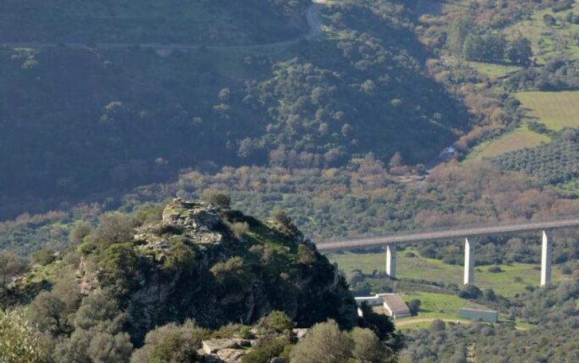
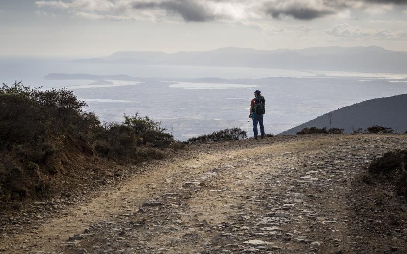
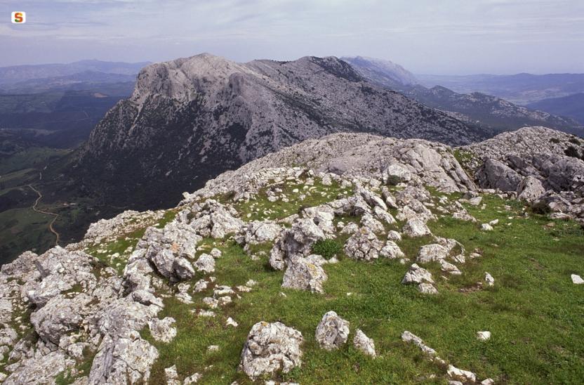
Athis fairly long leg of the trail crosses the Tepilora Park, starting on an easy dirt road leading to the slopes of Mount Tepilora, where it continues on paths and old mule tracks until it fords Rio Mannu. The trail then begins to climb fairly steeply, including a few stretches of blacktop road, reaching the highest part of the route, with an east-northeast direction and wide-ranging views of the countryside round PosadaMaccheronis Lake and the sea in the distance. 

The route continues on a short stretch of provincial road, then on recently restored paths and stretches of forest track until it reaches S. Anna di Lodè, with elevations varying between 400 and 625 m asl. 

This route offers expansive views and frequent freshwater springs, sparing hikers from having to carry a heavy load of water.

Notes

Note of 30/08/2021. At the Juanne Stuppa forest ranger station, it is currently only possible to stay pitching a tent. Along the trail, there is also a natural stop point suitable for pitching a tent. At the end of this leg of the trail, in the S. Anna di Lodè locality there are a few B&Bs.

Lenght 26.200 m

SI Z09.gpx

Total elevation gain 1 678 metri

Geographical area Baronie e Montalbo

Sentiero Italia (Stage Z08) Alà dei Sardi – Caserma Giuanne Stuppa

Overview of the itinerary

Sentiero Italia runs the length of the island’s eastern side, covering its most important mountains, in 28 stages.  Starting from the north: it flanks the Monte Limbara massif, crosses the limestones of Mont’Albo and Tuttavista, skirting the Gulf of Orosei, it crosses the Supramonte, Gennargentu and the Tacchi of Ogliastra and reaches Perdasdefogu.  Further south, it passes through Armungia and the Gerrei sub-region. Lastly, it touches on the villages of Burcei and San Gregorio, continuing on the Sette Fratelli massif to the old prisons of Castiadas.

General information on Sentiero Italia (Grand Italian Trail)

Sentiero Italia, or Grand Italian Trail, as also explained on the official website, is a walking route that crosses the whole of Italy, using mainly but not exclusively “registered trails”.   
In particular, in Sardinia, not all the stages of the Sentiero Italia of CAI (Italian Alpine Club) are made of trails already included in the registry of the Sardinia Trail Network (RES), either because they have not yet been tested and approved or simply because they cannot be registered as they do not meet the requirements.  However, as a whole, the Sentiero Italia is the single longest walking route currently crossing Sardinia from the north (S. Teresa Gallura, stage Z 1) to the south (Castiadas, end of stage Z 28), touching on the most fascinating mountain areas in central-eastern Sardinia: the plateau of Buddusò, Tepilora, the Cedrino river valley, the ancient forests of Montes, Perda Liana and the regional forest of Montarbu, Monte Genis, and lastly the regional forest of Settefratelli (among the many crossed by the various stages of this long hiking itinerary).

Information on this stage of the trail

The last leg in the territory of Sassari leads to the nuraghe Boddò , strategically located on an imposing granite hill within sight of several other nuraghi in the surrounding area. 

You will then cross the valley of Rio Altana with beautiful pools of clear water to be admired while searching for the river crossing point. 

After passing through part of the Tepilora Regional Park, you will reach the Giuanne Stuppa forest ranger station where you can stay overnight.

Notes

The ford across the rio Altana can be challenging (it may be impassable in the winter months). At the Giuanne Stuppa stop point there is a Fo.Re.S.T.A.S. station, where it is currently only possible to stay overnight pitching a tent.

Lenght 20.500 m

SI Z08.gpx

Total elevation gain 601 metri

Geographical area Monteacuto

Sentiero Italia (Stage Z07) Caserma Forestale Bolostiu – Alà dei Sardi

Overview of the itinerary

Sentiero Italia runs the length of the island’s eastern side, covering its most important mountains, in 28 stages.  Starting from the north: it flanks the Monte Limbara massif, crosses the limestones of Mont’Albo and Tuttavista, skirting the Gulf of Orosei, it crosses the Supramonte, Gennargentu and the Tacchi of Ogliastra and reaches Perdasdefogu.  Further south, it passes through Armungia and the Gerrei sub-region. Lastly, it touches on the villages of Burcei and San Gregorio, continuing on the Sette Fratelli massif to the old prisons of Castiadas.

General information on Sentiero Italia (Grand Italian Trail)

Sentiero Italia, or Grand Italian Trail, as also explained on the official website, is a walking route that crosses the whole of Italy, using mainly but not exclusively “registered trails”.   
In particular, in Sardinia, not all the stages of the Sentiero Italia of CAI (Italian Alpine Club) are made of trails already included in the registry of the Sardinia Trail Network (RES), either because they have not yet been tested and approved or simply because they cannot be registered as they do not meet the requirements.  However, as a whole, the Sentiero Italia is the single longest walking route currently crossing Sardinia from the north (S. Teresa Gallura, stage Z 1) to the south (Castiadas, end of stage Z 28), touching on the most fascinating mountain areas in central-eastern Sardinia: the plateau of Buddusò, Tepilora, the Cedrino river valley, the ancient forests of Montes, Perda Liana and the regional forest of Montarbu, Monte Genis, and lastly the regional forest of Settefratelli (among the many crossed by the various stages of this long hiking itinerary).

Information on this stage of the trail

This leg of the trail is particularly fascinating because of the many places of interest along the way. The first is the charming hamlet of Badde Suelzu consisting of a dozen houses and... as many inhabitants. The prehistoric Sanctuary of Sos Nurattolos is next, with the ruins of stone huts, a sacred spring, and a megaron-type temple

After walking past a few wind turbines and a mountain shrine to the Madonna della Neve (Our Lady of the Snows), you will reach Alà dei Sardi. Just before the village, it is worth making a small detour to visit the megalithic wall of Sos Alchibusos, on the granite hill of Sa Torolia.

Lenght 18.000 m

SI Z07.gpx

Total elevation gain 765 metri

Geographical area Monteacuto

Sentiero Italia (Stage Z06) Monti – Caserma Forestale Bolostiu

Overview of the itinerary

Sentiero Italia runs the length of the island’s eastern side, covering its most important mountains, in 28 stages.  Starting from the north: it flanks the Monte Limbara massif, crosses the limestones of Mont’Albo and Tuttavista, skirting the Gulf of Orosei, it crosses the Supramonte, Gennargentu and the Tacchi of Ogliastra and reaches Perdasdefogu.  Further south, it passes through Armungia and the Gerrei sub-region. Lastly, it touches on the villages of Burcei and San Gregorio, continuing on the Sette Fratelli massif to the old prisons of Castiadas.

General information on Sentiero Italia (Grand Italian Trail)

Sentiero Italia, or Grand Italian Trail, as also explained on the official website, is a walking route that crosses the whole of Italy, using mainly but not exclusively “registered trails”.   
In particular, in Sardinia, not all the stages of the Sentiero Italia of CAI (Italian Alpine Club) are made of trails already included in the registry of the Sardinia Trail Network (RES), either because they have not yet been tested and approved or simply because they cannot be registered as they do not meet the requirements.  However, as a whole, the Sentiero Italia is the single longest walking route currently crossing Sardinia from the north (S. Teresa Gallura, stage Z 1) to the south (Castiadas, end of stage Z 28), touching on the most fascinating mountain areas in central-eastern Sardinia: the plateau of Buddusò, Tepilora, the Cedrino river valley, the ancient forests of Montes, Perda Liana and the regional forest of Montarbu, Monte Genis, and lastly the regional forest of Settefratelli (among the many crossed by the various stages of this long hiking itinerary).

Information on this stage of the trail

The starting point is the village of Monti, near the Vermentino winery. After walking a little less than 2 km on a blacktop road, used by local traffic, a 2.3 km stretch on a livestock trail begins. From here the route is on a path, for about 1 km, to the Sos Sambinzos locality (in this stretch there are two fords on the rio Crasta), from where the trail will take you back to a livestock trail that will lead you, through private land (with stiles to pass over the boundary wall) to the Monte Olia regional forest. The forest is crossed by several tracks, which are used by the Forest Rangers also for wildfire control. In this stretch, you can deviate slightly from the route to stop at the ‘Pedra Bianca’ spring and the nearby hut, fairly comfortable and freely accessible, used by the staff of Fo.Re.S.T.A.S. 

After retracing your steps back from the spring, to the main trail, continue on a dirt road towards the ford on the Seleme river.  Along its course, the river forms beautiful natural pools known as ‘Salomone’, some of which are near the ford. 

After crossing the river, the route climbs up a trail that follows a firebreak, and then continues on a dirt road to the ‘Bolostiu’ forest ranger station. If the Seleme river is impassable, you must head, within the regional forest, towards the forest ranger station of Monte Olia, bordering road SS 389, which connects Monti with Alà dei Sardi, and return to the path from the blacktop road heading to the village of Badde Suelzu.

Notes

The ford across the Seleme river can be challenging (it may be impassable in the winter months but you can take an alternative route via SS 389). 

At the Bolostiu stop point there is a station of the Fo.Re.S.T.A.S. Regional Agency.. At present, accommodation is not available but hikers can pitch their tent.

Lenght 15.600 m

SI Z06.gpx

Total elevation gain 818 metri

Geographical area Gallura

Sentiero Italia (Stage Z05) Calangianus – Monti

Overview of the itinerary

Sentiero Italia runs the length of the island’s eastern side, covering its most important mountains, in 28 stages.  Starting from the north: it flanks the Monte Limbara massif, crosses the limestones of Mont’Albo and Tuttavista, skirting the Gulf of Orosei, it crosses the Supramonte, Gennargentu and the Tacchi of Ogliastra and reaches Perdasdefogu.  Further south, it passes through Armungia and the Gerrei sub-region. Lastly, it touches on the villages of Burcei and San Gregorio, continuing on the Sette Fratelli massif to the old prisons of Castiadas.

General information on Sentiero Italia (Grand Italian Trail)

Sentiero Italia, or Grand Italian Trail, as also explained on the official website, is a walking route that crosses the whole of Italy, using mainly but not exclusively “registered trails”.   
In particular, in Sardinia, not all the stages of the Sentiero Italia of CAI (Italian Alpine Club) are made of trails already included in the registry of the Sardinia Trail Network (RES), either because they have not yet been tested and approved or simply because they cannot be registered as they do not meet the requirements.  However, as a whole, the Sentiero Italia is the single longest walking route currently crossing Sardinia from the north (S. Teresa Gallura, stage Z 1) to the south (Castiadas, end of stage Z 28), touching on the most fascinating mountain areas in central-eastern Sardinia: the plateau of Buddusò, Tepilora, the Cedrino river valley, the ancient forests of Montes, Perda Liana and the regional forest of Montarbu, Monte Genis, and lastly the regional forest of Settefratelli (among the many crossed by the various stages of this long hiking itinerary).

Information on this stage of the trail

After a stop at the interesting Museo del Sughero (Cork Museum), leave the town of Calangianus to visit the tomb of the giants (megalithic communal tomb) of ‘Pascaredda’. This is a beautiful, well-maintained site that is easily reached as it is well-signposted. 

Retrace your steps for about 500 m and return to the path to see the church of ‘Le Grazie’. The church, built in granite stone, can be visited through the side door, which is open. Inside, it has a beautiful altar. 

After this stop, continue on your way towards Monte Limbara. Before taking the dirt road leading to the top of the mountain at 1025 m asl, you will cross the cycle path built on the former Calangianus-Monti railway line. The crossing point with the cycling path is fully signposted. Worthy of note at li Conchi is the presence of valuable tafoni (rock cavities), which have been used as natural shelters since ancient times.

If you wish to avoid the climb up Monte Limbara, you can follow the cycle path that leads in the direction of the Monti railway station. On Monte Limbara, at the Li Conchi locality, there are two wooden huts, the first privately owned (hunting company), the second owned by the municipality of Calangianus and managed by the Fo.Re.S.T.A.S. Regional Agency. This hut can be used, upon request, as an intermediate stop point, since the trail stage from Calangianus to Monti is 37.80 km long. 

There are also two fountains, one along the route at the Li Conchi locality and the other, the Crispoli fountain, which can be reached by a diversion of just over 1 km. The area is very beautiful and is dotted with caves. 

After a short stretch, still on a dirt road, you must turn left in a south-southeasterly direction, in the direction of Monti, passing alongside Punta Cupuneddi. From this fork towards Vallicciola (a charming locality with some sequoia trees), if you intend to stay for one or two days, you can walk the paths of Monte Limbara for more than 60 km. 

After reaching the locality of Piandiscopa (indicated by an old signpost), continue along a livestock trail and then, after walking on a recently created path, follow a downhill livestock trail for more than 700 m ending near the ‘lu rustu stazzo (farmhouse). After crossing the stazzo or, alternatively, after following the cycling path, pass the provincial road (SP) that turns right to Berchidda and left to Calangianus, continue on a dirt road that after a few kms, just before the former Sa Corona agritourism farm, becomes a tarmac road. After crossing, via underpasses, the railway tracks and the state road (SS), you will reach Monti.

Notes

Fairly long stage, about 38 km. An intermediate overnight camp is planned on Monte Limbara in the Li Conchi locality, where however, the accommodation facility is not currently available.

Lenght 34.800 m

SI Z05.gpx

Total elevation gain 1 130 metri

Geographical area Gallura