Accessible trails
Sentieri per tutti...in questa categoria rientrano i sentieri progettati o riadattati perchè il contatto con l'ambiente naturale sia sempre di stimolo al miglioramento della vita personale di chiunque, con attenzione alle condizioni di disabilità motoria, sensoriale o della sfera psichica e relazionale...

Image credits Sardegna Digital Library Regione Sardegna
Results
Pathways Funtana Cungiada (T-781)
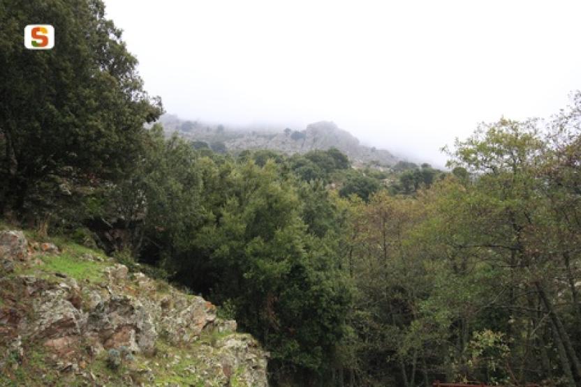
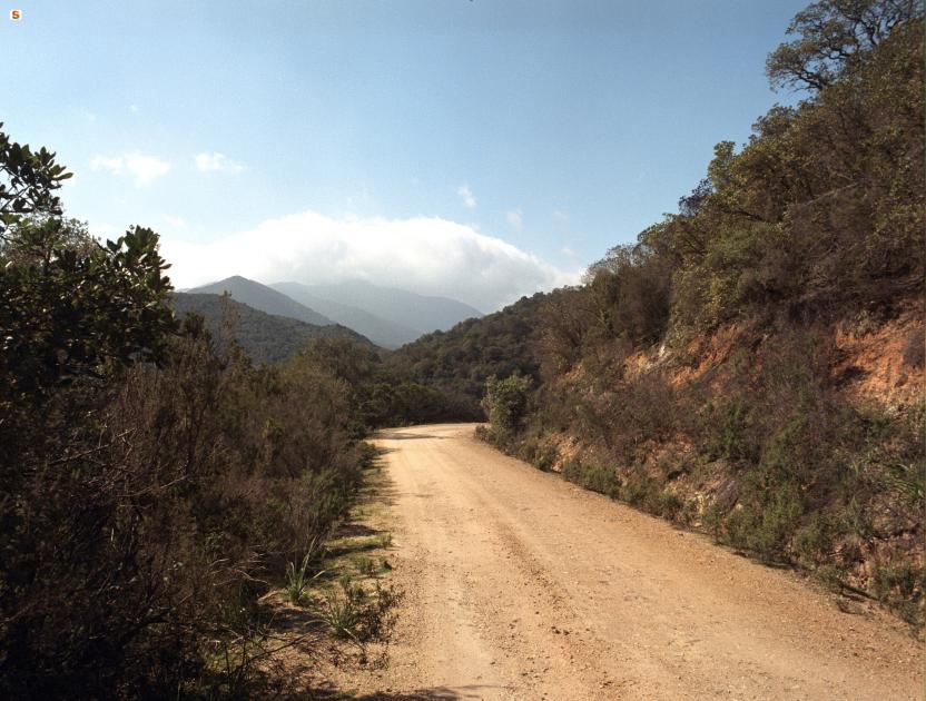
CMSB - STAGE 07 – FROM MONTEVECCHIO TO ARBUS
Through the ancient path of the miners, you will descend from the metalliferous hills of the Guspinese-Arburese area down to the Campidano plain, where you will see basalt flows deriving from Tertiary volcanism thanks to the spectacular geological site of the basalt columns, and then climb the hill by walking on granite rocks to reach the town of Arbus.
The typical landscape of agricultural and livestock activities. Then you enter the Linas mountain range with its large forests and rich variety of mineral deposits.
Safety and useful tips
The downhill from Montevecchio involves crossing the SP04 road from Montevecchio towards Guspini several times. Watch out for crossings of the asphalted road, which often occur near curves and hairpin turns.
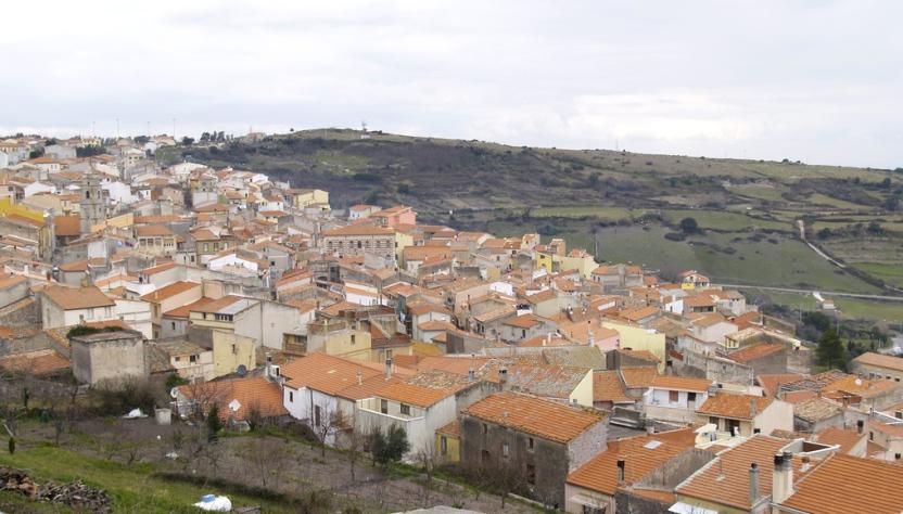
Once in Guspini, you have to follow an urban route, therefore pay attention to the urban traffic.
You will finally arrive in Arbus and once again you have to follow an urban route, so watch out for vehicular traffic.
During the downhill from Montevecchio, and also in the small village itself, you will come across several disused buildings and mining structures in an obvious state of disrepair, with the exception of those for which a passageway or a specially guided tour has been created. Avoid crossing the fences and/or venturing inside them, but always admire them from a distance without leaving the Trail.
Informazioni utili
The stage presents a medium difficulty. The route is 16 km long and can be covered in 5 hours and has a height difference of 541 m uphill and 609 m downhill.
FOR UPDATED INFORMATION, CONSULT THE STAGE SHEET ON THE OFFICIAL WEBSITE
Tipologia itinerario
- Log in to post comments
Links
Photogallery
CMSB - TAPPA 7: DA MONTEVECCHIO AD ARBUS
Attraverso l’antico sentiero dei minatori si scende dalle colline metallifere del Guspinese-Arburese verso la pianura del Campidano per poi risalire in collina camminando su rocce granitiche fino al centro abitato di Arbus. Il percorso offre la vista di colate basaltiche del vulcanismo terziario con lo spettacolare geo-sito dei basalti colonnari.
Il paesaggio che si incontra in questa tappa è quello tipico delle aree con un'alta concentrazione di attività agricole e zootecniche. Inoltre si entra nel complesso montuoso del Linas, con le sue grandi foreste e una ricca varietà di giacimenti minerari.
Informazioni utili
La tappa presenta una difficoltà media. Il percorso ha una lunghezza di 16 km percorribili in 5 ore e un dislivello in salita di 541 m e in discesa di 609 m.
PER LE INFORMAZIONI AGGIORNATE, CONSULTA LA SCHEDA DELLA TAPPA, SUL SITO UFFICIALE
Il Cammino Minerario di Santa Barbara
Si tratta del primo, tra i cammini sardi, ad essere stato iscritto al registro istituito dalla Regione Sarda nel 2012 con DGR48/9 ("Registro dei cammini di Sardegna, degli itinerari religiosi e dello spirito"). Attualmente è gestito dall'omonima Fondazione.
LA STORIA DEL PROGETTO
L’idea di costruire un itinerario nell’area più estesa e rappresentativa del Parco Geominerario Storico Ambientale della Sardegna, il Sulcis-Iglesiente-Guspinese, riscoprendo gli antichi cammini minerari oggi in gran parte abbandonati, è nata dai volontari dell’Associazione ONLUS Pozzo Sella Per il Parco Geominerario a seguito della grande partecipazione dei cittadini alle escursioni organizzate dalla stessa associazione dopo aver reso fruibili numerosi percorsi minerari.
Con il Cammino Minerario di Santa Barbara si vuole perseguire l’obiettivo di tramandare la memoria degli uomini che nei secoli e nei millenni passati hanno realizzato e percorso gli antichi cammini minerari con il piacere di riscoprire a passo lento la bellezza del territorio.
Un Protocollo d’intesa è stato sottoscritto tra i Comuni di Iglesias, Buggerru, Fluminimaggiore, Arbus, Guspini, Gonnosfanadiga, Villacidro, Domusnovas, Musei, Villamassargia. Narcao, Nuxis, Santadi, Piscinas, Giba, Masainas, San Giovanni Suergiu, Sant’Antioco, Carbonia e Gonnesa, le Diocesi di Iglesias e di Ales Terralba, le Province di Carbonia Iglesias e del Medio Campidano, il Consorzio del Parco Geominerario Storico Ambientale della Sardegna, l’ANCI SARDEGNA e l’Associazione Pozzo Sella: si tratta di un partenariato per la costruzione e la gestione dell’itinerario storico, culturale, ambientale e religioso denominato “Cammino Minerario di Santa Barbara”.
PER MAGGIORI INFORMAZIONI, DETTAGLI E INFO AGGIORNATE SULLE TAPPE
Si consiglia di consultare il sito ufficiale del cammino: www.camminominerariodisantabarbara.org/
Tipologia itinerario
- Log in to post comments
Links
Photogallery
Roadbook
Seguendo l’antico sentiero dei minatori - in un'area dominata dalle colate basaltiche del vulcanismo terziario che offrono lo spettacolare geo-sito dei basalti colonnari - si scende dalle colline metallifere del Guspinese-Arburese verso la pianura del Campidano.
Raggiunto il paese di Guspini si risale in collina camminando su rocce granitiche fino al centro abitato di Arbus lungo un percorso che offre il paesaggio tipico delle aree ricche di attività agricole e zootecniche.
Genna 'e Crecu - Sorgono
An itinerary of great naturalistic value that allows you to appreciate both the dense native woods, dominated by holm oaks and downy oaks, and the pine afforestation of the high-altitude part, in which they are perfectly integrated. The route is rather smooth and does not present any particular tech-nical difficulties. Among the attractions of the route, at an altitude of 920 m, is the country church of Sa Ìtria, one of the highest in the whole of Sardinia, and a small house with a fireplace available for hikers, in a splendid panoramic position, for which the rules always apply: keep clean, close well be-fore leaving and leave a good supply of wood, both fine and coarse, inside. In the last few kilometres there is also a railway tollgate, which provides an insight into the life and work of a tollman on moun-tain railway lines dating back to the end of the 19th century.
Informazioni utili
The LEADER Territory of the Local Action Group (GAL) Rural District Barbagia Mandrolisai Gennargentu (BMG)
Consisting of the Union of Municipalities of Barbagia and the Mountain Community of Gennargentu Mandrolisai. The GAL BMG, therefore, includes 19 municipalities, with a total area of 854.30 sq km and a resident population of approximately 22,000 inhabitants: Aritzo, Atzara, Austis, Belvì, Desulo, Gadoni, Gavoi, Lodine, Meana Sardo, Ollolai, Oniferi, Olzai, Ortueri, Ovodda, Sarule, Sorgono, Teti, Tiana, Tonara.
The GAL Rural District BMG, established in 2009, is a participation foundation composed of 22 public members and over 200 private members, representing the main institutional, economic, and social components of the territory. The foundation aims to improve the quality of life and well-being of communities in the historical regions of Barbagia, Mandrolisai, and Gennargentu by enhancing local resources. The main thematic and intervention areas identified by the GAL BMG for the definition of its Local Development Strategy 2014-2022 are the development and innovation of local production chains and systems, social inclusion, and sustainable tourism.
THE OAST PROJECT: OUTDOOR ACTIVITIES FOR SUSTAINABLE TOURISM
The project, coordinated by the GAL BMG in partnership with the GAL Sisteron-Buëch (France) and the GAL Kilkenny (Ireland), aims to promote sustainable and active tourism in rural areas of Europe. The specific objective of the project was to enhance and develop the tourist attractiveness of the inland waters of Barbagia, through outdoor sports and water activities, in line with the thematic area "sustainable tourism" chosen in the GAL BMG's PDA. The three territories involved boast a rich and varied natural, landscape, and cultural heritage with strong identity traits and enormous potential for the development of active tourism. However, some problems common to all partners have been highlighted, such as: insufficient enhancement and tourist promotion of inland areas, isolation, the absence of an international network useful for the exchange of good practices, and insufficient diversification, delocalization, deseasonalization, and internationalization of tourist flows. The OAST Project was created to respond to these critical issues, as active tourism and sustainable tourism represent the basis for the revival of territories characterized by enormous problems of depopulation, lack of services, unemployment, and school dropout. The idea, therefore, is to promote forms of sustainable, active, responsible, and experiential tourism, as well as to offer diversified and deseasonalized solutions suitable for a constantly growing number of active tourists. The specific action involved the georeferencing and description, in Italian and English, of 19 GAL BMG itineraries related to the theme of water. The itinerary tracks are available and downloadable, in Gpx format, on these pages and also on the GAL BMG's Wikiloc account.
Tipologia itinerario
- Log in to post comments
Photogallery
Contiene carte
Spento