Start website main content

Accessible trails

1 pathway

Sentieri per tutti...in questa categoria rientrano i sentieri progettati o riadattati perchè il contatto con l'ambiente naturale sia sempre di stimolo al miglioramento della vita personale di chiunque, con attenzione alle condizioni di disabilità motoria, sensoriale o della sfera psichica e relazionale...

Rio Ermolinos.jpg

Results

Sentiero Italia (Stage Z02) Saltàra - Luogosanto

Overview of the itinerary

Sentiero Italia runs the length of the island’s eastern side, covering its most important mountains, in 28 stages.  Starting from the north: it flanks the Monte Limbara massif, crosses the limestones of Mont’Albo and Tuttavista, skirting the Gulf of Orosei, it crosses the Supramonte, Gennargentu and the Tacchi of Ogliastra and reaches Perdasdefogu.  Further south, it passes through Armungia and the Gerrei sub-region. Lastly, it touches on the villages of Burcei and San Gregorio, continuing on the Sette Fratelli massif to the old prisons of Castiadas.

General information on Sentiero Italia (Grand Italian Trail)

Sentiero Italia, or Grand Italian Trail, as also explained on the official website, is a walking route that crosses the whole of Italy, using mainly but not exclusively “registered trails”.   
In particular, in Sardinia, not all the stages of the Sentiero Italia of CAI (Italian Alpine Club) are made of trails already included in the registry of the Sardinia Trail Network (RES), either because they have not yet been tested and approved or simply because they cannot be registered as they do not meet the requirements.  However, as a whole, the Sentiero Italia is the single longest walking route currently crossing Sardinia from the north (S. Teresa Gallura, stage Z 1) to the south (Castiadas, end of stage Z 28), touching on the most fascinating mountain areas in central-eastern Sardinia: the plateau of Buddusò, Tepilora, the Cedrino river valley, the ancient forests of Montes, Perda Liana and the regional forest of Montarbu, Monte Genis, and lastly the regional forest of Settefratelli (among the many crossed by the various stages of this long hiking itinerary).

Information on this stage of the trail

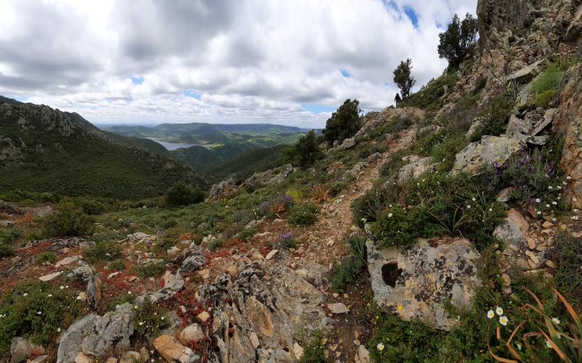
Leaving the small town of Luogosanto, the route follows a local blacktop road in the direction of the Fonte La Filetta Park. At a fork in the road, it leaves the road leading to La Filetta Park and follows the road to the right in a south-westerly direction until it reaches the stile at the entrance to the stazzo (farmhouse) of Sesara. The route continues on a dirt track through private land, crossing gates that can be opened and then must be closed again. The route continues through the beautiful landscapes characteristic of Gallura, with granite rock outcrops, holm oaks and wild olive trees, until it reaches the small country church of San Biagio.
In Gallura there are many country churches around which, on feast days, lunches are organised for hundreds or even thousands of people.

Leaving the church of San Biagio, the route heads in the direction of the ford across the Liscia river. 

PLEASE NOTE: this section of the trail is not marked as the landowner has not authorised the installation of signs. Once past the river, the route climbs up a path flanking a cliff and through a young forest of predominantly holm oaks and strawberry trees. At one time, this forest consisted of primary trees that were cut down for charcoal in the 19th century. Short sections of the path built at that time have been restored. 

After leaving the trail, the route continues along a local road that runs alongside the Liscia lake. It continues on a livestock trail, on private property. On this stretch, you can admire an over 2000-year-old wild olive tree and the viaduct of a railway line now only used in the summer months as a tourist line. The trail arrives in Sant'Antonio di Gallura after following a stretch of blacktop road and, if you wish, after a detour to the railway station near Lake Liscia. Sant’Antonio is ‘heir’ to an ancient medieval village, Villa de Castro, built at the foot of the Lu Naracu nuraghe (prehistoric stone fortress) a few hundred metres from the ancient church of S. Andrea and from the current square in the centre of the village. The church of Sant’Andrea, which was built no later than the 1700s, belonged to the noble Pes family of Tempio Pausania.

Approximately 5 km from Sant’Antonio di Gallura, deviating on a farm road, is the farmhouse of Ms Santoli, who has preserved the original furnishings and collected photographs and interesting pieces of rural art over the years. In the immediate vicinity of the village are thousand-year-old wild olive trees. The area is also rich in archaeological heritage, including the Sarra di l'Aglientu megalithic wall near the Liscia lake. The countryside of Gallura is dotted with small country churches that, on feast days, celebrate their saints (each being named after its own saint) with festivals and feasts that have a strong social value. Lunch or dinner is always offered at these festivals. Some notable celebrations are the feast of S. Santino on 1 May; S. Giacomo on the first Sunday in May, on 25 July and the second Sunday in September; S. Giuseppe on the second Sunday in June; Nostra Signora della Crucitta on the second Sunday in May; S. Francesco on 4 October; S. Leonardo on the first Sunday in June.

Notes

The ford across the Liscia river can be challenging (it may be impassable in the winter months). 

Trail signage to be completed for a short section.


Informazioni utili

Cell service will not always be available along the route.
In the rainy season, crossing the river can be difficult, although the water flow is controlled by the weir upstream of the ford.
Some stretches of this leg of the trail are on private land, in some cases without signposts, where landowners have not authorised the Italian Alpine Club (CAI) to install them.

FOR UP-TO-DATE INFORMATION, PLEASE READ THE FACT SHEET ON THE SENTIERO ITALIA WEBSITE

Lenght 24.300 m

Links

SI Z02.gpx

Total elevation gain 751 metri

Geographical area Gallura

Sentiero Italia (Tappa Z02) Saltàra - Luogosanto

In sintesi

Il Sentiero Italia attraversa in lunghezza il settore orientale dell’isola toccandone i sistemi montuosi più rilevanti, in 28 tappe.  Partendo da nord: tocca il massiccio del Monte Limbara, attraversa i calcari del Mont'Albo e del Tuttavista sfiorando il Golfo di Orosei,  attraversa il Supramonte, il Gennargentu, i Tacchi dell’Ogliastra e giunge a Perdasdefogu.  Più a sud, transita da Armungia e dalla subregione del Gerrei. Infine tocca l’abitato di Burcei e San Gregorio, per continuare nel massiccio dei Sette Fratelli fino alle vecchie carceri di Castiadas.

Informazioni generali sull'itinerario sentiero Italia

Il Sentiero Italia, come spiegato anche nel sito ufficiale, è un itinerario (o Cammino) lungo tutta l'Italia, che utilizza prevalentemente ma non esclusivamente "sentieri accatastati".   
In particolare, in Sardegna, non tutte le tappe del Sentiero Italia del CAI coincidono con sentieri già inseriti nel catasto della Rete Escursionistica della Sardegna (RES), perché non hanno ancora superato le verifiche di percorribilità oppure semplicemente perché non possono essere accatastati non avendone i requisiti.  Tuttavia, nel suo insieme, il Sentiero Italia rappresenta l'unica, la più grande dorsale escursionistica che attraversa attualmente la nostra Isola da nord (S. Teresa Gallura, tappa Z 1) a sud (Castiadas, fine tappa Z 28) toccando le aree montane della Sardegna centro-Orientale più affascinanti: l'altopiano di Buddusò, Tepilora, la valle del Cedrino, i boschi vetusti di Montes, Perda Liana e la foresta demaniale di Montarbu, il Monte Genis, e infine la foresta demaniale di Settefratelli (tra le tante attraversate dal lungo itinerario escursionistico a tappe).

Info sul percorso di questa tappa

Dal posto tappa Saltàra si prosegue, per circa 2 km, sulla strada vicinale bitumata. Al termine di questa è presente un cancello che generalmente è aperto e comunque si può aprire e/o scavalcare e si prosegue su tratturo attraversando proprietà private e superando due cancelli. 

Il percorso prosegue alternando tratti di sterrate, tratturi, brevi tratti di sentiero su roccia fino ad arrivare al parco di palazzo Baldu e della chiesa di Santo Stefano. Da qua in poi il percorso si sviluppa su strada locale bitumata e, per la parte terminale, in prossimità del centro abitato di Luogosanto su strada pubblica (SP 14).   

Da non perdere il Palazzo Baldu (rovine), la chiesetta di Santo Stefano e l'Eremo di San Trano (suggestivo e panoramico).  

Il centro storico di Luogosanto è molto caratteristico, in particolare la chiesa con la porta santa ed il suo attiguo convento.

Note

Nota del 25/08/2021. È possibile che lungo il tracciato si possano incontrare dei cancelli chiusi. Là dove indicato dalla segnaletica, è possibile scavalcarli grazie all’apposita scaletta. Si consiglia comunque attenzione e prudenza.

CONSULTA LA SCHEDA della tappa Z-02 AGGIORNATA SUL SITO CAI

Informazioni utili

Lungo il percorso non sarà sempre presente la copertura telefonica

Lenght 24.300 m

Links

SI Z02.gpx

Total elevation gain 751 metri

Geographical area Gallura

Sentiero Italia (Stage Z07) Caserma Forestale Bolostiu – Alà dei Sardi

Overview of the itinerary

Sentiero Italia runs the length of the island’s eastern side, covering its most important mountains, in 28 stages.  Starting from the north: it flanks the Monte Limbara massif, crosses the limestones of Mont’Albo and Tuttavista, skirting the Gulf of Orosei, it crosses the Supramonte, Gennargentu and the Tacchi of Ogliastra and reaches Perdasdefogu.  Further south, it passes through Armungia and the Gerrei sub-region. Lastly, it touches on the villages of Burcei and San Gregorio, continuing on the Sette Fratelli massif to the old prisons of Castiadas.

General information on Sentiero Italia (Grand Italian Trail)

Sentiero Italia, or Grand Italian Trail, as also explained on the official website, is a walking route that crosses the whole of Italy, using mainly but not exclusively “registered trails”.   
In particular, in Sardinia, not all the stages of the Sentiero Italia of CAI (Italian Alpine Club) are made of trails already included in the registry of the Sardinia Trail Network (RES), either because they have not yet been tested and approved or simply because they cannot be registered as they do not meet the requirements.  However, as a whole, the Sentiero Italia is the single longest walking route currently crossing Sardinia from the north (S. Teresa Gallura, stage Z 1) to the south (Castiadas, end of stage Z 28), touching on the most fascinating mountain areas in central-eastern Sardinia: the plateau of Buddusò, Tepilora, the Cedrino river valley, the ancient forests of Montes, Perda Liana and the regional forest of Montarbu, Monte Genis, and lastly the regional forest of Settefratelli (among the many crossed by the various stages of this long hiking itinerary).

Information on this stage of the trail

This leg of the trail is particularly fascinating because of the many places of interest along the way. The first is the charming hamlet of Badde Suelzu consisting of a dozen houses and... as many inhabitants. The prehistoric Sanctuary of Sos Nurattolos is next, with the ruins of stone huts, a sacred spring, and a megaron-type temple

After walking past a few wind turbines and a mountain shrine to the Madonna della Neve (Our Lady of the Snows), you will reach Alà dei Sardi. Just before the village, it is worth making a small detour to visit the megalithic wall of Sos Alchibusos, on the granite hill of Sa Torolia.

Lenght 18.000 m

SI Z07.gpx

Total elevation gain 765 metri

Geographical area Monteacuto

Sentiero Italia (Tappa Z07) Caserma Forestale Bolostiu – Alà dei Sardi

In sintesi

Il Sentiero Italia attraversa in lunghezza il settore orientale dell’isola toccandone i sistemi montuosi più rilevanti, in 28 tappe.  Partendo da nord: tocca il massiccio del Monte Limbara, attraversa i calcari del Mont'Albo e del Tuttavista sfiorando il Golfo di Orosei,  attraversa il Supramonte, il Gennargentu, i Tacchi dell’Ogliastra e giunge a Perdasdefogu.  Più a sud, transita da Armungia e dalla subregione del Gerrei. Infine tocca l’abitato di Burcei e San Gregorio, per continuare nel massiccio dei Sette Fratelli fino alle vecchie carceri di Castiadas.

Informazioni generali sull'itinerario sentiero Italia

Il Sentiero Italia, come spiegato anche nel sito ufficiale, è un itinerario (o Cammino) lungo tutta l'Italia, che utilizza prevalentemente ma non esclusivamente "sentieri accatastati".   
In particolare, in Sardegna, non tutte le tappe del Sentiero Italia del CAI coincidono con sentieri già inseriti nel catasto della Rete Escursionistica della Sardegna (RES), perché non hanno ancora superato le verifiche di percorribilità oppure semplicemente perché non possono essere accatastati non avendone i requisiti.  Tuttavia, nel suo insieme, il Sentiero Italia rappresenta l'unica, la più grande dorsale escursionistica che attraversa attualmente la nostra Isola da nord (S. Teresa Gallura, tappa Z 1) a sud (Castiadas, fine tappa Z 28) toccando le aree montane della Sardegna centro-Orientale più affascinanti: l'altopiano di Buddusò, Tepilora, la valle del Cedrino, i boschi vetusti di Montes, Perda Liana e la foresta demaniale di Montarbu, il Monte Genis, e infine la foresta demaniale di Settefratelli (tra le tante attraversate dal lungo itinerario escursionistico a tappe).

Info sul percorso di questa tappa

La particolarità di questa tappa sono i numerosi luoghi di interesse che si incontrano lungo la strada. Il primo è l’incantevole borgo di Badde Suelzu composto da una decina di case e… altrettanti abitanti. A seguire si incontra il Santuario di Sos Nurattolos con le sue capanne, una fonte sacra, il tempietto e un magaron

Dopo aver incrociato alcune pale eoliche e una Madonna della Neve si giunge ad Alà dei Sardi. Poco prima dell’abitato vale la pena fare una piccola deviazione per visitare per visitare la muraglia di Sos Alchibusos che si trova sull’altura granitica di Sa Torolia.


Informazioni utili

Lungo il percorso non sarà sempre presente la copertura telefonica

Lenght 18.000 m

SI Z07.gpx

Total elevation gain 765 metri

Geographical area Monteacuto

CMSB – STAGE 17 - FROM ORBAI TO ROSAS

An interesting and pleasant stage that links two important mining sites with a rich heritage of industrial and classical archaeology such as the Nuraghe Monte Scorra.

You will walk along comfortable dirt roads, mule tracks and paths, almost completely surrounded by forest and Mediterranean scrub.

Safety and useful tips

The route proceeds along comfortable and easy roads, characterised by a first section where it winds its way through a dense forest.

Once you get out of the forest, take the path that climbs up towards the Nuraghe Monte Scorra, from which it is possible to see the ruins of the protonuraghe from a short distance. Do not venture to visit the nuraghe due to both the difficulty of the route and the fact that the site is not undergoing any restoration or safety work, so there may be danger of collapse or damage to the structure.

The rest of the route, although long, does not present any major difficulties.

For those who wish to shorten the way, remember that immediately after Orbai it is possible to take the alternative route described in the previous stage and arrive directly in Rosas with a walk of less than 8 km.

There is also a variant hat reduces the length of the route by approximately 11 km.

Informazioni utili

The stage is considered among the challenging ones. The route has a length of 18 km, which can be covered in 6 hours, and has a height difference of 641 m uphill and 723 m downhill.

FOR UPDATED INFORMATION, CONSULT THE STAGE SHEET ON THE OFFICIAL WEBSITE

Lenght 18.000 m

Links

CMSB tappa-17-da-orbai-rosas.gpx

Total elevation gain 774 metri

Geographical area Iglesiente

Elevation gain 641 metri

Negative elevation 723 metri

CMSB – Tappa 17: DA ORBAI A ROSAS

Tappa interessante e gradevole che mette in collegamento due importanti siti minerari con un ricco patrimonio di archeologia industriale e storica come il nuraghe Monte Scorra.

Si cammina su comode strade sterrate, mulattiere e sentieri, quasi sempre immersi nel bosco e nella macchia mediterranea.

È prevista una variante che riduce la lunghezza del percorso di circa 11 km.

Informazioni utili

La tappa è considerata  tra quelle impegnative. Il percorso ha una lunghezza di 18  km, percorribili in 6 ore e un  dislivello  in salita di 641  m e in discesa  di 723 m.
PER LE INFORMAZIONI AGGIORNATE, CONSULTA LA SCHEDA DELLA TAPPA, SUL SITO UFFICIALE 

Il Cammino Minerario di Santa Barbara

Si tratta del primo, tra i cammini sardi, ad essere stato iscritto al registro istituito dalla Regione Sarda nel 2012 con DGR48/9 ("Registro dei cammini di Sardegna, degli itinerari religiosi e dello spirito"). Attualmente è gestito dall'omonima Fondazione.

LA STORIA DEL PROGETTO

L’idea di costruire un itinerario nell’area più estesa e rappresentativa del Parco Geominerario Storico Ambientale della Sardegna, il Sulcis-Iglesiente-Guspinese, riscoprendo gli antichi cammini minerari oggi in gran parte abbandonati, è nata dai volontari dell’Associazione ONLUS Pozzo Sella Per il Parco Geominerario a seguito della grande partecipazione dei cittadini alle escursioni organizzate dalla stessa associazione dopo aver reso fruibili numerosi percorsi minerari.

Con il Cammino Minerario di Santa Barbara si vuole perseguire l’obiettivo di tramandare la memoria degli uomini che nei secoli e nei millenni passati hanno realizzato e percorso gli antichi cammini minerari con il piacere di riscoprire a passo lento la bellezza del territorio.

Un Protocollo d’intesa è stato sottoscritto tra i Comuni di Iglesias, Buggerru, Fluminimaggiore, Arbus, Guspini, Gonnosfanadiga, Villacidro, Domusnovas, Musei, Villamassargia. Narcao, Nuxis, Santadi, Piscinas, Giba, Masainas, San Giovanni Suergiu, Sant’Antioco, Carbonia e Gonnesa, le Diocesi di Iglesias e di Ales Terralba, le Province di Carbonia Iglesias e del Medio Campidano, il Consorzio del Parco Geominerario Storico Ambientale della Sardegna, l’ANCI SARDEGNA e l’Associazione Pozzo Sella: si tratta di un  partenariato per la costruzione e la gestione dell’itinerario storico, culturale, ambientale e religioso denominato “Cammino Minerario di Santa Barbara”.

PER MAGGIORI INFORMAZIONI, DETTAGLI E INFO AGGIORNATE SULLE TAPPE

Si consiglia di consultare il sito ufficiale del cammino: www.camminominerariodisantabarbara.org/

Lenght 18.000 m

Links

CMSB tappa-17-da-orbai-rosas.gpx

Total elevation gain 774 metri

Roadbook

Da orbai il percorso sale fino al suo punto più alto (560 m) dove si trova il nuraghe di Monte Scorra per poi cominciare una lenta discesa verso la miniera di Rosas. La miniera, frequentata sin dalla preistoria, fa parte di uno degli otto distretti che compongono il parco geominerario storico e ambientale della Sardegna. Il complesso è costituito dai ruderi della miniera, dalla galleria santa Barbara, dai musei geo-mineralogico e di archeologia industriale (ex laveria) e dalle vecchie casette dei minatori divenute albergo diffuso e nelle quali è possibile soggiornare.

Geographical area Iglesiente

Elevation gain 641 metri

Negative elevation 723 metri