Start website main content

Accessible trails

1 pathway

Sentieri per tutti...in questa categoria rientrano i sentieri progettati o riadattati perchè il contatto con l'ambiente naturale sia sempre di stimolo al miglioramento della vita personale di chiunque, con attenzione alle condizioni di disabilità motoria, sensoriale o della sfera psichica e relazionale...

Rio Ermolinos.jpg

Results

Gavoi, Gusana. The lake between the mountains

Access 

From the inhabited centre of Gavoi, take the SS 128 towards Ovodda, downhill, until you reach the signs for the Sa Valasa Hotel-Restaurant on the right. You are now on the shores of the beautiful Lake Gusana, the vast reservoir created for energy production and surrounded by dense woods. On the left-hand side of the road, just beyond the turn off for the Hotel where you can leave your car, you come to an uphill dirt road. 

S’Iscrithola 

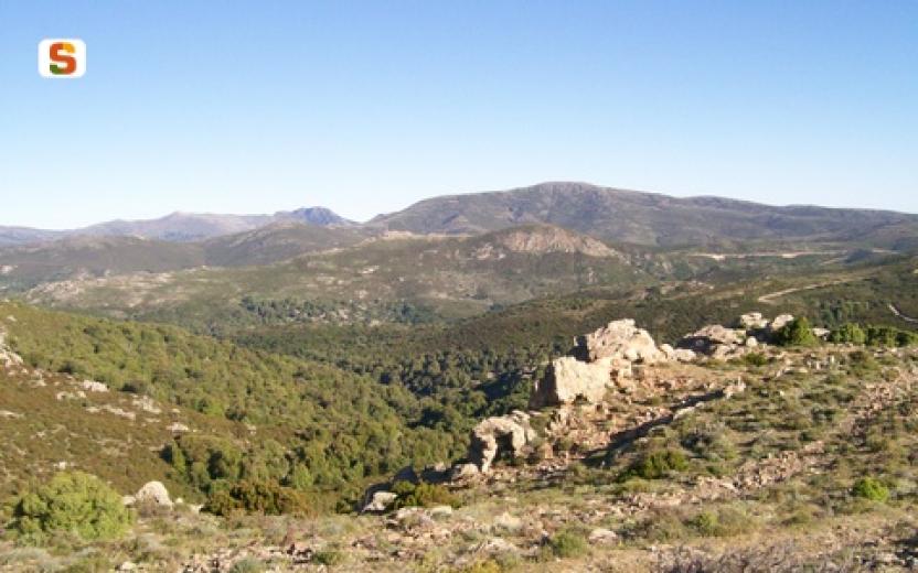
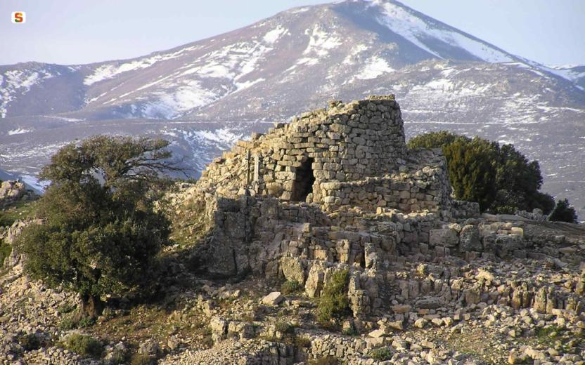
Take the dirt track that gains height for a few dozen metres, then continue on the flat illuminated ridge covered with Mediterranean scrub. The road is extraordinarily panoramic and it is possible to admire a large portion of the lake, with the characteristic contrasts between the colours of the water and the surrounding woods that confers its beauty. The dirt road proceeds bending slightly to the left and gradually plunges into a forest of cork trees and evolved Mediterranean scrub, coming to a fork where you continue straight ahead. Some tens of meters apart, slightly downhill, are some granite boulders that you will encounter: you are in the locality of Iscrithola and here you find a domus de Janas necropolis with five tombs, excavated directly into the boulders, while a large cavern in a larger boulder shows a paved floor and signs of long anthropogenic presence 

Il lago

Continue for a short distance, ignoring some minor detours to the left and then taking a right at an obvious fork. You are now almost back at lake and proceed in a south-easterly direction, still keeping to the main road. After passing a small building, you return to the SS 128 via a gate that must be closed again. Here you could return to Sa Valasa, however you can continue to the left, over the bridge, after which you go down, along an recognisable dirt road in the direction of the lake, on the right. Here begins a splendid path that runs alongside the lake, always shaded by the forest, following the gentle contours of the banks and with a few slopes. Occasionally, you will come across a few areas equipped for resting with wooden benches and tables. The last section of the route bypasses the Hotel Taloro accommodation facility, beyond which a short dirt road leads back to the SS 128, through which it is possible to easily return to Sa Valasa and Gavoi. For those who wish to extend the excursion, it is possible, from the Hotel Taloro, to cross the road and make a large loop along the Riu Perdas Fittas, in the Aratu valley, where a series of dirt roads lead to the river and some menhirs still standing vertically.

Lenght 20.200 m

gavoi.gpx

Total elevation gain 690 metri

Gavoi, Gusana. Il lago tra le montagne

Accesso 

Dal centro abitato si prende la SS 128 in direzione di Ovodda, in discesa, fino ad incontrare sulla destra le indicazioni per l’Hotel-Ristorante Sa Valasa. Si è ormai sulle sponde del bel Lago di Gusana, il vasto invaso nato per la produzione di energia e circondato da fitti boschi. Sulla sinistra della strada, poco oltre la deviazione per l’Hotel dove è possibile lasciare l’auto, si incontra una strada sterrata in salita.

 S’Iscrithola 

Si imbocca la sterrata che guadagna quota per qualche decina di metri, proseguendo poi in piano immersa in un costone soleggiato e coperto di macchia mediterranea. La strada è straordinariamente panoramica ed è possibile ammirare una vasta porzione di lago, con i caratteristici contrasti tra i colori dell’acqua e dei boschi circostanti che ne hanno decretato la fortuna. La sterrata procede piegando leggermente a sinistra e si immerge gradualmente in un bosco di sughere e macchia evoluta, incontrando un bivio dove si prosegue dritti. 

Poche decine di metri, in leggera discesa, separano dall’incontro con alcuni massi granitici: si è in località Iscrithola e qui si trova una necropoli a Domus de Janas che conta 5 tombe, scavate direttamente nei macigni, mentre un grande antro in un masso più grande mostra un fondo pavimentato e segni di lunga frequentazione antropica. 

Il lago 

Si prosegue ancora per un breve tratto, ignorando alcune deviazioni minori sulla sinistra e prendendo poi a destra ad un bivio evidente. Si è tornati quasi alla quota del lago e si procede in direzione sudest, tenendo sempre la strada principale. Superato un piccolo edificio si ritorna alla SS 128 per un cancello che è opportuno richiudere. Qui si potrebbe tornare a Sa Valasa ma si può proseguire a sinistra, sul ponte, superato il quale si scende per una evidente sterrata in direzione del lago, sulla destra. Qui inizia uno splendido sentiero che costeggia il lago, sempre ombreggiato dal bosco, seguendo il dolce andamento delle sponde e con scarse pendenze. Saltuariamente, si incontrano alcune aree attrezzate per la sosta con panche e tavoli di legno

L’ultimo tratto del percorso aggira la struttura ricettiva dell’Hotel Taloro, oltre il quale una breve sterrata riconduce alla SS 128, tramite la quale è possibile ritornare facilmente a Sa Valasa e a Gavoi. Per chi volesse prolungare l’escursione è possibile, dall’Hotel Taloro, attraversare la strada e compiere un grande anello lungo il Riu Perdas Fittas, nella valle di Aratu, dove una serie di strade sterrate conducono al fiume e ad alcuni Menhir ancora in posizione verticale.

Lenght 20.200 m

gavoi.gpx

Total elevation gain 690 metri

Sentiero Italia (Stage Z08) Alà dei Sardi – Caserma Giuanne Stuppa

Overview of the itinerary

Sentiero Italia runs the length of the island’s eastern side, covering its most important mountains, in 28 stages.  Starting from the north: it flanks the Monte Limbara massif, crosses the limestones of Mont’Albo and Tuttavista, skirting the Gulf of Orosei, it crosses the Supramonte, Gennargentu and the Tacchi of Ogliastra and reaches Perdasdefogu.  Further south, it passes through Armungia and the Gerrei sub-region. Lastly, it touches on the villages of Burcei and San Gregorio, continuing on the Sette Fratelli massif to the old prisons of Castiadas.

General information on Sentiero Italia (Grand Italian Trail)

Sentiero Italia, or Grand Italian Trail, as also explained on the official website, is a walking route that crosses the whole of Italy, using mainly but not exclusively “registered trails”.   
In particular, in Sardinia, not all the stages of the Sentiero Italia of CAI (Italian Alpine Club) are made of trails already included in the registry of the Sardinia Trail Network (RES), either because they have not yet been tested and approved or simply because they cannot be registered as they do not meet the requirements.  However, as a whole, the Sentiero Italia is the single longest walking route currently crossing Sardinia from the north (S. Teresa Gallura, stage Z 1) to the south (Castiadas, end of stage Z 28), touching on the most fascinating mountain areas in central-eastern Sardinia: the plateau of Buddusò, Tepilora, the Cedrino river valley, the ancient forests of Montes, Perda Liana and the regional forest of Montarbu, Monte Genis, and lastly the regional forest of Settefratelli (among the many crossed by the various stages of this long hiking itinerary).

Information on this stage of the trail

The last leg in the territory of Sassari leads to the nuraghe Boddò , strategically located on an imposing granite hill within sight of several other nuraghi in the surrounding area. 

You will then cross the valley of Rio Altana with beautiful pools of clear water to be admired while searching for the river crossing point. 

After passing through part of the Tepilora Regional Park, you will reach the Giuanne Stuppa forest ranger station where you can stay overnight.

Notes

The ford across the rio Altana can be challenging (it may be impassable in the winter months). At the Giuanne Stuppa stop point there is a Fo.Re.S.T.A.S. station, where it is currently only possible to stay overnight pitching a tent.

Lenght 20.500 m

SI Z08.gpx

Total elevation gain 601 metri

Geographical area Monteacuto

Sentiero Italia (Tappa Z08) Alà dei Sardi – Caserma Giuanne Stuppa

In sintesi

Il Sentiero Italia attraversa in lunghezza il settore orientale dell’isola toccandone i sistemi montuosi più rilevanti, in 28 tappe.  Partendo da nord: tocca il massiccio del Monte Limbara, attraversa i calcari del Mont'Albo e del Tuttavista sfiorando il Golfo di Orosei,  attraversa il Supramonte, il Gennargentu, i Tacchi dell’Ogliastra e giunge a Perdasdefogu.  Più a sud, transita da Armungia e dalla subregione del Gerrei. Infine tocca l’abitato di Burcei e San Gregorio, per continuare nel massiccio dei Sette Fratelli fino alle vecchie carceri di Castiadas.

Informazioni generali sull'itinerario sentiero Italia

Il Sentiero Italia, come spiegato anche nel sito ufficiale, è un itinerario (o Cammino) lungo tutta l'Italia, che utilizza prevalentemente ma non esclusivamente "sentieri accatastati".   
In particolare, in Sardegna, non tutte le tappe del Sentiero Italia del CAI coincidono con sentieri già inseriti nel catasto della Rete Escursionistica della Sardegna (RES), perché non hanno ancora superato le verifiche di percorribilità oppure semplicemente perché non possono essere accatastati non avendone i requisiti.  Tuttavia, nel suo insieme, il Sentiero Italia rappresenta l'unica, la più grande dorsale escursionistica che attraversa attualmente la nostra Isola da nord (S. Teresa Gallura, tappa Z 1) a sud (Castiadas, fine tappa Z 28) toccando le aree montane della Sardegna centro-Orientale più affascinanti: l'altopiano di Buddusò, Tepilora, la valle del Cedrino, i boschi vetusti di Montes, Perda Liana e la foresta demaniale di Montarbu, il Monte Genis, e infine la foresta demaniale di Settefratelli (tra le tante attraversate dal lungo itinerario escursionistico a tappe).

Info sul percorso di questa tappa

Quest'ultima tappa in terra sassarese ci porta inizialmente nei pressi del nuraghe Boddò situato in posizione strategica su un’imponente altura granitica a contatto visivo con una serie di altri nuraghe nel circondario. 

Successivamente si attraversa la valle creata dal Rio Altana (entrando quindi nel Parco Naturale Regionale di Teipilora) con splendide pozze di acqua limpida da ammirare alla ricerca di un punto per il guado.  NOTA: da questo punto, l'itinerario utilizza il sentiero RES accatastato come G-210 (dal guado sul rio Altana alla caserma Juanne Stuppa). 

Dopo aver attraversato una parte del Parco Regionale di Tepilora si giunge alla caserma forestale Giuanne (Juanne) Stuppa - ove è possibile pernottare.

Note

Guado difficoltoso sul rio Altana nei mesi invernali. Nel posto tappa Jiuanne Stuppa è presente una caserma dell'Agenzia Regionale Fo.Re.S.T.A.S. (ceduta in parte in gestione al Parco Regionale di Tepilora) dove attualmente è possibile solo il bivacco con tenda.

Informazioni utili

Lungo il percorso non sarà sempre presente la copertura telefonica. 
Non tutto il percorso di questa tappa del Sentiero Italia coincide con sentieri ufficiali della RES (Rete Escursionistica della Sardegna).

La tappa successiva (Z9) inizia da Juanne Stuppa proseguendo lungo vari sentieri della RES: il 220, il 230 e il 110 per giungere a Sant'Anna di Lodè.

Lenght 20.500 m

SI Z08.gpx

Total elevation gain 601 metri

Geographical area Monteacuto

Contiene carte
Spento

CMSB - STAGE 01 – FROM IGLESIAS TO NEBIDA

As of this first stage, we are walking on the most ancient limestone-dolomite rocks in Italy, on big deposits of lead, zinc and silver that have been the subject of intense mining activity for centuries. Straight away we are immersed in the great cultural, environmental and religious heritage of Sardinia.

From the medieval city of Iglesias to the town of Nebida, we encounter chapels, churches and places of worship dedicated to the patron saint of miners.

The passage in the sanctuary of the Madonna del Buon Cammino gives this first day a particular spiritual meaning.

On the average this stage is demanding, not so much for the length, as for the two uphill stretches that must be climbed in the first part of the walk in order to reach the Buon Cammino hilltop (341 masl) and the excavations of Cungiaus (323 masl).

Safety and useful tips

To get to the Buon Cammino, you need to walk along urban streets in the historic centre of Iglesias, so pay attention to crossings.

After leaving the Monastero del Buon Cammino, you will follow a dirt road that heads north. This stretch of the route runs alongside fences that delimit and prevent the passage to certain caves/excavations - do not cross the fences and follow the route.

To get to Monte Agruxiau you have to cross the SP84 road as it bypasses Iglesias and then take the asphalted road to cross Monte Agruxiau - watch out for vehicular traffic. The same attention must be paid when arriving in Nebida, where you will cross the hamlet through an asphalted road.

Some passages, despite being on a wide and comfortable roadway, may be exposed to falling from above - do not lean towards the exposed part and, if necessary, keep to the centre or to the upstream side of the roadway.

There are various old structures along the route; in most cases, they are fenced off, but in some cases, they may be open - do not venture inside them and always admire them from a distance.

A variant of the route allows you to reach the center of Monteponi using the city road network (Via Cattaneo/Vivaldi/Sassu).

ATTENTION

There is a detour due to work in progress on the path after the Monastero del Buon Cammino, temporary signs are already present on site.


Informazioni utili

The stage is moderately challenging, not only because of its length (21 km, 7 hours) but also due to the two uphill climbs that must be overcome in the first part of the route to reach the Buon Cammino hill (339 m/a.s.l.) and the archaeological excavations of Cungiaus (323 m/a.s.l.).
FOR UPDATED INFORMATION, CONSULT THE STAGE SHEET ON THE OFFICIAL WEBSITE


Lenght 21.000 m

Links

tappa-01-da-iglesias-nebida.gpx

Total elevation gain 901 metri

Geographical area Iglesiente

Elevation gain 753 metri

Negative elevation 797 metri

CMSB - TAPPA 1: DA IGLESIAS A NEBIDA

Dalla città medioevale di Iglesias fino al villaggio di Nebida, incontriamo cappelle, chiese e edifici di culto dedicati alla santa patrona dei minatori.

Il passaggio nel santuario della Madonna del Buon Cammino regala a questa prima giornata un particolare significato spirituale. Sin dalla prima tappa, camminiamo sulle rocce calcareo-dolomitiche più antiche d’Italia, sui grandi giacimenti di piombo, zinco e argento che per secoli sono stati oggetto di un’intensa attività estrattiva. Subito ci immergiamo nel grande patrimonio culturale, ambientale e religioso della Sardegna.

Una variante del percorso  permette di raggiungere  il centro di Monteponi utilizzando la rete viaria cittadina (Via Cattaneo/Vivaldi/Sassu).  

Informazioni utili

La tappa è mediamente impegnativa, non solo per la lunghezza (21 km, 7 ore) quanto per i due strappi in salita che occorre superare nella prima parte del percorso per raggiungere il colle del Buon Cammino (339 m/slm) e gli scavi di Cungiaus (323 m/slm).  
PER LE INFORMAZIONI AGGIORNATE, CONSULTA LA SCHEDA DELLA TAPPA, SUL SITO UFFICIALE 

Il Cammino Minerario di Santa Barbara

Si tratta del primo, tra i cammini sardi, ad essere stato iscritto al registro istituito dalla Regione Sarda nel 2012 con DGR48/9 ("Registro dei cammini di Sardegna, degli itinerari religiosi e dello spirito"). Attualmente è gestito dall'omonima Fondazione.

LA STORIA DEL PROGETTO

L’idea di costruire un itinerario nell’area più estesa e rappresentativa del Parco Geominerario Storico Ambientale della Sardegna, il Sulcis-Iglesiente-Guspinese, riscoprendo gli antichi cammini minerari oggi in gran parte abbandonati, è nata dai volontari dell’Associazione ONLUS Pozzo Sella Per il Parco Geominerario a seguito della grande partecipazione dei cittadini alle escursioni organizzate dalla stessa associazione dopo aver reso fruibili numerosi percorsi minerari.

Con il Cammino Minerario di Santa Barbara si vuole perseguire l’obiettivo di tramandare la memoria degli uomini che nei secoli e nei millenni passati hanno realizzato e percorso gli antichi cammini minerari con il piacere di riscoprire a passo lento la bellezza del territorio.

Un Protocollo d’intesa è stato sottoscritto tra i Comuni di Iglesias, Buggerru, Fluminimaggiore, Arbus, Guspini, Gonnosfanadiga, Villacidro, Domusnovas, Musei, Villamassargia. Narcao, Nuxis, Santadi, Piscinas, Giba, Masainas, San Giovanni Suergiu, Sant’Antioco, Carbonia e Gonnesa, le Diocesi di Iglesias e di Ales Terralba, le Province di Carbonia Iglesias e del Medio Campidano, il Consorzio del Parco Geominerario Storico Ambientale della Sardegna, l’ANCI SARDEGNA e l’Associazione Pozzo Sella: si tratta di un  partenariato per la costruzione e la gestione dell’itinerario storico, culturale, ambientale e religioso denominato “Cammino Minerario di Santa Barbara”.

PER MAGGIORI INFORMAZIONI, DETTAGLI E INFO AGGIORNATE SULLE TAPPE

Si consiglia di consultare il sito ufficiale del cammino: www.camminominerariodisantabarbara.org/

Lenght 21.000 m

Links

tappa-01-da-iglesias-nebida.gpx

Total elevation gain 901 metri

Roadbook

La tappa è mediamente impegnativa, non tanto per la lunghezza, quanto per i due strappi in salita che occorre superare nella prima parte del percorso per raggiungere il colle del Buon Cammino (339 m/slm) e gli scavi di Cungiaus (323 m/slm). Dalla città medioevale di Iglesias fino al villaggio di Nebida, incontriamo cappelle, chiese e edifici di culto dedicati alla santa patrona dei minatori.

Geographical area Iglesiente

Elevation gain 753 metri

Negative elevation 797 metri