Accessible trails
Sentieri per tutti...in questa categoria rientrano i sentieri progettati o riadattati perchè il contatto con l'ambiente naturale sia sempre di stimolo al miglioramento della vita personale di chiunque, con attenzione alle condizioni di disabilità motoria, sensoriale o della sfera psichica e relazionale...

Image credits Sardegna Digital Library Regione Sardegna
Results
Pathways Piscina Irgas (D-113)
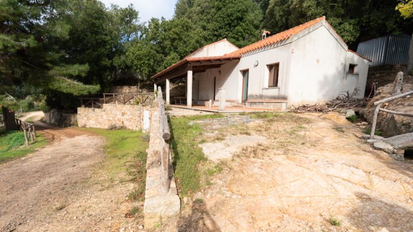
Piscina Irgas - Starting Point D-113
Attention! Trail for Expert Hikers (EE)
You leave trail 101, beginning to descend southwest, following a trail trace that winds through rocky bands and the maquis. Gradually you turn northeast, entering a steep and difficult gully, cluttered with Phillyrea trees and large myrtle plants. The descent is complicated and the landslide terrain requires caution.
Piscina Irgas - Punto di partenza D-113
Attenzione! tratto per Escursionisti Esperti (EE)
Ci si distacca dal sentiero 101 cominciando a scendere in direzione sudovest, seguendo una traccia di sentiero che serpeggia tra fasce rocciose e la macchia. Gradualmente si gira in direzione nordest, imboccando un impluvio ripido e difficile, ingombro di alberi di fillirea e grosse piante di mirto. La discesa è complicata ed il terreno franoso impone cautela.
Genna Piscina Irgas - D-113 arrival point - D-100 junction
General description
Trail 113 is the historic Linas route that led to Piscina Irgas. In 2022, the route was shortened because the first section (from the Cannisoni River to Punta Piscina Irgas and Genna 'e Piscina Irgas) was incorporated into trail D-100 (long-distance backbone also known as the "high route of Western Linas"). For this reason, to avoid unnecessary overlaps, 113 is now assigned only to the section (loop) that:
- It starts from Punta Piscina Irgas (at the intersection with the 100 ridge trail).
- You reach the waterfall by descending a steep and rocky gully
- It crosses and detaches from the riverbed, beginning a very steep ascent on loose ground, making tight switchbacks among the rocks and the scrub, sometimes with splendid views of the Rio Oridda course in its section downstream from the waterfall.
The descent and ascent are very steep, but short. At the summit, path 113 allows you to connect to path 100.
Note: The two ends of the 113 loop are less than 10' apart (along path 100).
Note: Some sections of this route, especially after rain, are for Expert Hikers (EE)
How to get here
From the point downstream of the waterfall, ascend along a well-maintained trail by the Forestas Agency until you reach this connection point with the D-100 trail (Western Linas High Route) in this location - Genna 'e Piscina Irgas.
Genna Piscina Irgas - arrivo D-113 - snodo D-100
Descrizione generale
Il sentiero 113 è lo storico percorso del Linas che portava a Piscina Irgas. Nel 2022 il tracciato è stato ridotto, perché il primo tratto (dal Rio Cannisoni sino alla Punta Piscina Irgas e alla Genna 'e Piscina Irgas) è stato inglobato nel sentiero D-100 (dorsale di lunga percorrenza denominato anche "alta via del Linas Occidentale"). Per questo motivo, per evitare sovrapposizioni inutili, il 113 ora è assegnato al solo tratto (anello) che:
- parte da Punta Piscina Irgas (all'incrocio con la dorsale 100)
- arriva alla cascata, scendendo per un canalone scosceso e pietroso
- attravesa e si stacca dal greto cominciando una ripidissima risalita su terreno smosso, compiendo stretti tornantini tra le rocce e la macchia, talvolta con viste splendide sul corso del Rio Oridda nel suo tratto a valle della cascata.
La discesa e la salita sono molto ripide, ma brevi. Al culmine il percorso 113 permette di raccordarsi al sentiero 100.
Nota: I due capi dell'anello 113 distano (lungo il sentiero 100) meno di 10'.
Nota: Alcuni tratti di questo percorso, specie dopo le pioggie, sono per Escursionisti Esperti (EE)
How to get here
Dal punto a valle della cascata, si risale lungo un sentiero ben sistemato dall'Agenzia Forestas fino a raggiungere questo punto di connessione con il sentiero D-100 (alta via del Linas Occidentale) in questa località - Genna 'e Piscina Irgas.
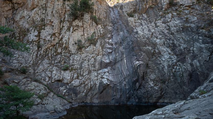
Piscina Irgas Waterfall
The Piscina Irgas waterfall is located in the municipality of Villacidro, in the province of South Sardinia. It is situated almost on the border with the territory of Domusnovas, surrounded by peaks reaching approximately 700 meters in height. It represents one of the most famous waterfalls in the municipal territory of Villacidro, along with Sa Spendula and Muru Mannu (or 'big wall' in Sardinian).
The waterfall has a drop of about 45 meters and originates from a gorge of Mount Piscina Irgas, which crosses the entire Oridda plateau and, flowing, descends throughout the valley until it joins the Rio Leni. Its jet, visible mainly in the winter season, after heavy and abundant rains, creates a series of natural water pools along almost the entire course of the Oridda river.
How to get here
The easiest way to reach the waterfall is via the D 113 hiking trail once you reach the Monti Mannu mountain (preferably via the D 100 trail, to which the 113 is connected). From there, the trail, which crosses the Rio Cannisoni, enters a dense holm oak forest. Along the way, there are continuous elevation changes with very narrow passages and dense vegetation, allowing you to reach the waterfall in about 2 hours of walking. From Punta Piscina Irgas, you can first see Punta Màgusu (more correctly Punta Cucuerris, also known as Punta Cannisoni, with a height of 1000 m) and in the distance Monte Linas, the highest mountain in all of Campidano.
Cascata Piscina Irgas
La cascata di Piscina Irgas è situata nel comune di Villacidro, nella provincia del Sud Sardegna. Si trova quasi al confine con il territorio di Domusnovas, circondata da vette che raggiungono i 700 m d'altezza circa. Rappresenta una delle cascate più famose presenti nel territorio comunale di Villacidro assieme a quella di Sa Spendula e di Muru Mannu (o grande muro) in sardo.
La cascata ha un salto di circa 45 m e nasce da un orrido del monte Piscina Irgas che attraversa tutto l’altopiano di Oridda e che, scorrendo scende per tutta la vallata fino a confluire con il Rio Leni. Con il suo getto, visibile prettamente nella stagione invernale, dopo piogge copiose e abbondanti, crea una serie di vasche d'acqua naturali lungo quasi tutto il percorso del fiume Oridda.
How to get here
Il modo più semplice per raggiungere la cascata è attraverso il sentiero escursionistico D 113 una volta che si raggiunge la montagna Monti Mannu (preferibilmente attraverso il sentiero D 100, al quale il 113 è collegato). Da lì il sentiero, che attraversa il Rio Cannisoni, si inoltra in una fitta lecceta. Lungo il cammino vi sono dei dislivelli continui con passaggi molto stretti e una fitta vegetazione, che permettono di raggiungere la cascata in circa 2 ore di camminata. Dalla Punta Piscina Irgas è possibile vedere in primis Punta Màgusu (più correttamente Punta Cucuerris, detta anche Punta Cannisoni, con un'altezza di 1000 m) e in lontanza il Monte Linas, la montagna più alta di tutto il Campidano.