Accessible trails
Sentieri per tutti...in questa categoria rientrano i sentieri progettati o riadattati perchè il contatto con l'ambiente naturale sia sempre di stimolo al miglioramento della vita personale di chiunque, con attenzione alle condizioni di disabilità motoria, sensoriale o della sfera psichica e relazionale...

Image credits Sardegna Digital Library Regione Sardegna
Results
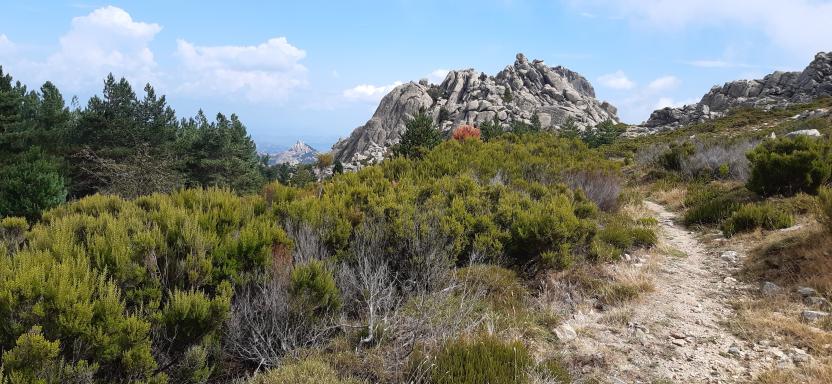
Sentiero Italia (Stage Z06) Monti – Caserma Forestale Bolostiu
Overview of the itinerary
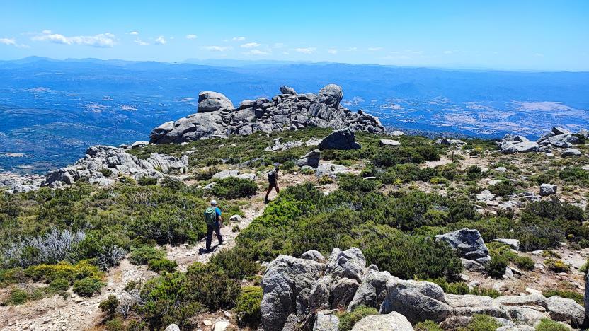
Sentiero Italia runs the length of the island’s eastern side, covering its most important mountains, in 28 stages. Starting from the north: it flanks the Monte Limbara massif, crosses the limestones of Mont’Albo and Tuttavista, skirting the Gulf of Orosei, it crosses the Supramonte, Gennargentu and the Tacchi of Ogliastra and reaches Perdasdefogu. Further south, it passes through Armungia and the Gerrei sub-region. Lastly, it touches on the villages of Burcei and San Gregorio, continuing on the Sette Fratelli massif to the old prisons of Castiadas.
General information on Sentiero Italia (Grand Italian Trail)
Sentiero Italia, or Grand Italian Trail, as also explained on the official website, is a walking route that crosses the whole of Italy, using mainly but not exclusively “registered trails”.
In particular, in Sardinia, not all the stages of the Sentiero Italia of CAI (Italian Alpine Club) are made of trails already included in the registry of the Sardinia Trail Network (RES), either because they have not yet been tested and approved or simply because they cannot be registered as they do not meet the requirements. However, as a whole, the Sentiero Italia is the single longest walking route currently crossing Sardinia from the north (S. Teresa Gallura, stage Z 1) to the south (Castiadas, end of stage Z 28), touching on the most fascinating mountain areas in central-eastern Sardinia: the plateau of Buddusò, Tepilora, the Cedrino river valley, the ancient forests of Montes, Perda Liana and the regional forest of Montarbu, Monte Genis, and lastly the regional forest of Settefratelli (among the many crossed by the various stages of this long hiking itinerary).
Information on this stage of the trail
The starting point is the village of Monti, near the Vermentino winery. After walking a little less than 2 km on a blacktop road, used by local traffic, a 2.3 km stretch on a livestock trail begins. From here the route is on a path, for about 1 km, to the Sos Sambinzos locality (in this stretch there are two fords on the rio Crasta), from where the trail will take you back to a livestock trail that will lead you, through private land (with stiles to pass over the boundary wall) to the Monte Olia regional forest. The forest is crossed by several tracks, which are used by the Forest Rangers also for wildfire control. In this stretch, you can deviate slightly from the route to stop at the ‘Pedra Bianca’ spring and the nearby hut, fairly comfortable and freely accessible, used by the staff of Fo.Re.S.T.A.S.
After retracing your steps back from the spring, to the main trail, continue on a dirt road towards the ford on the Seleme river. Along its course, the river forms beautiful natural pools known as ‘Salomone’, some of which are near the ford.
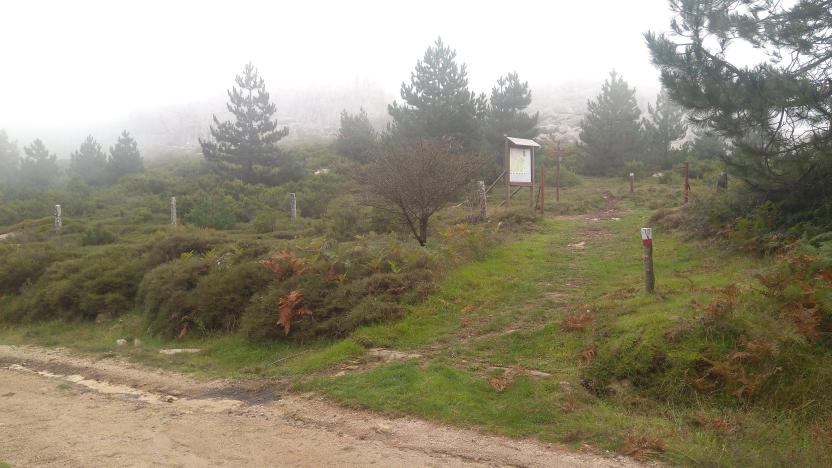
After crossing the river, the route climbs up a trail that follows a firebreak, and then continues on a dirt road to the ‘Bolostiu’ forest ranger station. If the Seleme river is impassable, you must head, within the regional forest, towards the forest ranger station of Monte Olia, bordering road SS 389, which connects Monti with Alà dei Sardi, and return to the path from the blacktop road heading to the village of Badde Suelzu.
Notes
The ford across the Seleme river can be challenging (it may be impassable in the winter months but you can take an alternative route via SS 389).
At the Bolostiu stop point there is a station of the Fo.Re.S.T.A.S. Regional Agency.. At present, accommodation is not available but hikers can pitch their tent.
Informazioni utili
Tipologia itinerario
- Log in to post comments
Photogallery
Sentiero Italia (Tappa Z06) Monti – Caserma Forestale Bolostiu
In sintesi
Il Sentiero Italia attraversa in lunghezza il settore orientale dell’isola toccandone i sistemi montuosi più rilevanti, in 28 tappe. Partendo da nord: tocca il massiccio del Monte Limbara, attraversa i calcari del Mont'Albo e del Tuttavista sfiorando il Golfo di Orosei, attraversa il Supramonte, il Gennargentu, i Tacchi dell’Ogliastra e giunge a Perdasdefogu. Più a sud, transita da Armungia e dalla subregione del Gerrei. Infine tocca l’abitato di Burcei e San Gregorio, per continuare nel massiccio dei Sette Fratelli fino alle vecchie carceri di Castiadas.
Informazioni generali sull'itinerario sentiero Italia
Il Sentiero Italia, come spiegato anche nel sito ufficiale, è un itinerario (o Cammino) lungo tutta l'Italia, che utilizza prevalentemente ma non esclusivamente "sentieri accatastati".
In particolare, in Sardegna, non tutte le tappe del Sentiero Italia del CAI coincidono con sentieri già inseriti nel catasto della Rete Escursionistica della Sardegna (RES), perché non hanno ancora superato le verifiche di percorribilità oppure semplicemente perché non possono essere accatastati non avendone i requisiti. Tuttavia, nel suo insieme, il Sentiero Italia rappresenta l'unica, la più grande dorsale escursionistica che attraversa attualmente la nostra Isola da nord (S. Teresa Gallura, tappa Z 1) a sud (Castiadas, fine tappa Z 28) toccando le aree montane della Sardegna centro-Orientale più affascinanti: l'altopiano di Buddusò, Tepilora, la valle del Cedrino, i boschi vetusti di Montes, Perda Liana e la foresta demaniale di Montarbu, il Monte Genis, e infine la foresta demaniale di Settefratelli (tra le tante attraversate dal lungo itinerario escursionistico a tappe).
Info sul percorso di questa tappa
Si parte dal centro abitato di Monti, in prossimità della cantina del Vermentino. Dopo aver percorso poco meno di 2 km su strada asfaltata, con presenza di traffico locale, inizia il tratto su tratturo che si percorre per circa 2,3 km. Da questo punto il percorso è su sentiero, per poco più di un km, fino alla località Sos Sambinzos (in questo tratto sono presenti due guadi sul rio Crasta), dove riprendiamo un tratturo che ci porterà, attraversando anche una proprietà privata (con apposite scalette messe in opera nella recinzione) ad entrare nella foresta demaniale di Monte Olia. All'interno del demanio sono presenti numerose piste più o meno utilizzate dal personale anche per la gestione antincendio. In questo tratto si è previsto una piccola deviazione per la presenza di una sorgente "Pedra Bianca" e di un locale di ricovero abbastanza confortevole e di libero accesso, utilizzato dal personale di Fo.Re.S.T.A.S.
Ripercorso il breve tratto che ci ha portato alla sorgente, si prosegue su sterrata in direzione del guado sul fiume Seleme. Questo fiume lungo il suo percorso forma delle piscine naturali molto belle conosciute con il nome “Salomone”, alcune nei pressi del guado.
Attraversato il fiume ci si inerpica, su sentiero realizzato all'interno di una fascia frangifuoco, per poi proseguire su sterrata fino alla caserma forestale di "Bolostiu". Nell'eventualità il fiume Seleme non sia attraversabile è necessario dirigersi, all'interno del demanio forestale, in direzione della caserma forestale di Monte Olia confinante con la S.S. 389 che collega Monti con Alà dei Sardi e riprendere il sentiero utilizzando la strada asfaltata per il borgo di Badde Suelzu.
Note
Guado difficoltoso sul fiume Seleme (impraticabile nei mesi invernali ma con possibile via di "fuga" su S.S. 389).
Nel posto tappa Bolostiu è presente una caserma dell'Agenzia Regionale Fo.Re.S.T.A.S.. Attualmente solo possibilità di pernottamento con tenda.
Informazioni utili
Lungo il percorso non sarà sempre presente la copertura telefonica
Tipologia itinerario
- Log in to post comments
Photogallery
Sentiero Italia (Stage Z04) Sant’Antonio di Gallura – Calangianus
Overview of the itinerary
Sentiero Italia runs the length of the island’s eastern side, covering its most important mountains, in 28 stages. Starting from the north: it flanks the Monte Limbara massif, crosses the limestones of Mont’Albo and Tuttavista, skirting the Gulf of Orosei, it crosses the Supramonte, Gennargentu and the Tacchi of Ogliastra and reaches Perdasdefogu. Further south, it passes through Armungia and the Gerrei sub-region. Lastly, it touches on the villages of Burcei and San Gregorio, continuing on the Sette Fratelli massif to the old prisons of Castiadas.
General information on Sentiero Italia (Grand Italian Trail)
Sentiero Italia, or Grand Italian Trail, as also explained on the official website, is a walking route that crosses the whole of Italy, using mainly but not exclusively “registered trails”.
In particular, in Sardinia, not all the stages of the Sentiero Italia of CAI (Italian Alpine Club) are made of trails already included in the registry of the Sardinia Trail Network (RES), either because they have not yet been tested and approved or simply because they cannot be registered as they do not meet the requirements. However, as a whole, the Sentiero Italia is the single longest walking route currently crossing Sardinia from the north (S. Teresa Gallura, stage Z 1) to the south (Castiadas, end of stage Z 28), touching on the most fascinating mountain areas in central-eastern Sardinia: the plateau of Buddusò, Tepilora, the Cedrino river valley, the ancient forests of Montes, Perda Liana and the regional forest of Montarbu, Monte Genis, and lastly the regional forest of Settefratelli (among the many crossed by the various stages of this long hiking itinerary).
Information on this stage of the trail
After crossing Sant’Antonio di Gallura, after a short stretch of tarmac road, the route turns left in a southerly direction towards the Tradimentu stazzo (farmhouse), along a dirt track. Then take a tarmac road in a south-westerly direction until you reach a roundabout. From there, continue, still in a south-westerly direction, along a small tarmac road until you cross a small bridge over a small stream. Right after the bridge turn left onto an old, little-used livestock trail that leads to an abandoned granite quarry. As the path is uphill, here you can enjoy beautiful views, surrounded by rocks shaped by nature. Continue crossing the land of the Giagucciu stazzo (farmhouse), dotted with beautiful olive trees. Continue, still on a dirt road (in poor conditions in some places), until you reach a short stretch of tarmac road in the direction of the small church of San Tommaso, which has a beautiful juniper wood altar. Here you can take a break at the nearby picnic area before starting the ascent towards Calangianus. Continue on a dirt road for about 7 km, still uphill, reaching above 700 m asl. A final stretch of blacktop road will take you to the village of Calangianus.
Informazioni utili
Tipologia itinerario
- Log in to post comments
Photogallery
Sentiero Italia (Tappa Z04) Sant’Antonio di Gallura – Calangianus
In sintesi
Il Sentiero Italia attraversa in lunghezza il settore orientale dell’isola toccandone i sistemi montuosi più rilevanti, in 28 tappe. Partendo da nord: tocca il massiccio del Monte Limbara, attraversa i calcari del Mont'Albo e del Tuttavista sfiorando il Golfo di Orosei, attraversa il Supramonte, il Gennargentu, i Tacchi dell’Ogliastra e giunge a Perdasdefogu. Più a sud, transita da Armungia e dalla subregione del Gerrei. Infine tocca l’abitato di Burcei e San Gregorio, per continuare nel massiccio dei Sette Fratelli fino alle vecchie carceri di Castiadas.
Informazioni generali sull'itinerario sentiero Italia
Il Sentiero Italia, come spiegato anche nel sito ufficiale, è un itinerario (o Cammino) lungo tutta l'Italia, che utilizza prevalentemente ma non esclusivamente "sentieri accatastati".
In particolare, in Sardegna, non tutte le tappe del Sentiero Italia del CAI coincidono con sentieri già inseriti nel catasto della Rete Escursionistica della Sardegna (RES), perché non hanno ancora superato le verifiche di percorribilità oppure semplicemente perché non possono essere accatastati non avendone i requisiti. Tuttavia, nel suo insieme, il Sentiero Italia rappresenta l'unica, la più grande dorsale escursionistica che attraversa attualmente la nostra Isola da nord (S. Teresa Gallura, tappa Z 1) a sud (Castiadas, fine tappa Z 28) toccando le aree montane della Sardegna centro-Orientale più affascinanti: l'altopiano di Buddusò, Tepilora, la valle del Cedrino, i boschi vetusti di Montes, Perda Liana e la foresta demaniale di Montarbu, il Monte Genis, e infine la foresta demaniale di Settefratelli (tra le tante attraversate dal lungo itinerario escursionistico a tappe).
Info sul percorso di questa tappa
- manca descrizione -
Informazioni utili
Lungo il percorso non sarà sempre presente la copertura telefonica
Tipologia itinerario
- Log in to post comments
Photogallery
Sentiero Italia (Stage Z03) Luogosanto – Sant’Antonio di Gallura
Overview of the itinerary
Sentiero Italia runs the length of the island’s eastern side, covering its most important mountains, in 28 stages. Starting from the north: it flanks the Monte Limbara massif, crosses the limestones of Mont’Albo and Tuttavista, skirting the Gulf of Orosei, it crosses the Supramonte, Gennargentu and the Tacchi of Ogliastra and reaches Perdasdefogu. Further south, it passes through Armungia and the Gerrei sub-region. Lastly, it touches on the villages of Burcei and San Gregorio, continuing on the Sette Fratelli massif to the old prisons of Castiadas.
General information on Sentiero Italia (Grand Italian Trail)
Sentiero Italia, or Grand Italian Trail, as also explained on the official website, is a walking route that crosses the whole of Italy, using mainly but not exclusively “registered trails”.
In particular, in Sardinia, not all the stages of the Sentiero Italia of CAI (Italian Alpine Club) are made of trails already included in the registry of the Sardinia Trail Network (RES), either because they have not yet been tested and approved or simply because they cannot be registered as they do not meet the requirements. However, as a whole, the Sentiero Italia is the single longest walking route currently crossing Sardinia from the north (S. Teresa Gallura, stage Z 1) to the south (Castiadas, end of stage Z 28), touching on the most fascinating mountain areas in central-eastern Sardinia: the plateau of Buddusò, Tepilora, the Cedrino river valley, the ancient forests of Montes, Perda Liana and the regional forest of Montarbu, Monte Genis, and lastly the regional forest of Settefratelli (among the many crossed by the various stages of this long hiking itinerary).
Information on this stage of the trail
Leaving the small town of Luogosanto, the route follows a local blacktop road in the direction of the Fonte La Filetta Park. At a fork in the road, it leaves the road leading to La Filetta Park and follows the road to the right in a south-westerly direction until it reaches the stile at the entrance to the stazzo (farmhouse) of Sesara. The route continues on a dirt track through private land, crossing gates that can be opened and then must be closed again. The route continues through the beautiful landscapes characteristic of Gallura, with granite rock outcrops, holm oaks and wild olive trees, until it reaches the small country church of San Biagio.
In Gallura there are many country churches around which, on feast days, lunches are organised for hundreds or even thousands of people.
Leaving the church of San Biagio, the route heads in the direction of the ford across the Liscia river.
PLEASE NOTE: this section of the trail is not marked as the landowner has not authorised the installation of signs. Once past the river, the route climbs up a path flanking a cliff and through a young forest of predominantly holm oaks and strawberry trees. At one time, this forest consisted of primary trees that were cut down for charcoal in the 19th century. Short sections of the path built at that time have been restored.
After leaving the trail, the route continues along a local road that runs alongside the Liscia lake. It continues on a livestock trail, on private property. On this stretch, you can admire an over 2000-year-old wild olive tree and the viaduct of a railway line now only used in the summer months as a tourist line. The trail arrives in Sant'Antonio di Gallura after following a stretch of blacktop road and, if you wish, after a detour to the railway station near Lake Liscia. Sant’Antonio is ‘heir’ to an ancient medieval village, Villa de Castro, built at the foot of the Lu Naracu nuraghe (prehistoric stone fortress) a few hundred metres from the ancient church of S. Andrea and from the current square in the centre of the village. The church of Sant’Andrea, which was built no later than the 1700s, belonged to the noble Pes family of Tempio Pausania.
Approximately 5 km from Sant’Antonio di Gallura, deviating on a farm road, is the farmhouse of Ms Santoli, who has preserved the original furnishings and collected photographs and interesting pieces of rural art over the years. In the immediate vicinity of the village are thousand-year-old wild olive trees. The area is also rich in archaeological heritage, including the Sarra di l'Aglientu megalithic wall near the Liscia lake. The countryside of Gallura is dotted with small country churches that, on feast days, celebrate their saints (each being named after its own saint) with festivals and feasts that have a strong social value. Lunch or dinner is always offered at these festivals. Some notable celebrations are the feast of S. Santino on 1 May; S. Giacomo on the first Sunday in May, on 25 July and the second Sunday in September; S. Giuseppe on the second Sunday in June; Nostra Signora della Crucitta on the second Sunday in May; S. Francesco on 4 October; S. Leonardo on the first Sunday in June.
Notes
The ford across the Liscia river can be challenging (it may be impassable in the winter months).
Trail signage to be completed for a short section.
Informazioni utili
Cell service will not always be available along the route.
In the rainy season, crossing the river can be difficult, although the water flow is controlled by the weir upstream of the ford.
Some stretches of this leg of the trail are on private land, in some cases without signposts, where landowners have not authorised the Italian Alpine Club (CAI) to install them.
FOR UP-TO-DATE INFORMATION, PLEASE READ THE FACT SHEET ON THE SENTIERO ITALIA WEBSITE
Tipologia itinerario
- Log in to post comments