Oliena (Su Carmene)
Nella parte alta del Paese, tra la provinciale 22 che sale a Maccione e le vie Sardegna e Limbara
Sentieri per tutti...in questa categoria rientrano i sentieri progettati o riadattati perchè il contatto con l'ambiente naturale sia sempre di stimolo al miglioramento della vita personale di chiunque, con attenzione alle condizioni di disabilità motoria, sensoriale o della sfera psichica e relazionale...

Image credits Sardegna Digital Library Regione Sardegna
Nella parte alta del Paese, tra la provinciale 22 che sale a Maccione e le vie Sardegna e Limbara
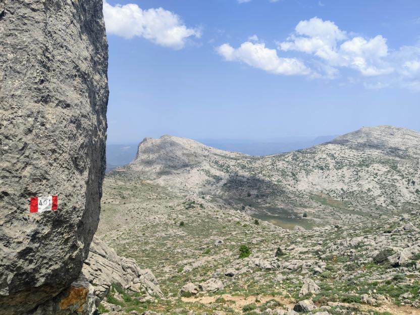
Viewpoint overlooking the entire valley west of Mount Corrasi, a junction point for various trails, there is a permanent bivouac (old sheepfold recently renovated by Forestas) with tables in the shade of centuries-old trees.
It can be reached along trail 401 from the town, in about 2 and a half hours and with a significant elevation gain.
Belvedere che domina su tutta la vallata a ovest del monte Corrasi, punto di snodo di vari sentieri, è presente un bivacco fisso (vecchio ovile recentemente ristrutturato da Forestas) con tavoli all'ombra di alberi secolari.
Si arriva lungo il sentiero 401 dal paese, circa 2 ore e mezza ed un notevole dislivello.
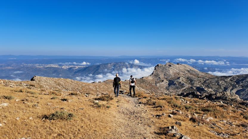
This short connecting path is a crucial junction, allowing you to leave trail 401 (from Su Carmene di Oliena to Punta Corrasi) and return to Mount Maccione, a rest stop, equipped parking area, and near a lodging facility.
A picturesque town, between the Supramonte and Nuoro areas, rich in limestone reliefs, deep sinkholes, canyons, and lush valleys. The surroundings of Oliena, a village in the Barbagia region at the foot of Mount Corrasi (1463 meters above sea level), ten kilometers from Nuoro, are an immense natural monument, ideal for trekking, hiking, and biking. The first settlement was Roman, a confluence of 'rebellious' peoples such as the Ilienses, according to Sallust, Trojans who took refuge on the Island. Today, the town, populated by about seven thousand inhabitants, boasts the Orange Flag, thanks to the nature, culture, craftsmanship, and hospitality of its community.
A FIRST intervention funded by regional funds (Program Agreement for the Inner Supramonte - Su Suercone) was carried out in 2018 by Forestas in the municipalities of Oliena-Orgosolo-Urzulei-Dorgali, then more recently (2022) Forestas again completed and harmonized the structure of the regional hiking network in the Municipality of Oliena thanks to European funds (ERDF POR). THIS ROUTE iSPART OF THE SENTIERO ITALIA that crosses the entire Supramonte along the main ridges, passing right through Corrasi.
It can be reached along trail 401.
Questo breve raccordo rappresenta uno snodo fondamentale e permette di abbandonare il sentiero 401 (da Su Carmene di Oliena a Punta Corrasi) per tornare a monte Maccione, punto di sosta, area attrezzata per il parcheggio e nelle vicinanze di una struttura ricettiva.
Un pittoresco paese, tra supramonte e nuorese, ricco di rilievi calcarei, profonde doline, canyon e valli rigogliose. I dintorni di Oliena, borgo della Barbagia ai piedi del monte Corrasi (1463 metri slm) a dieci chilometri da Nuoro, sono un immenso monumento naturale, ideale per trekking, hiking e biking. Il primo insediamento fu romano, confluenza di popoli ‘ribelli’ come gli Ilienses, secondo Sallustio, troiani rifugiatisi nell’Isola. Oggi il paese, popolato da circa settemila abitanti, si fregia della Bandiera arancione, merito di natura, cultura, artigianato e accoglienza della sua comunità.
Un primo intervento finanziato da fondi regionali (Accordo di programma per il Supramonte interno - Su Suercone) fu realizzato nel 2018 da Forestas nei comuni di Oliena-Orgosolo-Urzulei-Dorgali, poi più recentemente (2022) ancora Forestas ha completato ed armonizzato la struttura della rete escursionistica regionale in Comune di Oliena grazie a fondi europei (POR FESR). QUESTO PERCORSO è PARTE DEL SENTIERO ITALIA che attraversa il tutto il Supramonte lungo le creste principali, passando proprio attraverso il Corrasi.
Vi si arriva lungo il sentiero 401.
Located at an altitude of 695 meters above sea level, this crossroads is the junction between trail 401A (leading to 401 for Corrasi) and trail 403 (from Monti Hinele to Tuones).
It can also be reached by car directly from Oliena, along via Sardegna street and the concrete uphill road (provincial road 22).
Situato a un'altitudine di 695 metri sul livello del mare, questo incrocio è il punto di congiunzione tra il sentiero 401A (che conduce al 401 per Corrasi) e il sentiero 403 (da Monti Hinele a Tuones).
Si può raggiungere anche in auto direttamente da Oliena, attraverso via Sardegna e la salita in cemento (strada provinciale 22).