Start website main content

Horse

48 pathways

Ippovia è un itinerario percorribile a cavallo, raramente asfaltato, che attraversa riserve naturali, boschi, colline e vallate, talvolta costeggiando corsi d'acqua e spiagge, attraversando evidenze storiche-culturali o borghi. L'ippovia consente la pratica dell'equiturismo ma può anche essere percorsa a piedi.  Lungo il percorso si prevedono tappe, distanti non più di 20 km, dove cavaliere e cavallo possano trovare assistenza, ristoro ed eventuale pernottamento...

Ippoturismo.png

Results

Sentiero Italia (Stage Z21B) Ulassai - Jerzu

Overview of the itinerary

Sentiero Italia runs the length of the island’s eastern side, covering its most important mountains, in 28 stages.  Starting from the north: it flanks the Monte Limbara massif, crosses the limestones of Mont’Albo and Tuttavista, skirting the Gulf of Orosei, it crosses the Supramonte, Gennargentu and the Tacchi of Ogliastra and reaches Perdasdefogu.  Further south, it passes through Armungia and the Gerrei sub-region. Lastly, it touches on the villages of Burcei and San Gregorio, continuing on the Sette Fratelli massif to the old prisons of Castiadas.

General information on Sentiero Italia (Grand Italian Trail)

Sentiero Italia, or Grand Italian Trail, as also explained on the official website, is a walking route that crosses the whole of Italy, using mainly but not exclusively “registered trails”.   
In particular, in Sardinia, not all the stages of the Sentiero Italia of CAI (Italian Alpine Club) are made of trails already included in the registry of the Sardinia Trail Network (RES), either because they have not yet been tested and approved or simply because they cannot be registered as they do not meet the requirements.  However, as a whole, the Sentiero Italia is the single longest walking route currently crossing Sardinia from the north (S. Teresa Gallura, stage Z 1) to the south (Castiadas, end of stage Z 28), touching on the most fascinating mountain areas in central-eastern Sardinia: the plateau of Buddusò, Tepilora, the Cedrino river valley, the ancient forests of Montes, Perda Liana and the regional forest of Montarbu, Monte Genis, and lastly the regional forest of Settefratelli (among the many crossed by the various stages of this long hiking itinerary).

Information on this stage of the trail

The original stage was quite long, more than 28 km, so it has been split into two parts. 

Route 21B is the shortest section, about 10 km, ending in the small town of Ulassai, home to artist Maria Lai and a rock climbing mecca with many bolted routes of varying levels of difficulty. 

Leaving the town of Ulassai, follow a short stretch of via S’Arenargiu, where a weaving workshop is located, and a little further on, the fork for Monte Matzeu, which you should leave to your right to continue on a dirt track in a southerly direction. You will then take a path, still heading south, through a beautiful forest with the route sufficiently marked with stone cairns and, passing alongside Monte Tisiddu, you will come to a dirt track that leads, after passing several forks, to an easy path heading south-east. In this section you will find two springs, the first near a hut and the second near a small wooden cabin that can be used as a camping point if necessary. 

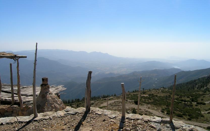
After passing alongside road SP 13, cross it to continue uphill on a stretch of paved road. At a crossroads, turn right in a westerly direction. Once you have passed a gate with a side passage and the fork leading to the fire lookout, you will find a fork with a scenic spot on the right. 

Back to the fork, continue in a westerly direction and then in a south-westerly direction towards the hotel-restaurant Rifugio d’Ogliastra (open all year round). You will then arrive at the stop point in the square of the country church of Sant’Antonio of Jerzu where there is a drinking fountain.

Lenght 9.300 m

SI Z21-B.gpx

Total elevation gain 403 metri

Sentiero Italia (Tappa Z21B) Ulassai - Jerzu

In sintesi

Il Sentiero Italia attraversa in lunghezza il settore orientale dell’isola toccandone i sistemi montuosi più rilevanti, in 28 tappe.  Partendo da nord: tocca il massiccio del Monte Limbara, attraversa i calcari del Mont'Albo e del Tuttavista sfiorando il Golfo di Orosei,  attraversa il Supramonte, il Gennargentu, i Tacchi dell’Ogliastra e giunge a Perdasdefogu.  Più a sud, transita da Armungia e dalla subregione del Gerrei. Infine tocca l’abitato di Burcei e San Gregorio, per continuare nel massiccio dei Sette Fratelli fino alle vecchie carceri di Castiadas.

Informazioni generali sull'itinerario sentiero Italia

Il Sentiero Italia, come spiegato anche nel sito ufficiale, è un itinerario (o Cammino) lungo tutta l'Italia, che utilizza prevalentemente ma non esclusivamente "sentieri accatastati".   
In particolare, in Sardegna, non tutte le tappe del Sentiero Italia del CAI coincidono con sentieri già inseriti nel catasto della Rete Escursionistica della Sardegna (RES), perché non hanno ancora superato le verifiche di percorribilità oppure semplicemente perché non possono essere accatastati non avendone i requisiti.  Tuttavia, nel suo insieme, il Sentiero Italia rappresenta l'unica, la più grande dorsale escursionistica che attraversa attualmente la nostra Isola da nord (S. Teresa Gallura, tappa Z 1) a sud (Castiadas, fine tappa Z 28) toccando le aree montane della Sardegna centro-Orientale più affascinanti: l'altopiano di Buddusò, Tepilora, la valle del Cedrino, i boschi vetusti di Montes, Perda Liana e la foresta demaniale di Montarbu, il Monte Genis, e infine la foresta demaniale di Settefratelli (tra le tante attraversate dal lungo itinerario escursionistico a tappe).

Info sul percorso di questa tappa

La tappa originaria essendo abbastanza lunga, oltre 28 km, si è preferito suddividerla in due parti. 

La 21B rappresenta il tratto più corto, circa 10 km e ben si presta per accogliere l’escursionista a inizio tappa nel centro abitato di Ulassai, il paese dell’artista Maria Lai e località con numerose vie su parete con vari gradi di difficoltà. 

Lasciato il centro abitato di Ulassai si percorre un breve tratto di via S’Arenargiu, dove si trova il laboratorio di tessitura, ed poco più avanti il bivio per Monte Matzeu che lasceremo alla nostra destra per proseguire su una sterrata in direzione Sud. Successivamente si percorre un sentiero, sempre in direzione Sud, che attraversa un bel bosco con il percorso sufficientemente individuato con omini di pietra e, costeggiando il Monte Tisiddu si arriva a percorrere una sterrata che ci porta, dopo aver superato alcuni bivi, ad un agevole sentiero in direzione Sud-Est. In questo tratto troviamo due sorgenti, la prima in prossimità di un capanno e la seconda nei pressi di una casetta in legno che in caso di necessità può essere utilizzata come bivacco. 

Dopo aver costeggiato la SP 13 la si attraversa per proseguire in salita su tratto di strada cementata. Arrivati ad un quadrivio si prende a destra in direzione Ovest. Superato un cancello con passaggio laterale ed il bivio che porta alla vedetta antincendio troviamo un bivio con una zona panoramica sulla destra. 

Ritornati al bivio continuiamo in direzione Ovest, successivamente verso Sud e poi in direzione Sud-Ovest verso l’hotel Ristorante Rifugio d'Ogliastra (aperto tutto l’anno) e successivamente arrivare al posto tappa nel piazzale della chiesa campestre di Sant’Antonio di Jerzu dove è presente una fontanella.

Informazioni utili

Lungo il percorso non sarà sempre presente la copertura telefonica

Lenght 9.300 m

SI Z21-B.gpx

Total elevation gain 403 metri

Contiene carte
Spento