High routes
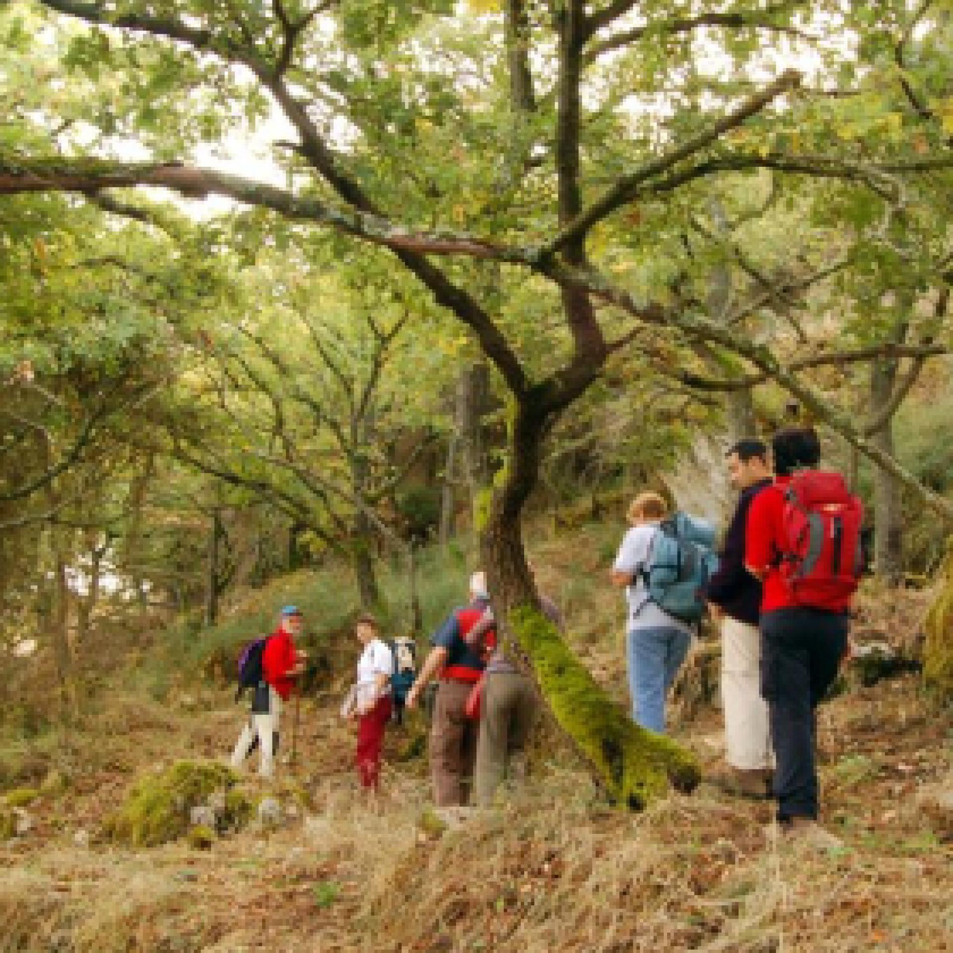
Pur senza cime particolarmente elevate, la Sardegna offre all'escursionista suggestivi itinerari oltre quota 1000 metri: si tratta di sentieri impegnativi, lungo crinali suggestivi attraverso le aree più selvagge dell'Isola, dove il panorama può cambiare drasticamente sui due versanti di una montagna. Orografia, geologia e lo storico isolamento rendono queste vette ricche di wilderness: con un po’ di fortuna potrai osservare mufloni e rapaci, scoprire lungo il percorso i ruderi di antichi villaggi, vecchi ovili e punti panoramici sorprendenti...
Results
Sentiero Italia (Stage Z09) Caserma Forestale Gianni Stuppa – Vecchia Cantoniera di Sant’Anna
Overview of the itinerary
Sentiero Italia runs the length of the island’s eastern side, covering its most important mountains, in 28 stages. Starting from the north: it flanks the Monte Limbara massif, crosses the limestones of Mont’Albo and Tuttavista, skirting the Gulf of Orosei, it crosses the Supramonte, Gennargentu and the Tacchi of Ogliastra and reaches Perdasdefogu. Further south, it passes through Armungia and the Gerrei sub-region. Lastly, it touches on the villages of Burcei and San Gregorio, continuing on the Sette Fratelli massif to the old prisons of Castiadas.
General information on Sentiero Italia (Grand Italian Trail)
Sentiero Italia, or Grand Italian Trail, as also explained on the official website, is a walking route that crosses the whole of Italy, using mainly but not exclusively “registered trails”.
In particular, in Sardinia, not all the stages of the Sentiero Italia of CAI (Italian Alpine Club) are made of trails already included in the registry of the Sardinia Trail Network (RES), either because they have not yet been tested and approved or simply because they cannot be registered as they do not meet the requirements. However, as a whole, the Sentiero Italia is the single longest walking route currently crossing Sardinia from the north (S. Teresa Gallura, stage Z 1) to the south (Castiadas, end of stage Z 28), touching on the most fascinating mountain areas in central-eastern Sardinia: the plateau of Buddusò, Tepilora, the Cedrino river valley, the ancient forests of Montes, Perda Liana and the regional forest of Montarbu, Monte Genis, and lastly the regional forest of Settefratelli (among the many crossed by the various stages of this long hiking itinerary).
Information on this stage of the trail
Athis fairly long leg of the trail crosses the Tepilora Park, starting on an easy dirt road leading to the slopes of Mount Tepilora, where it continues on paths and old mule tracks until it fords Rio Mannu. The trail then begins to climb fairly steeply, including a few stretches of blacktop road, reaching the highest part of the route, with an east-northeast direction and wide-ranging views of the countryside round Posada, Maccheronis Lake and the sea in the distance.
The route continues on a short stretch of provincial road, then on recently restored paths and stretches of forest track until it reaches S. Anna di Lodè, with elevations varying between 400 and 625 m asl.
This route offers expansive views and frequent freshwater springs, sparing hikers from having to carry a heavy load of water.
Notes
Note of 30/08/2021. At the Juanne Stuppa forest ranger station, it is currently only possible to stay pitching a tent. Along the trail, there is also a natural stop point suitable for pitching a tent. At the end of this leg of the trail, in the S. Anna di Lodè locality there are a few B&Bs.
Informazioni utili
Tipologia itinerario
- Log in to post comments
Photogallery
Sentiero Italia (Tappa Z09) Caserma Forestale Gianni Stuppa – Vecchia Cantoniera di Sant’Anna
In sintesi
Il Sentiero Italia attraversa in lunghezza il settore orientale dell’isola toccandone i sistemi montuosi più rilevanti, in 28 tappe. Partendo da nord: tocca il massiccio del Monte Limbara, attraversa i calcari del Mont'Albo e del Tuttavista sfiorando il Golfo di Orosei, attraversa il Supramonte, il Gennargentu, i Tacchi dell’Ogliastra e giunge a Perdasdefogu. Più a sud, transita da Armungia e dalla subregione del Gerrei. Infine tocca l’abitato di Burcei e San Gregorio, per continuare nel massiccio dei Sette Fratelli fino alle vecchie carceri di Castiadas.
Informazioni generali sull'itinerario sentiero Italia
Il Sentiero Italia, come spiegato anche nel sito ufficiale, è un itinerario (o Cammino) lungo tutta l'Italia, che utilizza prevalentemente ma non esclusivamente "sentieri accatastati".
In particolare, in Sardegna, non tutte le tappe del Sentiero Italia del CAI coincidono con sentieri già inseriti nel catasto della Rete Escursionistica della Sardegna (RES), perché non hanno ancora superato le verifiche di percorribilità oppure semplicemente perché non possono essere accatastati non avendone i requisiti. Tuttavia, nel suo insieme, il Sentiero Italia rappresenta l'unica, la più grande dorsale escursionistica che attraversa attualmente la nostra Isola da nord (S. Teresa Gallura, tappa Z 1) a sud (Castiadas, fine tappa Z 28) toccando le aree montane della Sardegna centro-Orientale più affascinanti: l'altopiano di Buddusò, Tepilora, la valle del Cedrino, i boschi vetusti di Montes, Perda Liana e la foresta demaniale di Montarbu, il Monte Genis, e infine la foresta demaniale di Settefratelli (tra le tante attraversate dal lungo itinerario escursionistico a tappe).
Info sul percorso di questa tappa
Tappa piuttosto lunga che attraversa il Parco di Tepilora, inizialmente su comoda sterrata, fino alle pendici del Monte Tepilora da dove prosegue su sentieri e antiche mulattiere fino a guadare il rio Mannu. Si comincia a salire decisamente, anche con qualche tratto di strada bitumata, fino alla parte più alta del percorso con orientamento est-nord-est con ampie visuali sulla baronia di Posada, il lago Maccheronis e il mare sullo sfondo.
Si prosegue alternando, dopo una breve bretella di strada provinciale, sentieri recentemente ripristinati e tratte di pista forestale fino all’arrivo a S. Anna di Lodè, con quote variabili tra i 400 e i 625 slm.
Da evidenziare la godibilità di ampi panorami e la presenza frequente di acque sorgive che risparmiano agli escursionisti pesanti approvvigionamenti.
Note
Nota del 30/08/2021. Presso la Caserma Forestale Juanne Stuppa attualmente è possibile sostare solo con la tenda. Lungo il tracciato è comunque presente un bivacco naturale che può essere utilizzato per eventuali necessità. A fine tappa in località S. Anna di Lodè sono presenti dei B&B.
Informazioni utili
Lungo il percorso non sarà sempre presente la copertura telefonica
Tipologia itinerario
- Log in to post comments
Photogallery
Contiene carte
Spento
CMSB – STAGE 26 - FROM CARBONIA TO NURAXI FIGUS
From industrial archaeology to classical archaeology, from the coal mines of Serbariu to that of Nuraxi Figus, which are encountered respectively in the initial and final sections of the stage, the entire route is a sort of large open-air archaeological park, where it is possible to walk through the traces of the last 5,000 years of the territory's history.
ATTENTION: in this stage there are no restaurants or pizzerias, there is a grocery store where you can buy everything you need for dinner and supplies for the following day.
Safety and useful tips
In order to leave Carbonia in the direction of the Serbariu Mine, you have to walk through an urban stretch, therefore it is necessary to pay attention to the various crossings. Once you leave the Serbariu Mine, you have to cross the SS 126 to enter the dirt road that leads to the Nuraghe Sirai. Pay attention when crossing due to the presence of heavy vehicular traffic often at high speed.
As you reach the purification plant of Flumentepido, make sure to check if the Rio Flumentepido is in flood, in which case you must take the alternative route that leads to Cortoghiana passing through Medau Desogus.
You will then arrive in Cortoghiana at the furniture store commercial area and cross the SS 126 at the traffic light. Pay attention when crossing the state highway. Afterwards, you have to walk through Cortoghiana, therefore you must pay attention to the presence of urban traffic. The route continues to Nuraxi Figus, where once again you have to pass through the village along roads with urban traffic.
The stage is long, so prepare yourself properly.
There is a variant which reduces the length of the route by approximately 7 km.
Informazioni utili
It is a challenging stage due to its length. The route has a length of 26.4 km, which can be covered in 8 hours and an uphill difference in height of 504 m and a downhill difference of 498 m.
FOR UPDATED INFORMATION, CONSULT THE STAGE SHEET ON THE OFFICIAL WEBSITE
Tipologia itinerario
- Log in to post comments
Links
Photogallery
CMSB – TAPPA 26: DA CARBONIA A NURAXI FIGUS
Dall’archeologia industriale all’archeologia classica, dalle miniere di carbone di Serbariu a quella di Nuraxi Figus, che si incontrano rispettivamente alla partenza e all’arrivo della tappa, l’intero percorso è da considerarsi un grande parco archeologico a cielo aperto, dove è possibile camminare sulle tracce degli ultimi 5.000 anni di storia del territorio.
E’ prevista una variante che riduce di circa 7 km la lunghezza del percorso.
ATTENZIONE: in questa tappa non ci sono ristoranti o pizzerie, c’è un negozio di alimentari dove è possibile acquistare tutto il necessario per la cena e scorte per il giorno seguente.
Informazioni utili
E’ una tappa impegnativa a causa della sua lunghezza. Il percorso ha una lunghezza di 26,4 km, percorribili in 8 ore e un dislivello in salita di 504 m e in discesa di 498 m.
PER LE INFORMAZIONI AGGIORNATE, CONSULTA LA SCHEDA DELLA TAPPA, SUL SITO UFFICIALE
Il Cammino Minerario di Santa Barbara
Si tratta del primo, tra i cammini sardi, ad essere stato iscritto al registro istituito dalla Regione Sarda nel 2012 con DGR48/9 ("Registro dei cammini di Sardegna, degli itinerari religiosi e dello spirito"). Attualmente è gestito dall'omonima Fondazione.
LA STORIA DEL PROGETTO
L’idea di costruire un itinerario nell’area più estesa e rappresentativa del Parco Geominerario Storico Ambientale della Sardegna, il Sulcis-Iglesiente-Guspinese, riscoprendo gli antichi cammini minerari oggi in gran parte abbandonati, è nata dai volontari dell’Associazione ONLUS Pozzo Sella Per il Parco Geominerario a seguito della grande partecipazione dei cittadini alle escursioni organizzate dalla stessa associazione dopo aver reso fruibili numerosi percorsi minerari.
Con il Cammino Minerario di Santa Barbara si vuole perseguire l’obiettivo di tramandare la memoria degli uomini che nei secoli e nei millenni passati hanno realizzato e percorso gli antichi cammini minerari con il piacere di riscoprire a passo lento la bellezza del territorio.
Un Protocollo d’intesa è stato sottoscritto tra i Comuni di Iglesias, Buggerru, Fluminimaggiore, Arbus, Guspini, Gonnosfanadiga, Villacidro, Domusnovas, Musei, Villamassargia. Narcao, Nuxis, Santadi, Piscinas, Giba, Masainas, San Giovanni Suergiu, Sant’Antioco, Carbonia e Gonnesa, le Diocesi di Iglesias e di Ales Terralba, le Province di Carbonia Iglesias e del Medio Campidano, il Consorzio del Parco Geominerario Storico Ambientale della Sardegna, l’ANCI SARDEGNA e l’Associazione Pozzo Sella: si tratta di un partenariato per la costruzione e la gestione dell’itinerario storico, culturale, ambientale e religioso denominato “Cammino Minerario di Santa Barbara”.
PER MAGGIORI INFORMAZIONI, DETTAGLI E INFO AGGIORNATE SULLE TAPPE
Si consiglia di consultare il sito ufficiale del cammino: www.camminominerariodisantabarbara.org/
Tipologia itinerario
- Log in to post comments
Links
Photogallery
Pathways Monte Pisanu - Sa Fraigada (G 503)
Sentiero Italia (Stage Z26) Su Niu ‘e S’Achili – Burcei
Overview of the itinerary
Sentiero Italia runs the length of the island’s eastern side, covering its most important mountains, in 28 stages. Starting from the north: it flanks the Monte Limbara massif, crosses the limestones of Mont’Albo and Tuttavista, skirting the Gulf of Orosei, it crosses the Supramonte, Gennargentu and the Tacchi of Ogliastra and reaches Perdasdefogu. Further south, it passes through Armungia and the Gerrei sub-region. Lastly, it touches on the villages of Burcei and San Gregorio, continuing on the Sette Fratelli massif to the old prisons of Castiadas.
General information on Sentiero Italia (Grand Italian Trail)
Sentiero Italia, or Grand Italian Trail, as also explained on the official website, is a walking route that crosses the whole of Italy, using mainly but not exclusively “registered trails”.
In particular, in Sardinia, not all the stages of the Sentiero Italia of CAI (Italian Alpine Club) are made of trails already included in the registry of the Sardinia Trail Network (RES), either because they have not yet been tested and approved or simply because they cannot be registered as they do not meet the requirements. However, as a whole, the Sentiero Italia is the single longest walking route currently crossing Sardinia from the north (S. Teresa Gallura, stage Z 1) to the south (Castiadas, end of stage Z 28), touching on the most fascinating mountain areas in central-eastern Sardinia: the plateau of Buddusò, Tepilora, the Cedrino river valley, the ancient forests of Montes, Perda Liana and the regional forest of Montarbu, Monte Genis, and lastly the regional forest of Settefratelli (among the many crossed by the various stages of this long hiking itinerary).
Information on this stage of the trail
From Su Niu e S’Achili, the trail becomes challenging, alternating uphill and downhill stretches on Monte Carareddu through the Bruncu Muscadroxu plateau, and then on to Monte Genis and Monte Serpeddì.
This stage is challenging in terms of length and elevation gain and is mainly on paved, dirt and tarmac roads
It ends in Burcei, a small farmers’ town whose name derives from ‘burrei’, herd of oxen.
Informazioni utili
Tipologia itinerario
- Log in to post comments
Photogallery
Sentiero Italia (Tappa Z26) Su Niu ‘e S’Achili – Burcei
In sintesi
Il Sentiero Italia attraversa in lunghezza il settore orientale dell’isola toccandone i sistemi montuosi più rilevanti, in 28 tappe. Partendo da nord: tocca il massiccio del Monte Limbara, attraversa i calcari del Mont'Albo e del Tuttavista sfiorando il Golfo di Orosei, attraversa il Supramonte, il Gennargentu, i Tacchi dell’Ogliastra e giunge a Perdasdefogu. Più a sud, transita da Armungia e dalla subregione del Gerrei. Infine tocca l’abitato di Burcei e San Gregorio, per continuare nel massiccio dei Sette Fratelli fino alle vecchie carceri di Castiadas.
Informazioni generali sull'itinerario sentiero Italia
Il Sentiero Italia, come spiegato anche nel sito ufficiale, è un itinerario (o Cammino) lungo tutta l'Italia, che utilizza prevalentemente ma non esclusivamente "sentieri accatastati".
In particolare, in Sardegna, non tutte le tappe del Sentiero Italia del CAI coincidono con sentieri già inseriti nel catasto della Rete Escursionistica della Sardegna (RES), perché non hanno ancora superato le verifiche di percorribilità oppure semplicemente perché non possono essere accatastati non avendone i requisiti. Tuttavia, nel suo insieme, il Sentiero Italia rappresenta l'unica, la più grande dorsale escursionistica che attraversa attualmente la nostra Isola da nord (S. Teresa Gallura, tappa Z 1) a sud (Castiadas, fine tappa Z 28) toccando le aree montane della Sardegna centro-Orientale più affascinanti: l'altopiano di Buddusò, Tepilora, la valle del Cedrino, i boschi vetusti di Montes, Perda Liana e la foresta demaniale di Montarbu, il Monte Genis, e infine la foresta demaniale di Settefratelli (tra le tante attraversate dal lungo itinerario escursionistico a tappe).
Info sul percorso di questa tappa
Da Su Niu e S'Achili inizia un impegnativo saliscendi sul Monte Carareddu attraverso l’altipiano di Bruncu Muscadroxu, a seguire il Monte Genis e il Monte Serpeddì.
Si tratta di una tappa impegnativa per lunghezza e dislivello che si svolge prevalentemente su strade carrozzabili, bianche e asfaltate.
Conclusione a Burcei, paese a vocazione pastorale il cui nome deriva da “burrei”, branco di buoi.
Informazioni utili
Lungo il percorso non sarà sempre presente la copertura telefonica
Tipologia itinerario
- Log in to post comments