Start website main content

Tours along the trails that touch the most beautiful rural villages, towns, and urban and suburban parks: Galtellì and Tuttavista, Laconi (Aymerich park), Cagliari (MonteClaro, Monte Urpinu, and Molentargius), Nuoro (Mount Ortobene), and Tempio (Limbara and San Lorenzo)... these are just some examples of the offerings of an island of trails and splendid towns.

Itinerari

Tonara, the woods. The roads of the chestnut trees

Access 

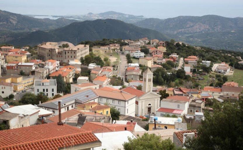
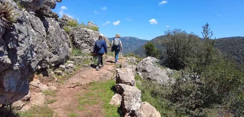
The inhabited centre of Tonara is dominated by its mountain and its beautiful woods, once consisting mainly of chestnut groves interspersed with small allotments. You set off directly from the centre of the village, parking next to the Town Hall and heading for the birthplace of the poet Peppino Mereu, a Tonaraian and a pride of the island. From here, walk along Via XX Settembre, Via Angioy and then Via Galusé, which leads to the spring of the same name, exulted about by the local poet. You are at the very edge of the village and from the spring begins a concreted road that threads its way through allotments, shaded by chestnut trees and orchards.

Gli orti - The Allotments 

As in all centres of the interior, the belt of allotments embraced the village but in Tonara, given the steepness of the slopes, these were terraced and supported by drystone walls. You stay on the main road with with gentle slopes, continuing even when it becomes a dirt road under a dense forest. After passing a small ford, at the first fork you come to, take a steep left onto a country lane surrounded by drystone walls, then left again at the next three-way fork. In this last stretch, one proceeds surrounded by chestnut groves that, although today in partial abandonment, constitute an invaluable richness of these mountains. 

Nel Bosco - In the woods 

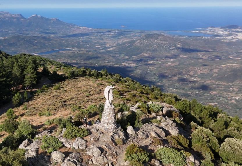
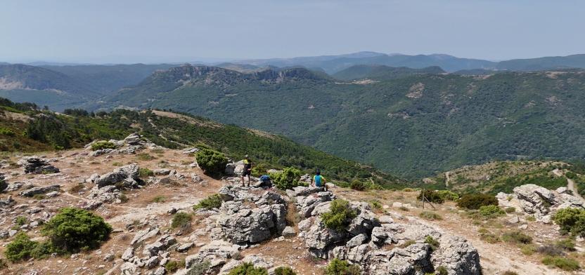
The last crossroads leads to a hidden cart track deep in the forest. You immediately pass by a water deposit and then continue with sudden uphill bends where, at times, the vegetation opens up, allowing wide panoramic views to the west. The strenuous climb is always well shaded and you soon come to three forks in quick succession, where you first take a left, then the second left and finally a right uphill, onto a pleasant dirt track at Morturasà. Here you turn left, slightly downhill. 

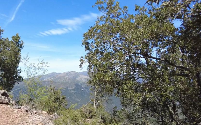
I Castagneti - The chestnut groves 

The dirt track that you follow is perfectly maintained and keeps to the edge of a vast area of reforestation. Soon, however, the cedars and black larch pines are replaced by the main attraction of this mountain: the chestnut. The beautiful open woodland, in which there are some large statuesque specimens, tells of the importance of forestry for these communities. You pass by a spring, which dries up in the summer season, and quickly reach an asphalt road: taking a left downhill, you quickly return to the village, however it is possible to turn right at the next crossroads to visit the spring of Funtana 'e s'Abe, with its fresh and wonderful ambience in all seasons, ideal for refreshment after the long walk before returning, through the narrow streets of the centre, to the car.

Itinerary roadbook

Lenght 4.700 m

-tonara-i-boschi-le-strade-dei-castagni.gpx

Total elevation gain 296 metri

Geographical area Barbagia

Aritzo, Texile. The natural monument

Itinerary

Access 

You commence the walk from the centre of Aritzo by taking Via Garibaldi, easily reached in the lower part of the village, then turning left once you reach the small panoramic square of Sant'Antonio, from which you can clearly distinguish the rocky taccu of Texile on the other side of the valley, the destination of the excursion. You continue down a narrow lane that leaves the last houses behind, immediumtely entering terraced allotments, dense hazelnut groves and tall walnut trees, splendid in autumn for their intense foliage.

The springs 

The descent is interrupted at an opening near the Giaria spring. Here, the route continues initially slightly uphill and on a sometimes concreted road always in a beautiful wooded environment despite its proximity to the village. In addition, to the essences already observed, there are dense holly trees and splendid specimens of chestnut and alder. You come to a fork where you turn right, slightly downhill on a cobbled road, following the signs for the Funtana de Zia Albara. Another stretch through hazel groves and terraced allotments separates this junction from the beautiful spring. Take a right here, also meeting the signs for Texile. Gradually descend, first encountering a picnic area near which the monumental Addalcia pine, which unfortunately recently fell to the ground. At a ford, a last spring is finally encountered. 

Texile 

Once past the ford, the dirt road worsens slightly and begins to climb, making a wide hairpin bend but always remaining defined. Ignore minor detours occasionally encountering some signs for Texile and keeping to the south-west direction until one can clearly distinguish the limestone peak above, which is reached at the top of the ascent. The geological peculiarity of Texile is that, similar to many taccos in Ogliastra and the Barbagia di Belvì and Seulo, it is completely isolated from similar rocks and is an island completely unique to its surroundings, consisting as it does of limestone and resting on Palaeozoic schists. This has allowed a rare and peculiar flora to vegetate only on its walls, making Texile a treasure chest of biodiversity, which has therefore become an SCI area (Site of Community Importance) and strictly protected. For the more intrepid, a rocky gully allows access to the summit, from which an extraordinary view of Aritzo, Belvì, the Gennargentu peaks and the Uatzo valley can be admired. On the summit of the peak one can also find numerous ceramics from the proto-historic period, which testifies to ancient settlements or places of worship on the mountain. After a long panoramic rest, you finally return to the village by the same route as the outward journey.

Lenght 7.800 m

aritzo.gpx

Total elevation gain 420 metri

Atzara, Su Caminu ‘e i’Bingias. In the ancient landscape of wine

Access 

This simple cycle route starts from the centre of the village in Mandrolisai, known for its beautiful territory and above all for the very high quality of its grapes and wines. Together with Sorgono, it possesses the only Sardinian landscape registered in the national register of Historic Rural Landscapes (Pesaggi Rurali Storici) testifying to the very long tradition of wine-making in this area. Proceed along the main street of the village, the SS 128 here called Via Vittorio Emanuele, turning east towards the church of Sant'Antioco Martire and then left into Via Pertini. The road leaves the last houses of the village on the left, continuing along Via Molinu and then meets the signs for Funtana 'e Paule, now immersed in the fields. 

Between the fields 

You continue slightly downhill, encountering a small ford and then beginning to climb, keeping to the asphalt road. Soon you come to a fork in the road: here you keep to the left, always slightly uphill, surrounded by beautiful cork oaks and the first vineyards. Soon, the vineyards begin to alternate regularly with pastures and wooded areas, often occupied by cork oaks and dense scrubland, immersed in the silent landscape of this corner of Mandrolisai. At the end of a straight stretch, you come to a fork where you keep to the right. A little further on, near a slight descent after a bend to the right, you reach the rural church of Santa Maria 'e Susu. The small building was built in the Middle Ages and stands near the disappeared village of Leonissa (Leonisa or Laonisa) and the ancient path to Belvì, of which some parts you are walking on. 

The vineyards 

Immediately after the church, you come to a fork in the road: here you take a right, continuing downhill to the village, now surrounded by vineyards. It is possible, taking a right, to make an detour, albeit not used frequently, continuing on an asphalt road to the natural spring of Laonisa and from here turn right onto a dirt road, then right again along a little-trodden lane to an antenna, from where you return to the asphalt road. A little further on, turn left immediately after a carpentry shop, returning to the village via a lane through the countryside.

Lenght 4.100 m

Atzara.gpx

Total elevation gain 109 metri

Austis, Sa Crabarissa. The rock of legend

Access 

From the village, follow the signs for Sa Crabarissa, following Via Gramsci, which soon turns into a country lane. you leave the beautiful sanctuary of S. Antonio on the right, still on an asphalted road, descending slightly to an obvious fork where you turn left, still following the signs. 

Bortamelone 

The area is overlooked by the gentle prominence of Monte Bortamelone, recognisable by its impressive reforestation. The road runs between pastures and scrubland. On the left is the rock of Nodu Pertuntu, not signposted, with its characteristic perforated summit. You continue along the main road, surrounded by arbutus trees, until the asphalt ends and the road proceeds, unpaved, always in excellent condition and slightly downhill, and now very scenic. 

Sa Crabarissa 

You reach a wide dirt clearing, keeping Bortamelone behind you, and after parking, take a right onto an clear path that heads toward the soaring, elegant silhouette of Sa Crabarissa. This extraordinary natural monument owes its name to a legend: a woman from Cabras (a crabarissa) who fell in love with a shepherd from Austis who was in her village for transhumance. The two swore eternal love to each other, but when she went to visit him, she discovered that he was already married and had a family. The girl went back, but the terrible pain turned her into stone: her form still resembles that of a girl from Cabras in typical costume. The rock is set in an extraordinary environmental context and can be reached along the beautiful path, keeping to the left. 

Ring in the bush 

Continue along the path, with a little slope, spotting a fork on the right that, once taken, leads uphill to a small artificial lake. Here, turn right onto a dirt track, still keeping to the right and returning to the car in a short time.

Lenght 19.500 m

austis.gpx

Total elevation gain 511 metri

Belvì, Pitzu ‘e Pranu. Overlooking the valley

Access 

From the inhabited centre of Belvì, the excursion begins by reaching the square in front of the church and from here take Via Marconi, where you descend slightly downhill, then turning right along a country lane into the countryside, indicated by a wooden signpost that points the way to some domus de Janas. You continue downhill, embraced by thick hazel tree groves that clutter the small road. This was once an important cart-track, as indicated by the ancient paving and the care with which the dry-stone walls bordering it were built. 

Uphill 

You lose altitude until you reach a bridge that crosses a noisy stream, in the map as Riu Salasi. Looming over the area are the walls of Pitzu 'e Pranu, the destination of the itinerary, while to the right is the beautiful arched bridge of the railway along which the Trenino verde (The little green train) now travels. Having crossed the bridge, you keep to the right at the next fork and begin to climb rapidly between the various fenced allotments that occupy the valley. The cart-track is still very evident, albeit slightly more ruined: at the top of the climb you come out on asphalt, on the SP 61 bis. Here the cart track continued, but is now overgrown by brambles. 

Towards the summit 

You then turn left, travelling about 200 metres downhill on the main road and finding a dirt road that turns right, uphill, immediately meeting a fork with a wider dirt road where you turn right. You are now at altitude, skirting the walls of Pitzu 'e Pranu in a counter-clockwise direction. The road is flanked by some large wooden poles and has been built precisely on the geological discontinuity between the limestone that makes up the mountain above and the schists of the ancient basement on which one has walked so far. You flank some allotments and soon reach a crossroads with a paved road, where you take a left, uphill, surrounded by Holm oak forest. At the next hairpin bend, not far from the road, is a beautiful lime kiln, used for processing limestone. 

Pitzu ‘and Pranu 

A final uphill stretch leads to a windswept, very scenic saddle, where there is a large crossroads. Here, one turns left, uphill, entering the reforestation that occupies the summit of Pitzu 'e Pranu and on which an adventure park, now disused, was built. Vetta del taccu (limestone formation), as its name suggests, is occupied by a vast plateau where small depressions betray the presence of several chasms, attributable to the karstic nature of the area. At the highest point, you reach a Virgin Mary, statue located on the edge of the walls. Here one literally overlooks the village and the neighbouring village of Aritzo, letting one's gaze wander as far as the Gennargentu and the wide surrounding valleys. You return to the village along the path followed on the outward journey.

Lenght 5.900 m

belvi.gpx

Total elevation gain 269 metri