Start website main content

Results

Marmilla

La Marmilla è una subregione della Sardegna posta nella parte centro-meridionale della regione.

È delimitata ad est e a sud dal Campidano, a nord-ovest dal Monte Arci, a nord dalla Giara di Gesturi e dalla Giara di Serri, a est dal Flumini Mannu.

Il paesaggio è prevalentemente collinare e comprende la Giara, l'altopiano di Genoni ed il bacino del Rio Mannu. Le attività principali della zona sono l'agricoltura ed il turismo. Le coltivazioni sono prevalentemente di cereali, ma è diffusa anche la coltivazione delle fave.

Il turismo nella Marmilla può contare su vari beni ambientali, numerosi centri nuragici, opere architettoniche. Si segnalano in particolare:

  • la Giara di Gesturi ed il Parco Naturale Monte Arci, il Villaggio nuragico di Su Nuraxi a Barumini,
  • il nuraghe Cuccurada a Mogoro, il complesso di Genna Maria a Villanovaforru, la fortezza di Su Mulinu a Villanovafranca, il santuario nuragico di Santa Vittoria a Serri.
  • Opere architettoniche quali le chiese romaniche di  San Michele Arcangelo a Siddi, San Pietro a Villamar e San Giovanni Battista a Barumini
  • chiese parrocchiali gotiche di San Vito di Gergei, Santa Barbara a Genoni e Beata Vergine Immacolata a Barumini,
  • il Castello giudicale di Las Plassas, la casa cinquecentesca Zapata di Barumini, i portali delle dimore storiche di Simala, il museo 'sa corona arrubia' in territorio di Lunamatrona

(fonte: Wikipedia).

Fanno parte di questo territorio i comuni: Albagiara, Ales, Baressa, Barumini, Collinas, Curcuris, Furtei, Genuri, Gesturi, Gonnoscodina, Gonnostramatza, Las Plassas, Lunamatrona, Masullas, Mogoro, Morgongiori, Nureci, Pau, Pauli Arbarei, Pompu, Sanluri, Sardara, Segariu, Senis, Setzu, Siddi, Simala, Sini, Siris, Tuili, Turri, Ussaramanna, Villamar, Villanovaforru, Villanovafranca.
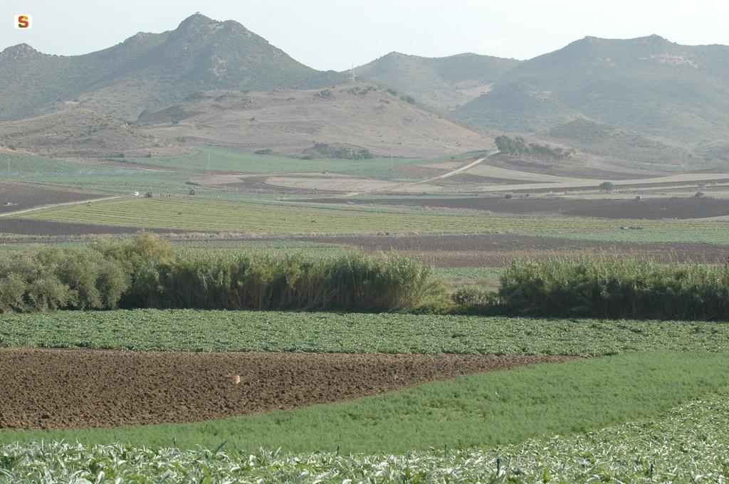
Marmilla is a sub-region of Sardinia located in the central-southern sector of the region. It is bordered to the east and the south by Campidano, to the north-west by Mount Arci, to the north by Giara di Gesturi and by Giara di Serri, and to the east by Flumini Mannu. The landscape is predominantly hilly and includes the Giara, the Genoni plateau and the Rio Mannu basin.   The main activities in this area are agriculture and tourism. The main crops are cereals, but broad bean cultivation is also widespread. Tourism in Marmilla can count on various environmental assets, numerous nuragic centres and architectural attractions.   Noteworthy attractions include:  Giara of Gesturi and the Mount Arci Natural Park, the Nuragic Village of Su Nuraxi in Barumini, nuraghe Cuccurada in Mogoro, the complex of Genna Maria in Villanovaforru, the fortress of Su Mulinu in Villanovafranca and the nuragic sanctuary of Santa Vittoria in Serri.  Architectural structures such as the Romanesque churches of San Michele Arcangelo in Siddi, San Pietro in Villamar and San Giovanni Battista in Barumini. the Gothic parish churches of San Vito di Gergei, Santa Barbara in Genoni and Beata Vergine Immacolata in Barumini, the Castle of Las Plassas, the 16th century Casa Zapata in Barumini, the entrance portals of the historical residences of Simala, the 'sa corona arrubia museum in Lunamatrona     [source: Wikipedia].

The area includes the municipalities of:  Albagiara, Ales, Baressa, Barumini, Collinas, Curcuris,  Furtei, Genuri, Gesturi, Gonnoscodina, Gonnostramatza, Las Plassas, Lunamatrona, Masullas, Mogoro, Morgongiori, Nureci, Pau, Pauli Arbarei, Pompu, Sanluri, Sardara,  Segariu, Senis, Setzu, Siddi, Simala, Sini, Siris, Tuili, Turri, Ussaramanna, Villamar, Villanovaforru, Villanovafranca.

437822.jpg
slug
marmilla

Sarrabus-Sette Fratelli

The area is located in the south-eastern sector of Sardinia, between the historical regions of Sarrabus and Campidano, and administratively speaking, lies within the municipalities of Burcei, Sinnai, San Vito, Dolianova, Settimo San Pietro, Soleminis, Castiadas and Muravera. 
The climate is typically Mediterranean, characteristic of the southern regions of Sardinia, with long, hot dry summers that last for about four months, while the winter is mild with moderate rainfall. The vegetation of the forest complex of Settefratelli is quite varied, with the coastal strip featuring typical Mediterranean maquis with mastic (Pistacia lentiscus L.), the Phoenician juniper (Juniperus phoenicea L.), tree spurge (Euphorbia dendroides L.), sporadic olive tree specimens (Olea europea L. var. sylvestris Brot.) 
and narrow-leaved mock privet (Phyllirea angustifolia L.), while in inland areas the most widespread forest species is the holm oak together with strawberry tree, broad-leaved phyllirea, heather and viburnum. Cork oaks are also found at medium-low elevations. 
Pulvinus vegetation characterises the highest ridges, with Corsican broom, thyme and lavender, with riparian vegetation along streams and rivers including oleander, willows and alder.   Especially in the State-owned forests of Settefratelli and Castiadas, the territory represents a natural habitat of Sardinian deer which have found a safe refuge here and are protected thanks to the conservation work of the Forestry Authority.   In addition to deer, the forests are home to numerous other animal species such as eagle, marten, Sardinian hare, wild boar, partridge and fox.
 

The area is located in the south-eastern sector of Sardinia, between the historical regions of Sarrabus and Campidano, and administratively speaking, lies within the municipalities of Burcei, Sinnai, San Vito, Dolianova, Settimo San Pietro, Soleminis, Castiadas and Muravera. 
The climate is typically Mediterranean, characteristic of the southern regions of Sardinia, with long, hot dry summers that last for about four months, while the winter is mild with moderate rainfall. The vegetation of the forest complex of Settefratelli is quite varied, with the coastal strip featuring typical Mediterranean maquis with mastic (Pistacia lentiscus L.), the Phoenician juniper (Juniperus phoenicea L.), tree spurge (Euphorbia dendroides L.), sporadic olive tree specimens (Olea europea L. var. sylvestris Brot.) 
and narrow-leaved mock privet (Phyllirea angustifolia L.), while in inland areas the most widespread forest species is the holm oak together with strawberry tree, broad-leaved phyllirea, heather and viburnum. Cork oaks are also found at medium-low elevations. 
Pulvinus vegetation characterises the highest ridges, with Corsican broom, thyme and lavender, with riparian vegetation along streams and rivers including oleander, willows and alder.   Especially in the State-owned forests of Settefratelli and Castiadas, the territory represents a natural habitat of Sardinian deer which have found a safe refuge here and are protected thanks to the conservation work of the Forestry Authority.   In addition to deer, the forests are home to numerous other animal species such as eagle, marten, Sardinian hare, wild boar, partridge and fox.
 

Galleria Immagini Media
bivio per maidopis.jpg
controlli Segnaletica prima della messa in posa.jpg
foto panoramica in loc. Acqueddas lungo sentiero vs aree sperimentali del Life ceduo.JPG
slug
sarrabus-sette-fratelli

Sarrabus-Sette Fratelli

Il territorio si trova nel settore sud-orientale della Sardegna, tra le regioni storiche del Sarrabus e del Campidano, ed è compreso, amministrativamente, nei territori dei Comuni di Burcei, Sinnai, San Vito, Dolianova, Settimo San Pietro, Soleminis, Castiadas e Muravera. 
Il clima è tipicamente mediterraneo, caratteristico delle zone meridionali sarde, con estati calde, lunghe ed asciutte che si protraggono per circa quattro mesi, mentre l’inverno è mite e moderatamente piovoso. 
La vegetazione del complesso forestale di Settefratelli è piuttosto varia presentandosi sulla fascia litoranea con la tipica macchia a lentischio (Pistacia lentiscus L.), col ginepro fenicio (Juniperus phoenicea L.) con l’euforbia arborea (Euphorbia dendroides L.), con sporadici esemplari diolivastro (Olea europea L. var. sylvestris Brot.) e con la fillirea angustifolia (Phyllirea angustifolia L.), mentre nelle aree interne la formazione forestale maggiormente diffusa è la lecceta associata a seconda delle situazioni al corbezzolo, alla fillirea latifoglia, all’erica e al viburno. A quote medio basse si trova anche la sughera. Sui crinali più alti si trova una vegetazione a pulvino con ginestra corsa, timo, lavanda, mente lungo gli alvei dei torrenti la vegetazione riparia a oleandro, salici e ontano.  Il territorio costituisce, soprattutto nelle Foreste Demaniali dei Settefratelli e di Castiadas, uno degli areali di eccellenza del cervo sardo che qui ha trovato rifugio ed è protetto e conservato grazie all’azione dell’Ente Foreste. 
Oltre al cervo, le foreste ospitano numerose altre specie animali come l’aquila, la martora, la lepre sarda, il cinghiale, la pernice e la volpe
 

The area is located in the south-eastern sector of Sardinia, between the historical regions of Sarrabus and Campidano, and administratively speaking, lies within the municipalities of Burcei, Sinnai, San Vito, Dolianova, Settimo San Pietro, Soleminis, Castiadas and Muravera. 
The climate is typically Mediterranean, characteristic of the southern regions of Sardinia, with long, hot dry summers that last for about four months, while the winter is mild with moderate rainfall. The vegetation of the forest complex of Settefratelli is quite varied, with the coastal strip featuring typical Mediterranean maquis with mastic (Pistacia lentiscus L.), the Phoenician juniper (Juniperus phoenicea L.), tree spurge (Euphorbia dendroides L.), sporadic olive tree specimens (Olea europea L. var. sylvestris Brot.) 
and narrow-leaved mock privet (Phyllirea angustifolia L.), while in inland areas the most widespread forest species is the holm oak together with strawberry tree, broad-leaved phyllirea, heather and viburnum. Cork oaks are also found at medium-low elevations. 
Pulvinus vegetation characterises the highest ridges, with Corsican broom, thyme and lavender, with riparian vegetation along streams and rivers including oleander, willows and alder.   Especially in the State-owned forests of Settefratelli and Castiadas, the territory represents a natural habitat of Sardinian deer which have found a safe refuge here and are protected thanks to the conservation work of the Forestry Authority.   In addition to deer, the forests are home to numerous other animal species such as eagle, marten, Sardinian hare, wild boar, partridge and fox.
 

Galleria Immagini Media
bivio per maidopis.jpg
controlli Segnaletica prima della messa in posa.jpg
foto panoramica in loc. Acqueddas lungo sentiero vs aree sperimentali del Life ceduo.JPG
slug
sarrabus-sette-fratelli

Gutturu Mannu

This area extends into the territories of Assemini, Pula, Santadi, Sarroch, Siliqua, Uta and Villa San Pietro in the Special Protection Zone ITB044009 and in the Site of Community Interest ITB001106 (Mount Arcosu Forest).
The Regional Nature Park of Gutturu Mannu is an area of great natural interest and includes the homonymous State-owned forest situated in the southern part of the province of Cagliari. 
The entire forest was included in the Sulcis Natural Park under regional law n. 31/89 considering extensive western territory of the Sardinian deer. Granite massifs of the Paleozoic with deformed morphology and an alternating sequence of valleys and plateaus.  Peaks over a thousand metres high. Abundance of holm oak woods with yews and hollies in the most isolated ravines; cork trees, strawberry trees, phillyrea arborescent and mastic. Mediterranean maquis with heather, arborescent strawberry tree.
With the approval of Regional Law n. 20 of 2014. 
The park covers the territories of the municipalities of Assemini, Pula, Santadi, Sarroch, Siliqua, Uta, Villa San Pietro, Domus de Maria, Capoterra and Teulada.
No less important from a faunistic point of view are the seasonal migrations of the Sardinian deer and wild boar. Also present are the fox, the Sardinian wild cat, the marten, the woodcock, the woodpigeon and red woodpeckers. Mining settlements (Pantaleo), archaeological settlements and settlements of ancient peasant culture. 
In addition, the S.I.C. area. I.T.B. 001105 -'Monte Arcosu Forest' covers approximately 70% of its area and most of the permanent wildlife reserve 'Gutturu Mannu - Monte Arcosu' in accordance with decrees n°102 of 20.07.78 and n°1240 of 15.11.88.

This area extends into the territories of Assemini, Pula, Santadi, Sarroch, Siliqua, Uta and Villa San Pietro in the Special Protection Zone ITB044009 and in the Site of Community Interest ITB001106 (Mount Arcosu Forest).
The Regional Nature Park of Gutturu Mannu is an area of great natural interest and includes the homonymous State-owned forest situated in the southern part of the province of Cagliari. 
The entire forest was included in the Sulcis Natural Park under regional law n. 31/89 considering extensive western territory of the Sardinian deer. Granite massifs of the Paleozoic with deformed morphology and an alternating sequence of valleys and plateaus.  Peaks over a thousand metres high. Abundance of holm oak woods with yews and hollies in the most isolated ravines; cork trees, strawberry trees, phillyrea arborescent and mastic. Mediterranean maquis with heather, arborescent strawberry tree.
With the approval of Regional Law n. 20 of 2014. 
The park covers the territories of the municipalities of Assemini, Pula, Santadi, Sarroch, Siliqua, Uta, Villa San Pietro, Domus de Maria, Capoterra and Teulada.
No less important from a faunistic point of view are the seasonal migrations of the Sardinian deer and wild boar. Also present are the fox, the Sardinian wild cat, the marten, the woodcock, the woodpigeon and red woodpeckers. Mining settlements (Pantaleo), archaeological settlements and settlements of ancient peasant culture. 
In addition, the S.I.C. area. I.T.B. 001105 -'Monte Arcosu Forest' covers approximately 70% of its area and most of the permanent wildlife reserve 'Gutturu Mannu - Monte Arcosu' in accordance with decrees n°102 of 20.07.78 and n°1240 of 15.11.88.

210 - La cresta sotto Monte Maxia_.jpg
slug
gutturu-mannu

Gutturu Mannu

L'area del Parco naturale regionale di Gutturu Mannu si estende nei territori di Pula, Villa San Pietro, Siliqua, Domus De Maria, Uta, Assemini, Santadi, Capoterra, Sarroch e Teulada, nella Zona di Protezione Speciale ITB044009 e nel Sito di Interesse Comunitario ITB001106 (Foresta di Monte Arcosu). Un territorio di elevato interesse naturalistico, comprende al suo interno la omonima Foresta Demaniale, situata nella parte sud della provincia di Cagliari. Altri importanti presidi forestali demaniali sono Pixinamanna, Is Cannoneris, Pantaleo e Monte Nieddu. Tutte le aree forestali sono comprese nel Parco naturale del Sulcis ai sensi della L.R. 31/89 per la presenza di: "esteso areale occidentale del cervo sardo"- "massicci granitici del Paleozoico dalla tormentata morfologia con valloni alternati a pianori" - "vette elevate oltre i mille metri". Ricchissimo di boschi di lecci con frequenza di tassi e agrifogli negli anfratti più remoti; sughere, corbezzoli, filliree arborescenti e lentischi.  Macchia mediterranea con erica e corbezzolo arborescente.

Importante sotto l’aspetto faunistico per le migrazioni stagionali del cervo sardo e del cinghiale. Presenti anche la volpe, il gatto selvatico sardo, la martora, la beccaccia, il colombaccio e picchi rossi.  "Insediamenti minerari (Pantaleo) e insediamenti archeologici e di antica cultura contadina".      Inoltre ricade nell’area S.I.C. I.T.B. 001105 –‘Foresta di Monte Arcosu’ per circa il 70% della sua superficie e (per gran parte) nell’ Oasi permanente di protezione faunistica ‘Gutturu Mannu - Monte Arcosu’ decretati nel 1978 e nel 1988.   In varie località (ad esempio: Is Fenebas, Is Antiogus...) si può usufruire delle aree pic-nic.

This area extends into the territories of Assemini, Pula, Santadi, Sarroch, Siliqua, Uta and Villa San Pietro in the Special Protection Zone ITB044009 and in the Site of Community Interest ITB001106 (Mount Arcosu Forest).
The Regional Nature Park of Gutturu Mannu is an area of great natural interest and includes the homonymous State-owned forest situated in the southern part of the province of Cagliari. 
The entire forest was included in the Sulcis Natural Park under regional law n. 31/89 considering extensive western territory of the Sardinian deer. Granite massifs of the Paleozoic with deformed morphology and an alternating sequence of valleys and plateaus.  Peaks over a thousand metres high. Abundance of holm oak woods with yews and hollies in the most isolated ravines; cork trees, strawberry trees, phillyrea arborescent and mastic. Mediterranean maquis with heather, arborescent strawberry tree.
With the approval of Regional Law n. 20 of 2014. 
The park covers the territories of the municipalities of Assemini, Pula, Santadi, Sarroch, Siliqua, Uta, Villa San Pietro, Domus de Maria, Capoterra and Teulada.
No less important from a faunistic point of view are the seasonal migrations of the Sardinian deer and wild boar. Also present are the fox, the Sardinian wild cat, the marten, the woodcock, the woodpigeon and red woodpeckers. Mining settlements (Pantaleo), archaeological settlements and settlements of ancient peasant culture. 
In addition, the S.I.C. area. I.T.B. 001105 -'Monte Arcosu Forest' covers approximately 70% of its area and most of the permanent wildlife reserve 'Gutturu Mannu - Monte Arcosu' in accordance with decrees n°102 of 20.07.78 and n°1240 of 15.11.88.

210 - La cresta sotto Monte Maxia_.jpg
slug
gutturu-mannu

In verifica o Manutenzione

Valore numerico
3
Classe colore stato
is-revisioning

In revisione-validazione

Valore numerico
2
Classe colore stato
is-revisioning

Not walkable/not open

Valore numerico
1
Classe colore stato
is-unvalidated

Non percorribile

Valore numerico
1
Classe colore stato
is-unvalidated