Start website main content

Horse

48 pathways

Ippovia è un itinerario percorribile a cavallo, raramente asfaltato, che attraversa riserve naturali, boschi, colline e vallate, talvolta costeggiando corsi d'acqua e spiagge, attraversando evidenze storiche-culturali o borghi. L'ippovia consente la pratica dell'equiturismo ma può anche essere percorsa a piedi.  Lungo il percorso si prevedono tappe, distanti non più di 20 km, dove cavaliere e cavallo possano trovare assistenza, ristoro ed eventuale pernottamento...

Ippoturismo.png

Results

Sentiero Italia (Stage SI Z12) Orosei - Dorgali

Overview of the itinerary

Sentiero Italia runs the length of the island’s eastern side, covering its most important mountains, in 28 stages.  Starting from the north: it flanks the Monte Limbara massif, crosses the limestones of Mont’Albo and Tuttavista, skirting the Gulf of Orosei, it crosses the Supramonte, Gennargentu and the Tacchi of Ogliastra and reaches Perdasdefogu.  Further south, it passes through Armungia and the Gerrei sub-region. Lastly, it touches on the villages of Burcei and San Gregorio, continuing on the Sette Fratelli massif to the old prisons of Castiadas.

General information on Sentiero Italia (Grand Italian Trail)

Sentiero Italia, or Grand Italian Trail, as also explained on the official website, is a walking route that crosses the whole of Italy, using mainly but not exclusively “registered trails”.   
In particular, in Sardinia, not all the stages of the Sentiero Italia of CAI (Italian Alpine Club) are made of trails already included in the registry of the Sardinia Trail Network (RES), either because they have not yet been tested and approved or simply because they cannot be registered as they do not meet the requirements.  However, as a whole, the Sentiero Italia is the single longest walking route currently crossing Sardinia from the north (S. Teresa Gallura, stage Z 1) to the south (Castiadas, end of stage Z 28), touching on the most fascinating mountain areas in central-eastern Sardinia: the plateau of Buddusò, Tepilora, the Cedrino river valley, the ancient forests of Montes, Perda Liana and the regional forest of Montarbu, Monte Genis, and lastly the regional forest of Settefratelli (among the many crossed by the various stages of this long hiking itinerary).

Information on this stage of the trail

The first part of this stage links the town of Orosei to its beach (‘marina’), along the recently restored right bank of the Cedrino river. The second stretch on flat ground heads south between the beach and the wetland, reaching the small beach of Osala, which marks the boundary of the territory of Orosei. Next, you will reach Cartoe beach by circling the headland of Punta Nera, following the rocky coast, in some places quite close to the sea which may present some difficulties. An alternative is to climb over the headland on an easily visible path, but which is mostly on private land. 

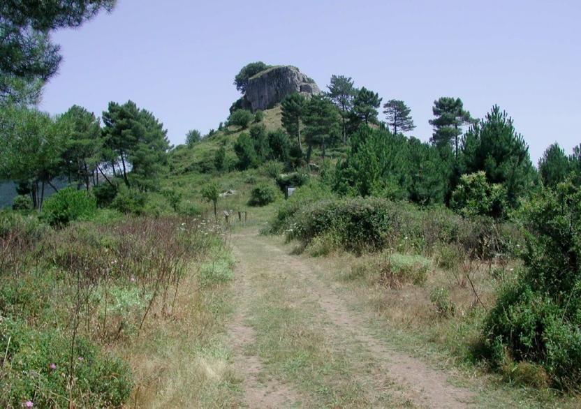
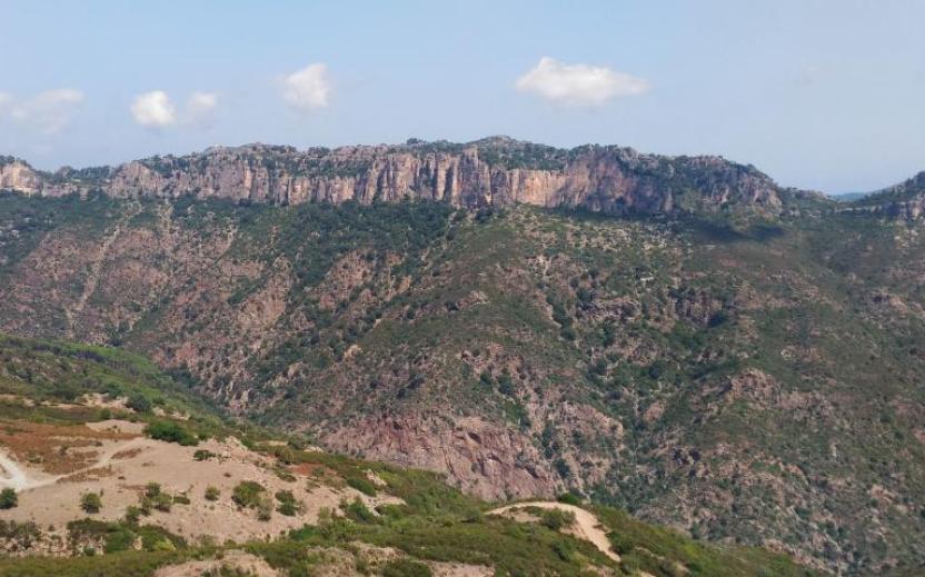
The south end of Cartoe beach marks the start of the third section of this stage, the more challenging one, which requires climbing the two peaks marked on the maps as Monte Irveri, 616 m asl, and Monte Bardia, 880 m asl, divided by a pass crossed by a paved road leading to the village of Cala Gonone. From Monte Bardia, which overlooks the town of Dorgali, you can descend quickly, along the ridge line, to the Buca Entu col. From here, a picturesque old mule track (Scala Omines) leads to a paved path that reaches the town of Dorgali

While this stage has no water sources, it offers wonderful panoramic views of the Gulf of Orosei as well as some recently restored old sheepfolds

Lenght 22.900 m

SI Z12.gpx

Total elevation gain 1 349 metri

Geographical area Baronie e Montalbo

Sentiero Italia (Tappa SI Z12) Orosei - Dorgali

In sintesi

Il Sentiero Italia attraversa in lunghezza il settore orientale dell’isola toccandone i sistemi montuosi più rilevanti, in 28 tappe.  Partendo da nord: tocca il massiccio del Monte Limbara, attraversa i calcari del Mont'Albo e del Tuttavista sfiorando il Golfo di Orosei,  attraversa il Supramonte, il Gennargentu, i Tacchi dell’Ogliastra e giunge a Perdasdefogu.  Più a sud, transita da Armungia e dalla subregione del Gerrei. Infine tocca l’abitato di Burcei e San Gregorio, per continuare nel massiccio dei Sette Fratelli fino alle vecchie carceri di Castiadas.

Informazioni generali sull'itinerario sentiero Italia

Il Sentiero Italia, come spiegato anche nel sito ufficiale, è un itinerario (o Cammino) lungo tutta l'Italia, che utilizza prevalentemente ma non esclusivamente "sentieri accatastati".   
In particolare, in Sardegna, non tutte le tappe del Sentiero Italia del CAI coincidono con sentieri già inseriti nel catasto della Rete Escursionistica della Sardegna (RES), perché non hanno ancora superato le verifiche di percorribilità oppure semplicemente perché non possono essere accatastati non avendone i requisiti.  Tuttavia, nel suo insieme, il Sentiero Italia rappresenta l'unica, la più grande dorsale escursionistica che attraversa attualmente la nostra Isola da nord (S. Teresa Gallura, tappa Z 1) a sud (Castiadas, fine tappa Z 28) toccando le aree montane della Sardegna centro-Orientale più affascinanti: l'altopiano di Buddusò, Tepilora, la valle del Cedrino, i boschi vetusti di Montes, Perda Liana e la foresta demaniale di Montarbu, il Monte Genis, e infine la foresta demaniale di Settefratelli (tra le tante attraversate dal lungo itinerario escursionistico a tappe).

Info sul percorso di questa tappa

Tappa caratterizzata da un prima parte che collega il centro abitato di Orosei con la marina percorrendo l’argine destro, recentemente sistemato, del fiume Cedrino, seguita da una seconda parte sempre pianeggiante in direzione sud, che attraversa tutto l’arenile, tra lo stesso e lo stagno, fino alla spiaggetta di Osala, limite amministrativo di Orosei. Da qui si raggiunge la spiaggia successiva di Cartoe contornando il promontorio di Punta Nera praticamente sugli scogli, in alcun punti rasentando l’acqua che talvolta potrebbe condizionare il passaggio. Un’alternativa consiste nel superare il promontorio scollinando con un percorso facilmente intuibile ma che insiste per buona parte in una proprietà privata. 

Dal limite sud della spiaggia di Cartoe inizia la terza parte del percorso, quella più impegnativa, che richiede il superamento dei due rilievi segnati sulle carte come Monte Irveri, 616 slm, e Monte Bardia, 880 slm, separati da un valico con strada cementata che conduce al centro di Cala Gonone. Da Monte Bardia, che domina l’abitato di Dorgali, si scende rapidamente, sul filo di cresta, fino alla sella di Buca Entu e da qui, con una suggestiva e antica mulattiera (Scala Omines) si raggiunge un vialetto lastricato che arriva fino al paese di Dorgali

Da segnalare la mancanza di sorgenti per approvvigionamento idrico, mancanza compensata da stupendi e continui panorami sul Golfo di Orosei e dalla possibilità di apprezzare alcuni antichi insediamenti pastorali recentemente ristrutturati.

Note

Nota del 25/02/2022. Si segnala la momentanea inagibilità del ponticello che supera l'uscita a mare dello stagno retrodunale di su Barone di Orosei. Per aggirare la problematica, prendere il passaggio sullo stagno prima del molo di Marina di Orosei, seguire la strada verso l’entroterra fino a quando si arriva ad un incrocio. Qui seguire l’insegna “Su Barone”, proseguire su strada asfalta e rientrare sul percorso originale dopo aver riattraversato lo stagno.
 

Informazioni utili

Lungo il percorso non sarà sempre presente la copertura telefonica

Lenght 22.900 m

SI Z12.gpx

Total elevation gain 1 349 metri

Geographical area Baronie e Montalbo

Sentiero Italia (Stage Z24) Cuile Is Arrantas - Armungia

Overview of the itinerary

Sentiero Italia runs the length of the island’s eastern side, covering its most important mountains, in 28 stages.  Starting from the north: it flanks the Monte Limbara massif, crosses the limestones of Mont’Albo and Tuttavista, skirting the Gulf of Orosei, it crosses the Supramonte, Gennargentu and the Tacchi of Ogliastra and reaches Perdasdefogu.  Further south, it passes through Armungia and the Gerrei sub-region. Lastly, it touches on the villages of Burcei and San Gregorio, continuing on the Sette Fratelli massif to the old prisons of Castiadas.

General information on Sentiero Italia (Grand Italian Trail)

Sentiero Italia, or Grand Italian Trail, as also explained on the official website, is a walking route that crosses the whole of Italy, using mainly but not exclusively “registered trails”.   
In particular, in Sardinia, not all the stages of the Sentiero Italia of CAI (Italian Alpine Club) are made of trails already included in the registry of the Sardinia Trail Network (RES), either because they have not yet been tested and approved or simply because they cannot be registered as they do not meet the requirements.  However, as a whole, the Sentiero Italia is the single longest walking route currently crossing Sardinia from the north (S. Teresa Gallura, stage Z 1) to the south (Castiadas, end of stage Z 28), touching on the most fascinating mountain areas in central-eastern Sardinia: the plateau of Buddusò, Tepilora, the Cedrino river valley, the ancient forests of Montes, Perda Liana and the regional forest of Montarbu, Monte Genis, and lastly the regional forest of Settefratelli (among the many crossed by the various stages of this long hiking itinerary).

Information on this stage of the trail

From Escalaplano, following paved and dirt tracks, this is a 20-km stage, first heading towards Marcasua, then following the Rio Su Ruaxiu stream and the Sentiero dei Carbonai (charcoal burners’ path) to the Sa Mola plateau with its characteristic rocks shaped by the elements. 

The route then descends into the Flumendosa valley and ends in Armungia, the home town of writer and politician Emilio Lussu

Don’t miss the nuraghe (prehistoric stone fortress) in the centre of Armungia dating back to the Bronze Age, around 1500-1400 BC.

Lenght 23.200 m

SI Z24.gpx

Total elevation gain 915 metri

Geographical area Gerrei Sarrabus-Sette Fratelli

Sentiero Italia (Tappa Z24) Cuile Is Arrantas - Armungia

In sintesi

Il Sentiero Italia attraversa in lunghezza il settore orientale dell’isola toccandone i sistemi montuosi più rilevanti, in 28 tappe.  Partendo da nord: tocca il massiccio del Monte Limbara, attraversa i calcari del Mont'Albo e del Tuttavista sfiorando il Golfo di Orosei,  attraversa il Supramonte, il Gennargentu, i Tacchi dell’Ogliastra e giunge a Perdasdefogu.  Più a sud, transita da Armungia e dalla subregione del Gerrei. Infine tocca l’abitato di Burcei e San Gregorio, per continuare nel massiccio dei Sette Fratelli fino alle vecchie carceri di Castiadas.

Informazioni generali sull'itinerario sentiero Italia

Il Sentiero Italia, come spiegato anche nel sito ufficiale, è un itinerario (o Cammino) lungo tutta l'Italia, che utilizza prevalentemente ma non esclusivamente "sentieri accatastati".   
In particolare, in Sardegna, non tutte le tappe del Sentiero Italia del CAI coincidono con sentieri già inseriti nel catasto della Rete Escursionistica della Sardegna (RES), perché non hanno ancora superato le verifiche di percorribilità oppure semplicemente perché non possono essere accatastati non avendone i requisiti.  Tuttavia, nel suo insieme, il Sentiero Italia rappresenta l'unica, la più grande dorsale escursionistica che attraversa attualmente la nostra Isola da nord (S. Teresa Gallura, tappa Z 1) a sud (Castiadas, fine tappa Z 28) toccando le aree montane della Sardegna centro-Orientale più affascinanti: l'altopiano di Buddusò, Tepilora, la valle del Cedrino, i boschi vetusti di Montes, Perda Liana e la foresta demaniale di Montarbu, il Monte Genis, e infine la foresta demaniale di Settefratelli (tra le tante attraversate dal lungo itinerario escursionistico a tappe).

Info sul percorso di questa tappa

Da Escalaplano per carrarecce asfaltate e bianche, una tappa di una ventina di chilometri dapprima verso Marcasua, poi lungo il torrente Rio Su Ruaxiu e il sentiero dei carbonai fino all’altipiano di Sa Mola con le sue caratteristiche rocce modellate dagli agenti atmosferici. 

Si scende nella valle del Flumendosa e si conclude ad Armungia, il paese che diede i natali al grande scrittore e politico Emilio Lussu

Di particolare interesse il nuraghe che sorge proprio al centro di Armungia risalente all’età del bronzo, circa 1500-1400 a. C..


Informazioni utili

Lungo il percorso non sarà sempre presente la copertura telefonica

Lenght 23.200 m

SI Z24.gpx

Total elevation gain 915 metri

Geographical area Gerrei Sarrabus-Sette Fratelli