Accessible trails
Sentieri per tutti...in questa categoria rientrano i sentieri progettati o riadattati perchè il contatto con l'ambiente naturale sia sempre di stimolo al miglioramento della vita personale di chiunque, con attenzione alle condizioni di disabilità motoria, sensoriale o della sfera psichica e relazionale...

Image credits Sardegna Digital Library Regione Sardegna
Results

Nuraghe Nolza - Meana Sardo
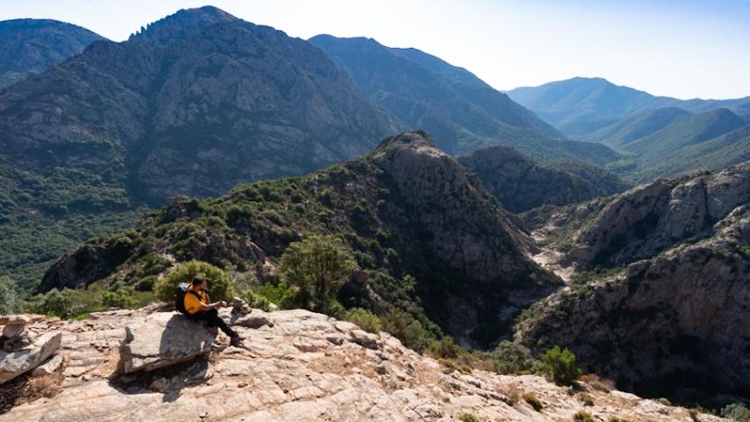
The village of Meana Sardo is located on a hill at an altitude of 600 m and the main attraction of the itinerary, the Nolza Nuraghe, on another hill at an altitude of 720 m. The two hills are separated by the Gunnarella gorge, at an altitude of 460 m. As a result, whichever way you go along the itinerary, there will always be two very steep climbs to exit the Gunnarella gorge. For a few hundred metres you will have to push on foot, unless you are very strong or have an electric bike. Proceeding clock-wise, the Nolza nuraghe is located at km 6 and with its 13 m high central tower is worth a visit (best booked in advance), with local guides constantly manning it. Other attractions along the route are a long road bordered by two dry stone walls and the mountain vineyards that for generations have testi-fied to working in harmony with nature.
Informazioni utili
The LEADER Territory of the Local Action Group (GAL) Rural District Barbagia Mandrolisai Gennargentu (BMG)
Consisting of the Union of Municipalities of Barbagia and the Mountain Community of Gennargentu Mandrolisai. The GAL BMG, therefore, includes 19 municipalities, with a total area of 854.30 sq km and a resident population of approximately 22,000 inhabitants: Aritzo, Atzara, Austis, Belvì, Desulo, Gadoni, Gavoi, Lodine, Meana Sardo, Ollolai, Oniferi, Olzai, Ortueri, Ovodda, Sarule, Sorgono, Teti, Tiana, Tonara.
The GAL Rural District BMG, established in 2009, is a participation foundation composed of 22 public members and over 200 private members, representing the main institutional, economic, and social components of the territory. The foundation aims to improve the quality of life and well-being of communities in the historical regions of Barbagia, Mandrolisai, and Gennargentu by enhancing local resources. The main thematic and intervention areas identified by the GAL BMG for the definition of its Local Development Strategy 2014-2022 are the development and innovation of local production chains and systems, social inclusion, and sustainable tourism.
THE OAST PROJECT: OUTDOOR ACTIVITIES FOR SUSTAINABLE TOURISM
The project, coordinated by the GAL BMG in partnership with the GAL Sisteron-Buëch (France) and the GAL Kilkenny (Ireland), aims to promote sustainable and active tourism in rural areas of Europe. The specific objective of the project was to enhance and develop the tourist attractiveness of the inland waters of Barbagia, through outdoor sports and water activities, in line with the thematic area "sustainable tourism" chosen in the GAL BMG's PDA. The three territories involved boast a rich and varied natural, landscape, and cultural heritage with strong identity traits and enormous potential for the development of active tourism. However, some problems common to all partners have been highlighted, such as: insufficient enhancement and tourist promotion of inland areas, isolation, the absence of an international network useful for the exchange of good practices, and insufficient diversification, delocalization, deseasonalization, and internationalization of tourist flows. The OAST Project was created to respond to these critical issues, as active tourism and sustainable tourism represent the basis for the revival of territories characterized by enormous problems of depopulation, lack of services, unemployment, and school dropout. The idea, therefore, is to promote forms of sustainable, active, responsible, and experiential tourism, as well as to offer diversified and deseasonalized solutions suitable for a constantly growing number of active tourists. The specific action involved the georeferencing and description, in Italian and English, of 19 GAL BMG itineraries related to the theme of water. The itinerary tracks are available and downloadable, in Gpx format, on these pages and also on the GAL BMG's Wikiloc account.
Tipologia itinerario
- Log in to post comments
Photogallery
Contiene carte
Spento
Nuraghe Nolza - Meana Sardo
AVVERTENZE
QUESTO ITINERARIO è riportato "tal quale" a titolo informativo e di mera recensione/ricognizione degli itinerari presenti nel territorio - come fornito e recensito dal progetto OAST condotto dal GAL BMG nel 2024.
NOTA: Molti itinerari sono composti da percorsi stretti e richiedono una cura periodica della vegetazione, al momento non assicurata da una gestione di tipo ufficiale, non essendo il tracciato inserito nella"rete escursionistica della Sardegna".
Nota 2: Prima di recarvi sul posto si consiglia di raccogliere informazioni sullo stato di fruibilità, presso il comune competente, per avere certezza dell'effettiva percorribilità dell'itinerario scelto.
IL PERCORSO IN PILLOLE (elementi informativi essenziali)
Il punto di partenza si trova nella strada principale di Meana Sardo, via Roma, all’altezza della chiesa di San Bartolomeo (di fronte al civico 76), che è anche la Strada Statale 128. Il senso di percorrenza è indifferente, qui viene descritto in senso orario.
Descrizione
Il paese di Meana Sardo si trova su un colle a 600 m di quota e la principale attrattiva dell’itinerario, ossia il nuraghe Nolza, su un altro colle a 720 m di quota. I due rilievi sono separati dalla gola del rio Gunnarella, a 460 m di quota, e ne deriva che in qualunque senso percorriate l’itinerario, ci saranno sempre due salite molto ripide per uscire dal canale del Gunnarella. Occorre esserne consapevoli e mettersi l’anima in pace: per qualche centinaio di metri occorrerà spingere a piedi (sul manubrio, non certo bici in spalla), a meno che non siate molto forti o abbiate una mtb elettrica. Procedendo in senso orario, il nuraghe Nolza si trova al km 6 ed è una bella attrattiva storica, con i suoi 13 m di altezza della torre centrale che merita una visita con le guide locali (meglio prenotare). È costantemente presidiato, perciò è anche una risorsa in caso di bisogno. Attenzione al cane del nuraghe, perché è appassionato nell’accompagnamento dei turisti, quindi, come ha fatto con me, potrebbe seguirvi in tutto l’itinerario fino al ritorno in paese. Il percorso è una sintesi di valori naturalistici e storici: tra questi ultimi, oltre al nuraghe, ammirerete una lunga strada delimitata tra due muretti a secco (opportuno lo sfalcio dell’erba che la occupa interamente) e le vigne di montagna che da generazioni testimoniano il lavoro in armonia con la natura.
Camminabilità
Il territorio e l’itinerario si prestano egregiamente anche al trekking, tanto più che a piedi le due salite citate nella descrizione hanno un peso minore. Se il chilometraggio e/o il dislivello fossero eccessivi per un solo giorno, il cammino può essere facilmente diviso in due parti, senza neanche la necessità di portarsi la tenda. Al km 10, nella zona del rimboschimento di pini, si trova un ottimo rifugio, costituito da una casetta in pietra col camino e un’altra, ugualmente col camino, si trova a meno di 1 km sul colle di Corte ‘e Cerbos. Come per tutte le casette in montagna, valgono sempre le regole di tenere pulito, di chiudere bene prima di andare via e di lasciare all’interno una buona scorta di legna, sia fine che grossa.
Informazioni utili
Il territorio LEADER del Gruppo di Azione Locale (GAL) Distretto Rurale Barbagia Mandrolisai Gennargentu (BMG)
Costituito dall'Unione dei Comuni Barbagia e dalla Comunità Montana Gennargentu Mandrolisai. Il GAL BMG comprende, quindi, 19 comuni, per una superficie complessiva di 854,30 kmq e una popolazione residente pari a circa 22.000 abitanti:
Aritzo, Atzara, Austis, Belvì, Desulo, Gadoni, Gavoi, Lodine, Meana Sardo, Ollolai, Oniferi, Olzai, Ortueri, Ovodda, Sarule, Sorgono, Teti, Tiana, Tonara.
Il GAL Distretto Rurale BMG, costituito nel 2009, è una Fondazione di partecipazione composta da 22 soci pubblici e oltre 200 privati, rappresentativi delle principali componenti istituzionali, economiche e sociali del territorio. La fondazione ha lo scopo di migliorare la qualità della vita e il benessere delle comunità nelle regioni storiche Barbagia, Mandrolisai e Gennargentu mediante la valorizzazione delle risorse locali.
I principali ambiti tematici e di intervento individuati dal GAL BMG per la definizione della propria Strategia di Sviluppo Locale 2014-2022 sono lo sviluppo e l’innovazione delle filiere e dei sistemi produttivi locali, l’inclusione sociale ed il turismo sostenibile.
IL PROGETTO OAST: OUTDOOR ACTIVITIES FOR SUSTAINABLE TOURISM
Il progetto, coordinato dal GAL BMG in partenariato con il GAL Sisteron-Buëch (Francese) e
il GAL Kilkenny (Irelanda), intende promuovere un turismo sostenibile e attivo nelle aree
rurali d’Europa.
L’obiettivo specifico del progetto è stato potenziare e sviluppare l’attrattività turistica delle acque
interne della Barbagia, attraverso gli sport all’aria aperta e le attività acquatiche, in coerenza con l’ambito tematico “turismo sostenibile” prescelto nel PDA del GAL BMG.
I tre territori coinvolti vantano un patrimonio naturalistico, paesaggistico e culturale ricco e variegato con forti caratteri identitari ed enormi potenzialità di sviluppo di turismo attivo.
Tuttavia, sono stati evidenziati alcuni problemi comuni a tutti i partner, quali: l’insufficiente valorizzazione e promozione turistica delle aree interne, l’isolamento, l’assenza di un network internazionale utile per lo scambio di buone prassi, e l’insufficiente diversificazione, delocalizzazione, destagionalizzazione e l’internazionalizzazione dei flussi turistici. Il Progetto OAST nasce per rispondere a queste criticità, in quanto il turismo attivo ed il turismo sostenibile rappresentano la base di rilancio dei territori caratterizzati da enormi problemi di spopolamento, carenza di servizi, disoccupazione e dispersione scolastica.
L’idea, quindi è promuovere forme di turismo sostenibile, attivo, responsabile ed esperienziale, nonché
offrire soluzioni diversificate e destagionalizzate adatte ad un numero di turisti attivi in continua crescita.
L’azione specifica ha previsto la georeferenziazione e descrizione, in lingua italiana e inglese, di
19 itinerari del GAL BMG legati al tema dell’acqua. Le tracce degli itinerari sono disponibili e scaricabili, in formato Gpx, in queste pagine e anche nell’account Wikiloc del GAL BMG
Tipologia itinerario
- Log in to post comments
Photogallery
Contiene carte
Spento
Sentiero Italia (Stage Z24) Cuile Is Arrantas - Armungia
Overview of the itinerary
Sentiero Italia runs the length of the island’s eastern side, covering its most important mountains, in 28 stages. Starting from the north: it flanks the Monte Limbara massif, crosses the limestones of Mont’Albo and Tuttavista, skirting the Gulf of Orosei, it crosses the Supramonte, Gennargentu and the Tacchi of Ogliastra and reaches Perdasdefogu. Further south, it passes through Armungia and the Gerrei sub-region. Lastly, it touches on the villages of Burcei and San Gregorio, continuing on the Sette Fratelli massif to the old prisons of Castiadas.
General information on Sentiero Italia (Grand Italian Trail)
Sentiero Italia, or Grand Italian Trail, as also explained on the official website, is a walking route that crosses the whole of Italy, using mainly but not exclusively “registered trails”.
In particular, in Sardinia, not all the stages of the Sentiero Italia of CAI (Italian Alpine Club) are made of trails already included in the registry of the Sardinia Trail Network (RES), either because they have not yet been tested and approved or simply because they cannot be registered as they do not meet the requirements. However, as a whole, the Sentiero Italia is the single longest walking route currently crossing Sardinia from the north (S. Teresa Gallura, stage Z 1) to the south (Castiadas, end of stage Z 28), touching on the most fascinating mountain areas in central-eastern Sardinia: the plateau of Buddusò, Tepilora, the Cedrino river valley, the ancient forests of Montes, Perda Liana and the regional forest of Montarbu, Monte Genis, and lastly the regional forest of Settefratelli (among the many crossed by the various stages of this long hiking itinerary).
Information on this stage of the trail
From Escalaplano, following paved and dirt tracks, this is a 20-km stage, first heading towards Marcasua, then following the Rio Su Ruaxiu stream and the Sentiero dei Carbonai (charcoal burners’ path) to the Sa Mola plateau with its characteristic rocks shaped by the elements.
The route then descends into the Flumendosa valley and ends in Armungia, the home town of writer and politician Emilio Lussu.
Don’t miss the nuraghe (prehistoric stone fortress) in the centre of Armungia dating back to the Bronze Age, around 1500-1400 BC.
Informazioni utili
Tipologia itinerario
- Log in to post comments
Photogallery
La valle del Flumendosa.jpg
L'alta valle del Flumendosa.jpg
Scorcio del Flumendosa.jpg
Armungia.-Caratteristiche-conformazioni-rocciose.jpg
Armungia.-Il-nuraghe-XIV-sec.-a.C.-ca.-al-centro-del-paese.jpg
Armungia.-Veduta-sulla-valle-del-Flumendosa-e-sui-resti-di-un-nuraghe-dal-percorso-del-Sentiero-Italia.jpg
Armungia.-Museo-etnografico-Sa-Domu-de-is-Ainas.jpg
Belvedere di Su Pardu visto da Armungia.jpg
Panorama su Armungia.jpg
Sentiero Italia (Tappa Z24) Cuile Is Arrantas - Armungia
In sintesi
Il Sentiero Italia attraversa in lunghezza il settore orientale dell’isola toccandone i sistemi montuosi più rilevanti, in 28 tappe. Partendo da nord: tocca il massiccio del Monte Limbara, attraversa i calcari del Mont'Albo e del Tuttavista sfiorando il Golfo di Orosei, attraversa il Supramonte, il Gennargentu, i Tacchi dell’Ogliastra e giunge a Perdasdefogu. Più a sud, transita da Armungia e dalla subregione del Gerrei. Infine tocca l’abitato di Burcei e San Gregorio, per continuare nel massiccio dei Sette Fratelli fino alle vecchie carceri di Castiadas.
Informazioni generali sull'itinerario sentiero Italia
Il Sentiero Italia, come spiegato anche nel sito ufficiale, è un itinerario (o Cammino) lungo tutta l'Italia, che utilizza prevalentemente ma non esclusivamente "sentieri accatastati".
In particolare, in Sardegna, non tutte le tappe del Sentiero Italia del CAI coincidono con sentieri già inseriti nel catasto della Rete Escursionistica della Sardegna (RES), perché non hanno ancora superato le verifiche di percorribilità oppure semplicemente perché non possono essere accatastati non avendone i requisiti. Tuttavia, nel suo insieme, il Sentiero Italia rappresenta l'unica, la più grande dorsale escursionistica che attraversa attualmente la nostra Isola da nord (S. Teresa Gallura, tappa Z 1) a sud (Castiadas, fine tappa Z 28) toccando le aree montane della Sardegna centro-Orientale più affascinanti: l'altopiano di Buddusò, Tepilora, la valle del Cedrino, i boschi vetusti di Montes, Perda Liana e la foresta demaniale di Montarbu, il Monte Genis, e infine la foresta demaniale di Settefratelli (tra le tante attraversate dal lungo itinerario escursionistico a tappe).
Info sul percorso di questa tappa
Da Escalaplano per carrarecce asfaltate e bianche, una tappa di una ventina di chilometri dapprima verso Marcasua, poi lungo il torrente Rio Su Ruaxiu e il sentiero dei carbonai fino all’altipiano di Sa Mola con le sue caratteristiche rocce modellate dagli agenti atmosferici.
Si scende nella valle del Flumendosa e si conclude ad Armungia, il paese che diede i natali al grande scrittore e politico Emilio Lussu.
Di particolare interesse il nuraghe che sorge proprio al centro di Armungia risalente all’età del bronzo, circa 1500-1400 a. C..
Informazioni utili
Lungo il percorso non sarà sempre presente la copertura telefonica
Tipologia itinerario
- Log in to post comments
Photogallery
La valle del Flumendosa.jpg
L'alta valle del Flumendosa.jpg
Scorcio del Flumendosa.jpg
Armungia.-Caratteristiche-conformazioni-rocciose.jpg
Armungia.-Il-nuraghe-XIV-sec.-a.C.-ca.-al-centro-del-paese.jpg
Armungia.-Veduta-sulla-valle-del-Flumendosa-e-sui-resti-di-un-nuraghe-dal-percorso-del-Sentiero-Italia.jpg
Armungia.-Museo-etnografico-Sa-Domu-de-is-Ainas.jpg
Belvedere di Su Pardu visto da Armungia.jpg
Panorama su Armungia.jpg
Pathways Correboi - Bruncu Spina (T 710)
CMSB - STAGE 06 – FROM PISCINAS TO MONTEVECCHIO
The stage is mostly uphill with an initial climb to reach the village of Ingurtosu.
You will discover some amazing examples of industrial archaeology in the disused mines of Ingurtosu and Montevecchio.
From the dune complex of Piscinas, you move on to the holm oak woods and to the Mediterranean scrub, where it is common to observe the Sardinian deer that populates this area.
Safety and useful tips
The stage does not present any particular difficulties, even though the route follows the SP04, which is an accessible dirt road.
In the first section, you have to cross twice the Rio Irvi, which flows alongside the road. If this watercourse is in flood and fording is not easy, it is advisable to take the main road, which in any case proceeds in the same direction as the route.
It is only when you reach the Church of Santa Barbara of Ingurtosu that you can take the SP04.18, an asphalted road where, despite the presence of few vehicles, you must pay attention when passing through, especially because of the turns that you find along the way. You will then reach the Management building after which you proceed following the SP 66, which is again a dirt road.
All along the way, you will come across several buildings dating back to the old mining activity, many of which are closed and secured; some others are not, but they are all in a state of disrepair and precarious stability. In order to avoid any problems or accidents, do not cross the fences and/or venture inside the ruined buildings of the old mining plants, but always admire them from a distance without leaving the Trail.
Informazioni utili
The stage presents a medium difficulty due to its mainly uphill development. The route has a length of 18.8 km, which can be covered in 6 hours and 30 minutes and has an altitude difference of 890 m uphill and downhill of 532 m.
FOR UPDATED INFORMATION, CONSULT THE STAGE SHEET ON THE OFFICIAL WEBSITE
Tipologia itinerario
- Log in to post comments
Links
Photogallery
Montevecchio, Pozzo Sartori.jpg
Montevecchio, cantiere Piccalinna Pozzo San Giovanni.jpg
Palazzina del direttore della miniera a Montevecchio.jpg
veduta della miniera di Montevecchio.jpg
Montevecchio, paesaggio.jpg
Ingurtosu, palazzo della Direzione (2).jpg
Ingurtosu, esemplari di cervo sardo.jpg
Ingurtosu, maschio adulto di cervo sardo.jpg
Ingurtosu, laveria Brassey - particolare.jpg
Ingurtosu, palazzo della Direzione.jpg
Ingurtosu, laveria Brassey.jpg
Piscinas. Arbus.jpg
tracciato-cammino-minerario-di-santa-barbara.jpg