Start website main content

Accessible trails

1 pathway

Sentieri per tutti...in questa categoria rientrano i sentieri progettati o riadattati perchè il contatto con l'ambiente naturale sia sempre di stimolo al miglioramento della vita personale di chiunque, con attenzione alle condizioni di disabilità motoria, sensoriale o della sfera psichica e relazionale...

Rio Ermolinos.jpg

Results

Sentiero Italia (Tappa Z27) Burcei – Valico Sette Fratelli

In sintesi

Il Sentiero Italia attraversa in lunghezza il settore orientale dell’isola toccandone i sistemi montuosi più rilevanti, in 28 tappe.  Partendo da nord: tocca il massiccio del Monte Limbara, attraversa i calcari del Mont'Albo e del Tuttavista sfiorando il Golfo di Orosei,  attraversa il Supramonte, il Gennargentu, i Tacchi dell’Ogliastra e giunge a Perdasdefogu.  Più a sud, transita da Armungia e dalla subregione del Gerrei. Infine tocca l’abitato di Burcei e San Gregorio, per continuare nel massiccio dei Sette Fratelli fino alle vecchie carceri di Castiadas.

Informazioni generali sull'itinerario sentiero Italia

Il Sentiero Italia, come spiegato anche nel sito ufficiale, è un itinerario (o Cammino) lungo tutta l'Italia, che utilizza prevalentemente ma non esclusivamente "sentieri accatastati".   
In particolare, in Sardegna, non tutte le tappe del Sentiero Italia del CAI coincidono con sentieri già inseriti nel catasto della Rete Escursionistica della Sardegna (RES), perché non hanno ancora superato le verifiche di percorribilità oppure semplicemente perché non possono essere accatastati non avendone i requisiti.  Tuttavia, nel suo insieme, il Sentiero Italia rappresenta l'unica, la più grande dorsale escursionistica che attraversa attualmente la nostra Isola da nord (S. Teresa Gallura, tappa Z 1) a sud (Castiadas, fine tappa Z 28) toccando le aree montane della Sardegna centro-Orientale più affascinanti: l'altopiano di Buddusò, Tepilora, la valle del Cedrino, i boschi vetusti di Montes, Perda Liana e la foresta demaniale di Montarbu, il Monte Genis, e infine la foresta demaniale di Settefratelli (tra le tante attraversate dal lungo itinerario escursionistico a tappe).

Info sul percorso di questa tappa

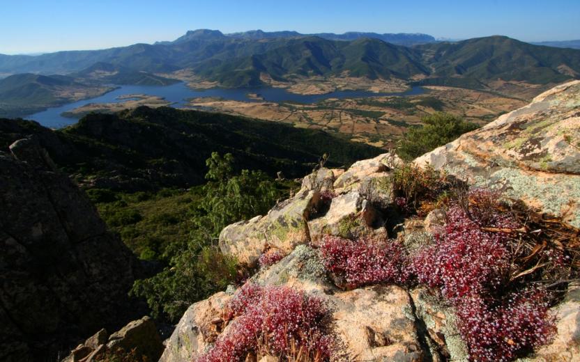
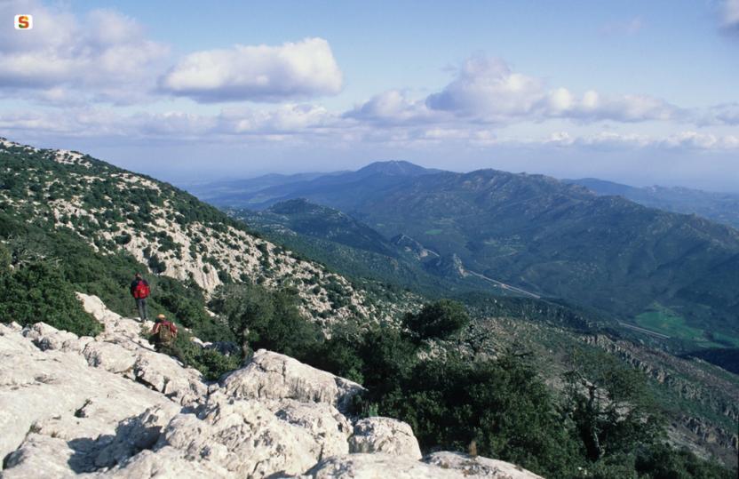
Dall’abitato di Burcei ci si avvia prevalentemente per strade bianche verso la cantoniera di Campu Omu da cui inizia il percorso verso i Sette Fratelli, l’ultimo massiccio montuoso che si incontrerà nella traversata dell’isola. 

Il territorio fa parte dell’omonimo parco che con diecimila ettari di foresta distesa sulle montagne è uno dei luoghi più verdi e affascinanti della Sardegna, una riserva naturale piena di piacevoli sorprese e panorami mozzafiato

L’arrivo è situato presso la caserma forestale di Campu Omu dopo una tappa di media difficoltà.

Informazioni utili

Lungo il percorso non sarà sempre presente la copertura telefonica

Lenght 13.700 m

SI Z27.gpx

Total elevation gain 828 metri

Geographical area Gerrei Sarrabus-Sette Fratelli

Sentiero Italia (Stage Z13) Dorgali - Sa Barva Loc. Surtana

Overview of the itinerary

Sentiero Italia runs the length of the island’s eastern side, covering its most important mountains, in 28 stages.  Starting from the north: it flanks the Monte Limbara massif, crosses the limestones of Mont’Albo and Tuttavista, skirting the Gulf of Orosei, it crosses the Supramonte, Gennargentu and the Tacchi of Ogliastra and reaches Perdasdefogu.  Further south, it passes through Armungia and the Gerrei sub-region. Lastly, it touches on the villages of Burcei and San Gregorio, continuing on the Sette Fratelli massif to the old prisons of Castiadas.

General information on Sentiero Italia (Grand Italian Trail)

Sentiero Italia, or Grand Italian Trail, as also explained on the official website, is a walking route that crosses the whole of Italy, using mainly but not exclusively “registered trails”.   
In particular, in Sardinia, not all the stages of the Sentiero Italia of CAI (Italian Alpine Club) are made of trails already included in the registry of the Sardinia Trail Network (RES), either because they have not yet been tested and approved or simply because they cannot be registered as they do not meet the requirements.  However, as a whole, the Sentiero Italia is the single longest walking route currently crossing Sardinia from the north (S. Teresa Gallura, stage Z 1) to the south (Castiadas, end of stage Z 28), touching on the most fascinating mountain areas in central-eastern Sardinia: the plateau of Buddusò, Tepilora, the Cedrino river valley, the ancient forests of Montes, Perda Liana and the regional forest of Montarbu, Monte Genis, and lastly the regional forest of Settefratelli (among the many crossed by the various stages of this long hiking itinerary).

Information on this stage of the trail

This stage begins by retracing your steps on the paved path, whence you came from Orosei, to the start point of the Iscala Omines, which you will leave on our left to continue towards the old tunnel built in 1863 to connect the town to the sea where the small town of Cala Gonone has since developed. 

After walking through the tunnel, you will reach the ridge of the mountain above state road SS 125. Follow a very scenic path in a south-southwesterly direction to the Suttaterra area, passing near a fascinating natural arch

A steep downhill stretch then leads to road SS 125 (Orientale Sarda) below, which you need to follow for about 550 m. Leaving the road, near the entrance to the Sa Pruna’ Forest, continue downhill, first on a dirt road and then on a well-maintained path, to reach and ford the Rio Flumineddu stream near the path leading to the Gorroppu gorge.

Continuing in a northerly direction and passing the turnoff for the S’Abba Arva bridge you will easily reach the stop point of SurtanaYou will find water in the Forest, at a spring along the route. Please note there are no permanent reception facilities at the Surtana stop point. We suggest booking logistical support with Mr Salvatore Fancello, aka Baddore, at 3470086640, owner of an accommodation facility about 800 m from Surtana. We also recommend the utmost caution when walking on the short stretch of the SS 125 road, which is a favourite road of motorcyclists, especially in spring and summer.

Lenght 19.200 m

SI Z13.gpx

Total elevation gain 858 metri

Geographical area Supramontes

Sentiero Italia (Tappa Z13) Dorgali - Sa Barva Loc. Surtana

In sintesi

Il Sentiero Italia attraversa in lunghezza il settore orientale dell’isola toccandone i sistemi montuosi più rilevanti, in 28 tappe.  Partendo da nord: tocca il massiccio del Monte Limbara, attraversa i calcari del Mont'Albo e del Tuttavista sfiorando il Golfo di Orosei,  attraversa il Supramonte, il Gennargentu, i Tacchi dell’Ogliastra e giunge a Perdasdefogu.  Più a sud, transita da Armungia e dalla subregione del Gerrei. Infine tocca l’abitato di Burcei e San Gregorio, per continuare nel massiccio dei Sette Fratelli fino alle vecchie carceri di Castiadas.

Informazioni generali sull'itinerario sentiero Italia

Il Sentiero Italia, come spiegato anche nel sito ufficiale, è un itinerario (o Cammino) lungo tutta l'Italia, che utilizza prevalentemente ma non esclusivamente "sentieri accatastati".   
In particolare, in Sardegna, non tutte le tappe del Sentiero Italia del CAI coincidono con sentieri già inseriti nel catasto della Rete Escursionistica della Sardegna (RES), perché non hanno ancora superato le verifiche di percorribilità oppure semplicemente perché non possono essere accatastati non avendone i requisiti.  Tuttavia, nel suo insieme, il Sentiero Italia rappresenta l'unica, la più grande dorsale escursionistica che attraversa attualmente la nostra Isola da nord (S. Teresa Gallura, tappa Z 1) a sud (Castiadas, fine tappa Z 28) toccando le aree montane della Sardegna centro-Orientale più affascinanti: l'altopiano di Buddusò, Tepilora, la valle del Cedrino, i boschi vetusti di Montes, Perda Liana e la foresta demaniale di Montarbu, il Monte Genis, e infine la foresta demaniale di Settefratelli (tra le tante attraversate dal lungo itinerario escursionistico a tappe).

Info sul percorso di questa tappa

La tappa inizia percorrendo a ritroso il viale lastricato, percorso in arrivo da Orosei, fino all’inizio della Iscala Omines che lasceremo alla nostra sinistra per proseguire verso la vecchia Galleria realizzata nel 1863 per collegare il centro abitato al mare dove attualmente esiste il centro di Cala Gonone

Attraversata la galleria si raggiunge la cresta della montagna soprastante la SS 125 e si percorre un sentiero molto panoramico in direzione sud-sudovest fino alla zona di Suttaterra, in prossimità di un arco naturale molto caratteristico. 

Un successivo tratto in forte pendenza permette di raggiungere la sottostante SS 125 (Orientale Sarda), che si percorre per circa 550 m. Lasciata la strada statale, nei pressi dell’ingresso del Presidio Forestale “Sa Pruna, si prosegue in discesa, prima su strada sterrata e poi su un sentiero ben curato, per raggiungere e guadare il rio Flumineddu in prossimità del sentiero per la gola di Gorroppu.

Proseguendo in direzione nord e superata la deviazione per il ponte di S’Abba Arva si arriva facilmente al posto tappa di Surtana. Possibile l’approvvigionamento idrico all’interno del Presidio Forestale, in una sorgente lungo il percorso. Da evidenziare la mancanza di strutture stabili di accoglienza nel posto tappa di Surtana. Si consiglia di concordare preventivamente il supporto logistico col sig. Salvatore Fancello, noto Baddore, al n. 3470086640, titolare di una struttura ricettiva distante da Surtana circa 800 m. Si raccomanda, inoltre, la massima attenzione nel breve tratto di S.S. 125, molto frequentata, soprattutto in primavera – estate, da gruppi di motociclisti.

Informazioni utili

Lungo il percorso non sarà sempre presente la copertura telefonica

Lenght 19.200 m

SI Z13.gpx

Total elevation gain 858 metri

Geographical area Supramontes

CMSB - STAGE 01 – FROM IGLESIAS TO NEBIDA

As of this first stage, we are walking on the most ancient limestone-dolomite rocks in Italy, on big deposits of lead, zinc and silver that have been the subject of intense mining activity for centuries. Straight away we are immersed in the great cultural, environmental and religious heritage of Sardinia.

From the medieval city of Iglesias to the town of Nebida, we encounter chapels, churches and places of worship dedicated to the patron saint of miners.

The passage in the sanctuary of the Madonna del Buon Cammino gives this first day a particular spiritual meaning.

On the average this stage is demanding, not so much for the length, as for the two uphill stretches that must be climbed in the first part of the walk in order to reach the Buon Cammino hilltop (341 masl) and the excavations of Cungiaus (323 masl).

Safety and useful tips

To get to the Buon Cammino, you need to walk along urban streets in the historic centre of Iglesias, so pay attention to crossings.

After leaving the Monastero del Buon Cammino, you will follow a dirt road that heads north. This stretch of the route runs alongside fences that delimit and prevent the passage to certain caves/excavations - do not cross the fences and follow the route.

To get to Monte Agruxiau you have to cross the SP84 road as it bypasses Iglesias and then take the asphalted road to cross Monte Agruxiau - watch out for vehicular traffic. The same attention must be paid when arriving in Nebida, where you will cross the hamlet through an asphalted road.

Some passages, despite being on a wide and comfortable roadway, may be exposed to falling from above - do not lean towards the exposed part and, if necessary, keep to the centre or to the upstream side of the roadway.

There are various old structures along the route; in most cases, they are fenced off, but in some cases, they may be open - do not venture inside them and always admire them from a distance.

A variant of the route allows you to reach the center of Monteponi using the city road network (Via Cattaneo/Vivaldi/Sassu).

ATTENTION

There is a detour due to work in progress on the path after the Monastero del Buon Cammino, temporary signs are already present on site.


Informazioni utili

The stage is moderately challenging, not only because of its length (21 km, 7 hours) but also due to the two uphill climbs that must be overcome in the first part of the route to reach the Buon Cammino hill (339 m/a.s.l.) and the archaeological excavations of Cungiaus (323 m/a.s.l.).
FOR UPDATED INFORMATION, CONSULT THE STAGE SHEET ON THE OFFICIAL WEBSITE


Lenght 21.000 m

Links

tappa-01-da-iglesias-nebida.gpx

Total elevation gain 901 metri

Geographical area Iglesiente

Elevation gain 753 metri

Negative elevation 797 metri