Nordic Walking
La camminata nordica o camminata con bastoni (in inglese nordic walking o pole walking) è attività fisica e sportiva che ben si coniuga con percorsi in bosco, in pianura o in vallate, lungo scogliere o spiagge. La Rete dei sentieri della Sardegna offre tantissime occasioni per cimentarsi nella camminata nordica...

Results
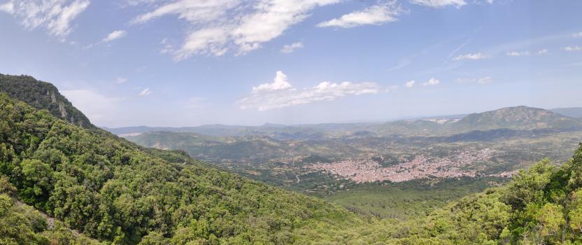
Mounts Hinele (Oliena town center, 440 meters above sea level)
This stage marks the departure, from the town center of Oliena, of the cycle-pedestrian route (ascent to Maccione and Tuones) numbered in the Hiking Network as B-403. A few meters (60, to be exact) from this point begins the other local hiking trail, the B-401 hiking trail "Su Carmene-Corrasi".
How to get here
It is located in the upper part of the town of Oliena, at the intersection of Via Sardegna and the provincial road 22 (the cement road that goes up to Maccione).
Monti Hinele (abitato di Oliena, 440 mslm)
Questa tappa è la partenza, dal centro abitato di Oliena, del percorso ciclo-pedonale (salita a Maccione e Tuones) numerato nella Rete Escursionistica come B-403. A pochi metri (60, per l'esattezza) da questo punto parte l'altra direttrice escursionistica paesana, il sentiero escursionistico B-401 "Su Carmene-Corrasi".
How to get here
Si trova nella parte alta dell'abitato di Oliena, all'incrocio tra la via Sardegna e la strada provinciale 22 (strada in cemento che sale a Maccione)
Pathways Oliena - Tuones Viewpoint (B-403)
Pathways Oliena - Belvedere Tuones (B-403)
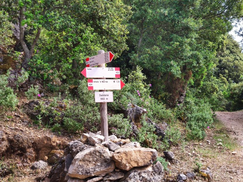
Sa Podda (Junction 406-401)
This junction point between the B-401 (Corrasi) and B-406 (Gologone) trails is panoramic and crosses the holm oak undergrowth.
Sa Podda (bivio 406-401)
Questo punto di snodo tra i sentieri B-401(Corrasi) e B-406 (Gologone) è panoramico ed attraversa il sottobosco di lecci.
Su Gologone (Trail B-406)
One of Sardinia's most visited sites, sculpted by the power of water and immersed in an oasis of lush vegetation.
It evokes the freshest water and generous greenery. Su Gologone, at the foot of Mount Uddè, in the territory of Oliena, from which it is fifteen kilometers away, is Sardinia's most important spring, a natural monument since 1998, and the main resurgence of the vast karst system of the Supramonte. Over millennia, the water has carved meanders through the bowels of the subsoil to resurface as a small lake nestled between high walls of dolomitic rock. Its shades range from emerald green to turquoise, to intense blue, depending on the reflections of the sun.
You will hear the incessant roar of the imposing mass of purest oligomineral water – an average of 500 liters per second – gushing from a dizzying, perpetually full fissure. Clarity and depth are an irresistible challenge reserved for speleodivers who come from all over the world: in 2010, Alberto Cavedon explored it down to 135 meters.
From the spring originates a short stream that flows into the Cedrino and constantly feeds the fifth longest river on the island. Depending on the seasons, you will see its metamorphosis: impetuous during floods, placid rest during dry periods. From the springs, you can start kayaking along the canyon and the lake formed by the watercourse, a very evocative river route. The scenic spectacle of the source is completed by the eucalyptus forest where you can have quiet picnics. If the water is the main attraction, the lush surroundings are worth a leisurely stop.
Su Gologone is set in a unique landscape and historical-archaeological context. A stone's throw away is Nostra Signora della Pietà, an example of rural sacred architecture. Deep canyons open up in the Supramonte: the Lanaittu valley is just seven kilometers from the springs. Inside are the Nuragic villages of Tiscali and sa Sedda ‘e sos Carros, and the Corbeddu caves – the site of discoveries that have written the history of human presence in these parts – sa Oche ‘e su Bentu, another natural monument, and the marvelous Ispinigoli, in the territory of Dorgali. Hikes of varying difficulty reach the peaks of Oliena: Mount Corrasi (1463 meters), with its rich flora and fauna, and the peaks sos Nidos and Cusidore.
How to get here
This stage is the arrival point of trail 406, which branches off from trail 401 (the Oliena-Corrasi hiking route) near Sa Podda. Here is also the junction with trail 409, which reaches Ruinas and Sa Oche in the Lanaitho valley.