Nordic Walking
La camminata nordica o camminata con bastoni (in inglese nordic walking o pole walking) è attività fisica e sportiva che ben si coniuga con percorsi in bosco, in pianura o in vallate, lungo scogliere o spiagge. La Rete dei sentieri della Sardegna offre tantissime occasioni per cimentarsi nella camminata nordica...

Results
Pathways Oliena - Monte Corrasi (B 401)
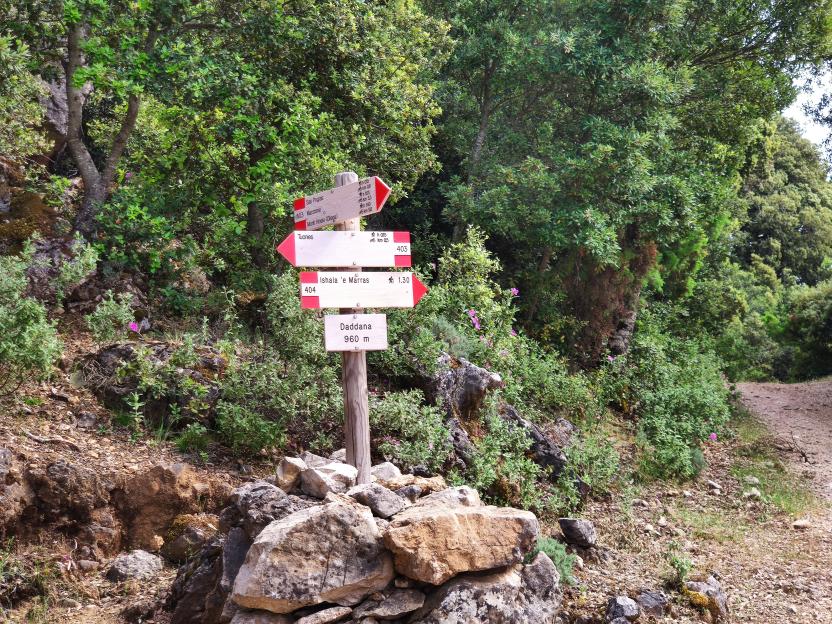
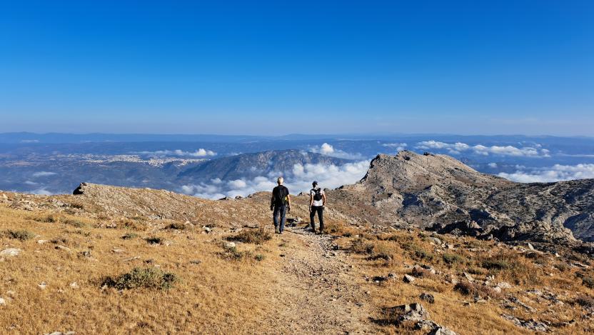
Pathways Oliena - Tuones Viewpoint (B-403)
Pathways Oliena - Belvedere Tuones (B-403)
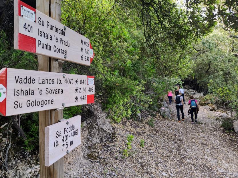
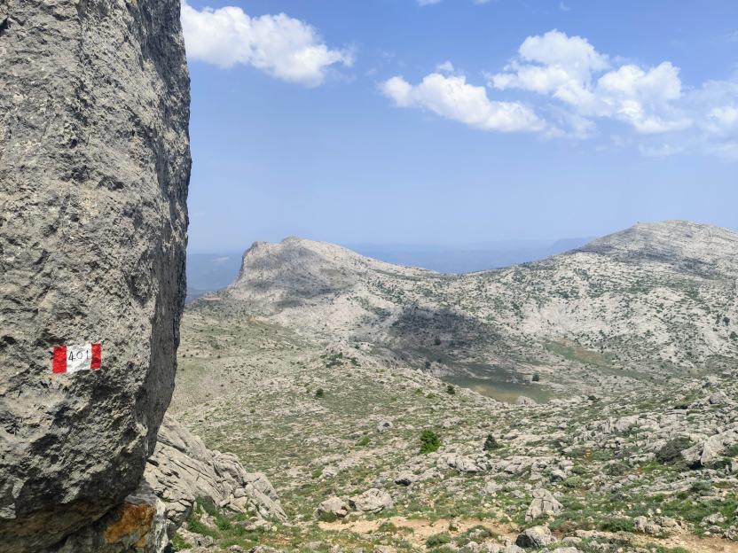
Pathways Sa Podda - Su Gologone (B-406)
Pathways Sa Podda - Su Gologone (B-406)
Ollolai, San Basilio. A kingdom of granite
Access
The San Basilio Park is well signposted and from the inhabited centre of Ollolai you take a convenient uphill asphalt road, very panoramic, which leaves the village behind and soon plunges into a forest of Holm oaks. From the asphalt road you change to concrete, soon passing the astronomical observatory of San Basilio, and the Planetarium of Ollolai, located on the right-hand side of the road. You continue for a short distance over a few slopes until you reach a large clearing after which the rolling road begins to descend with tight hairpin bends.
San Basilio
The mountain overlooking the village of Ollolai, once one of the most important centres in the area, is dedicated to San Basilio Magno, and the small road leads to the church dedicated to the saint, built in Byzantine era and then renovated several times, in front of which, are the ruins of the convent that once belonged to the Franciscans, and is the theatre of many legends. Just below the church and a spring, often dry in the hottest summers, there is a vast clearing surrounded by a dense Holm oak forest and an impressive series of granite peaks which are incredibly broken and varied. On the left, at the top of Sa Punta Manna, which you could reach via a route marked with some ropes, however it requires experience of short climbs along a path, to be tackled only if you are an experienced mountaineer and the rocks are dry.
The sign of history
The area of San Basilio was, however, inhabited in much earlier times than the church and convent can testify. The numerous caverns carved out by erosion in the granite tafoni have been inhabited, with certainty, since the Neolithic period, as many archaeological investigations testify. Hollowed-out rock shelters are scattered throughout the area, and to get an idea of the territory in which the proto-Sardinians operated, it is worth spotting, just below the small church, a fence that one meets on the right, towards the direction of the field. Beyond it, you come to a fairly obvious little path that begins to climb steeply in the middle of the wood, marked by the passage of people and bicycles, but with no trail signs or markings. You then reach a wide ridge in the middle of the forest where you come across a more visible track, the remains of a disused dirt road. Take it to the right, soon arriving near the communication mast that towers above the area. There are numerous sites of archaeological interest in the vicinity, although they are poorly signposted. After a visit to the scenic rocks near the antenna, you take the dirt road to the right, going downhill and soon returning to the tarmac road that leads back to the village.
Tipologia itinerario
- Log in to post comments
Photogallery
Ollolai, San Basilio. Un regno di granito
Accesso
Il Parco di San Basilio è ben indicato e dal centro abitato di Ollolai si prende una comoda strada asfaltata in salita, molto panoramica, che si lascia il paese alle spalle tuffandosi ben presto in un bosco di leccio. Dall’asfalto si passa al cemento, sfiorando in breve l’osservatorio astronomico di San Basilio, il Planetario di Ollolai, posto sulla destra della strada.
Si prosegue ancora per un breve tratto con scarse pendenze fino ad arrivare ad un ampio slargo dopo il quale la rotabile comincia a scendere con stretti tornanti.
San Basilio
Il monte che sovrasta il paese di Ollolai, un tempo uno dei centri più importanti della zona, è dedicato a San Basilio Magno e la stradina conduce proprio alla chiesa dedicata al Santo, edificata in epoca bizantina e poi ristrutturata più volte, davanti alla quale si trovano i ruderi del convento che fu dei francescani, teatro di molte leggende.
Poco sotto la chiesa e una sorgente, spesso in secca nelle estati più calde, si trova una vasta radura circondata da una fitta lecceta e da una impressionante serie di cime granitiche incredibilmente rotte e variegate. Sulla sinistra la cima di Sa Punta Manna sarebbe raggiungibile tramite un percorso segnato con alcune corde, ma richiede esperienza di brevi arrampicate lungo un percorso dal sapore alpinistico, da affrontare solo se si è esperti e con roccia asciutta.
Il segno della Storia
L’area di San Basilio era però frequentata in tempi assai più remoti di quelli che chiesa e convento possono testimoniare. I numerosissimi antri ricavati dall’erosione nei tafoni granitici sono stati abitati con certezza fin dal neolitico, come testimoniano molte ricerche archeologiche. I ripari sotto roccia scavati sono disseminati nell’area e per avere un’idea del territorio in cui si muovevano i protosardi è opportuno individuare, poco sotto la chiesina, una staccionata che si incontra sulla destra in direzione del campo.
Superatala, si incontra un sentierino abbastanza evidente che prende a salire deciso in mezzo al bosco, segnato dal passaggio delle persone e delle biciclette, ma privo di segnavia. Si raggiunge così un largo crinale in mezzo al bosco dove si incontra una traccia più marcata, quanto resta di una sterrata disastrata. La si prende sulla destra, giungendo in breve nei pressi del ripetitore che sovrasta la zona. Nei dintorni si trovano numerosi siti di interesse archeologico, anche se mal segnalati.
Dopo una visita alle panoramiche rocce nei pressi dell’antenna si prende la strada bianca sulla destra, perdendo quota e ritornando in breve alla strada asfaltata che ritorna al paese
Tipologia itinerario
- Log in to post comments
Photogallery
Sentiero Italia (Stage Z16) Sa Senipida - Ilodei Malu (Caserma Montes)
Overview of the itinerary
Sentiero Italia runs the length of the island’s eastern side, covering its most important mountains, in 28 stages. Starting from the north: it flanks the Monte Limbara massif, crosses the limestones of Mont’Albo and Tuttavista, skirting the Gulf of Orosei, it crosses the Supramonte, Gennargentu and the Tacchi of Ogliastra and reaches Perdasdefogu. Further south, it passes through Armungia and the Gerrei sub-region. Lastly, it touches on the villages of Burcei and San Gregorio, continuing on the Sette Fratelli massif to the old prisons of Castiadas.
General information on Sentiero Italia (Grand Italian Trail)
Sentiero Italia, or Grand Italian Trail, as also explained on the official website, is a walking route that crosses the whole of Italy, using mainly but not exclusively “registered trails”.
In particular, in Sardinia, not all the stages of the Sentiero Italia of CAI (Italian Alpine Club) are made of trails already included in the registry of the Sardinia Trail Network (RES), either because they have not yet been tested and approved or simply because they cannot be registered as they do not meet the requirements. However, as a whole, the Sentiero Italia is the single longest walking route currently crossing Sardinia from the north (S. Teresa Gallura, stage Z 1) to the south (Castiadas, end of stage Z 28), touching on the most fascinating mountain areas in central-eastern Sardinia: the plateau of Buddusò, Tepilora, the Cedrino river valley, the ancient forests of Montes, Perda Liana and the regional forest of Montarbu, Monte Genis, and lastly the regional forest of Settefratelli (among the many crossed by the various stages of this long hiking itinerary).
Information on this stage of the trail
The planned stop point at the cuile Sa Sinipida can currently be used as a camping point, with a spring nearby. For support, please contact Efisio Manca, mobile 3202745951.
The route begins with an easy dirt track that leads to the crossing of the Badde Tureddu stream and then winds uphill passing a spring. At 987 m asl, trail 441 leaves the dirt track and enters the forest. A beautiful trail through a forest of holm oaks and cork trees with route markings on trees and stone cairns. Once past the forest, continue along the trail that becomes a dirt track just before the camping point of ziu Mulittu (two fairly comfortable stone huts).
At the 441-441C fork, continue north-west on 441 towards the ruins of the cuile (sheepfold) of Sos Pisanos and then go up towards Monte Novo San Giovanni where a fire lookout overlooks a vast unspoilt territory. After leaving Monte Novo, continue south-west towards Monte Fumai, at 1316 m asl, and then head north towards the forest ranger station of Montes (Ilodei Malu).
Informazioni utili
Tipologia itinerario
- Log in to post comments